Category: Travel

  • Western Yunnan Travel Guide: Exploring Local Food and Scenic Towns

    Western Yunnan Travel Guide: Exploring Local Food and Scenic Towns

    Preface

    As the year draws to a close, the intense pace of work often leaves me feeling breathless. I inevitably start to think about spending some time living elsewhere to truly rest both physically and mentally. Many content creators have recommended cities suitable for long-term stays, and I’ve been wondering which place would suit me best. A good climate is essential for any place to live, which is why I’ve been flying to Yunnan more frequently over the past two years to explore cities known for their spring-like weather all year round. Tengchong and Mangshi are often mentioned as ideal places to live, so this year I took some annual leave to briefly experience what it’s like to stay here. Aside from the climate, what I value most are good food and beautiful scenery. This article focuses on these two aspects to document my experience, along with a brief comparison of which small town in western Yunnan might be more suitable for long-term living.

    Staying in an Ancient Town

    Food in the Ancient Town

    Tengchong does not have a high-speed rail station, and its airport is relatively small, making direct transportation somewhat inconvenient. We first transferred through Kunming before flying here. Alternatively, you can fly to Mangshi or Baoshan and take a bus to Tengchong, which takes about an hour.

    After arriving in Tengchong, we chose to stay at a homestay called “Tang Tang’s Home” in Heshun Ancient Town. The suite costs 472 RMB per night, and the homestay offers airport pickup service. It takes about 20 minutes to reach the town from the airport. To enter the ancient town, visitors need to purchase a ticket using their ID card—55 RMB for adults, with discounts available for students and seniors. Each ticket is valid for seven days and allows entry and exit using the same ID.

    The four Pomeranians kept by the homestay owner, along with the stray cats by the roadside

    When we first arrived in Tengchong, we chose to stay in the ancient town mainly because of the airport pickup service and the convenience of finding food nearby. Within a ten-minute walk from the homestay, there are many restaurants to choose from. Passing by “Cuixi Lou” near Wild Duck Lake, we noticed a promotional sign offering a plate of Da Jiu Jia (stir-fried rice cakes with pork and other ingredients) for only 9.9 RMB, along with free barley tea. Another restaurant called “Mom’s Taste” offers stir-fried Jian Shou Qing mushrooms for 98 RMB and stir-fried porcini for 88 RMB. Sitting by the window, you can enjoy the sunset while dining.

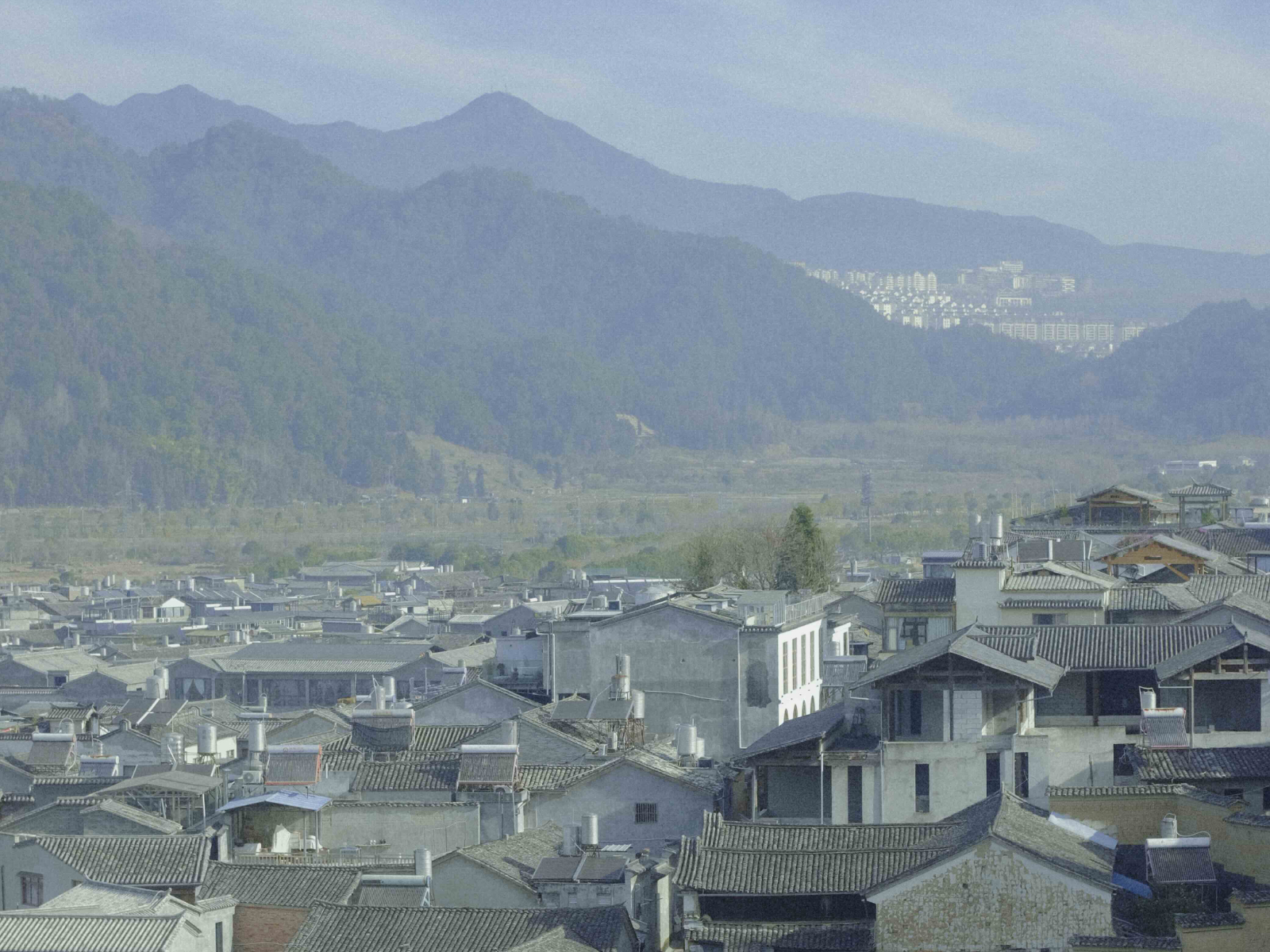
    Viewing the ancient town’s panorama from a high vantage point

    In addition to the many restaurants, the main street is filled with local snacks worth trying. One popular shop, “Heshun Crispy Roast Pork Trotters,” sells braised pork trotters that are roasted upon order and take about 20 minutes to prepare. You can choose either a whole or half portion—the half portion costs 25 RMB. The shop cuts it into pieces, each consisting of a small section of bone attached to tender meat, making it easy to eat. The skin is crispy while the inside remains juicy and rich without being greasy.

    The morning market on the century-old Caijie Street offers even more snack options. Thin pea flour paste, made from ground peas, is one of the must-try local foods. “Auntie Yang’s Breakfast Shop” serves a 6 RMB set of this dish, which can be paired with flatbread or fried dough sticks. Street vendors also sell pine blossom cakes everywhere—three pieces for 5 RMB—which taste somewhat similar to mung bean cakes.

    The ancient town’s morning market is bustling with people.

    Scenery of the Ancient Town

    The ancient town is not only known for its food but also for its long history. According to ancient texts such as the Old Book of Tang, Tengchong was historically known for producing rattan, and its name originally meant “a place abundant in rattan.” During the Ming Dynasty, Tengchong Prefecture was established and it was known as “the First City at the Frontier.” In the Qing Dynasty, troops stationed here resisted British incursions. During the Republican era, Japanese forces invaded western Yunnan and occupied the area. Two years later, the Chinese Expeditionary Force launched a counteroffensive in western Yunnan and successfully recaptured Tengchong. After the founding of the People’s Republic of China, Tengchong was peacefully liberated and placed under the administration of Baoshan.

    The town’s architecture is well worth exploring at a leisurely pace. Not far from our homestay stands Yuanlong Pavilion, in front of which lies Longtan Pond. In the early morning, the pavilion is often surrounded by mist, creating an ethereal atmosphere. The Liu Clan Ancestral Hall and Li Clan Ancestral Hall are adorned with numerous inscribed plaques and couplets, set within tranquil surroundings. The ancient town is home to nine ceremonial archways, built to commemorate achievements and virtues such as loyalty and filial piety, and they have now become popular photo spots.

    Longtan Pond shrouded in morning mist
    Wild Duck Lake can be seen outside the Li Clan Ancestral Hall
    One of the town’s popular photo spots—the four characters on the archway signify that neighbors should live in harmony, as in ancient times

    The highly rated Chinese TV drama My Chief and My Regiment was primarily filmed in Heshun Ancient Town. We passed by filming locations such as “Milong’s Home” while riding the sightseeing shuttle. The driver grew up in the town, and the crew had filmed near his home at the time—he was even recruited as an extra. The crew gave him a bunch of bananas, which he thought were for him to eat, so he shared them with his friends. Only later did he realize the bananas were actually props for a scene depicting villagers welcoming returning troops with fruit and food.

    One of the filming locations of My Chief and My Regiment: “Milong’s Home”

    The town is not limited to ancient buildings—there are also many cafés and bookstores ideal for spending a slow afternoon. “Shu Shu Bookstore” is a multifunctional space that combines a bookstore, café, and hotel. The bookstore features a unique layout where you can read on tiered steps surrounded by bookshelves, or head to the café to overlook the panoramic view of the ancient town. If you wish to stay longer, you can even spend a few nights here, and guests are allowed to borrow any unsealed books for free. My only slight regret was that the bookshelves were somewhat disorganized, and there were very few detective novels available—only a few copies of The Adventures of Sherlock Holmes.

    The reading area in the bookstore is surrounded by bookshelves on all sides.

    Volcanoes and Hot Springs

    Food in Tengchong

    To experience the volcanoes and hot springs, we left the ancient town and headed to the city center. I wasn’t as familiar with the food scene here as I was in the ancient town, but I had heard that Tongpiao Beef was worth trying. The copper pot used for Tongpiao Beef originates from the Bai ethnic group’s copper utensils along the Ancient Tea Horse Road, and the charcoal-heated hotpot style continues the tradition of gathering around a stove at roadside stations along the route. We visited “Ma Dong Halal Tongpiao Beef Restaurant” and ordered a clear broth base with ingredients such as Chinese cabbage and white radish. At least 500 grams of beef must be ordered, and each slice is cut very thin—ready to eat after about a minute in the pot. Dipped in a variety of sauces, the beef was tender and flavorful. The meal cost 110 RMB.

    The Tongpiao Beef comes with a rich selection of side ingredients

    Our homestay in the city was located in the newer northern district. Nearby, there was a well-known wild mushroom hotpot restaurant called “Shanzhen Guan,” with photos at the entrance showing actor Shen Teng dining there. We chose a chicken broth base, with truffle and Huanglaitou mushrooms in the pot, and also ordered a portion of fried rice with dried Ganba mushrooms.

    After the broth was served, the mushrooms had to be cooked for 30 minutes without stirring with chopsticks. The staff brought us oranges and stir-fried mushrooms as appetizers while setting a timer. Once the time was up, we could finally enjoy the mushroom soup. Although we ordered a medium-sized broth and half portions of each mushroom, the quantity was still quite large—we couldn’t finish it all.

    The most expensive item in the meal was the truffle, priced at 154 RMB for a half portion. According to the staff, it has immune-boosting benefits, and since some fresh ones were still available, they recommended it to us. A half portion of Huanglaitou mushrooms cost 57 RMB and is best for enhancing the flavor of the soup. In total, the meal came to 462 RMB.

    Snacking while waiting for the mushrooms to cook

    Our homestay host also recommended a restaurant called “Huayu Diandian,” which offers both barbecue and main dishes. When we arrived around 6 p.m., we were told there were 20 tables ahead of us, with an estimated 40-minute wait. I ordered a local specialty dessert from Dehong Prefecture called Paoluda to pass the time—it’s made with milk, shredded coconut, tapioca pearls, and other ingredients, resulting in a sweet and refreshing treat.

    Dehong’s signature dessert: Paoluda

    While waiting, I asked the owner if we still had to wait if we didn’t order barbecue. He said no, so I ordered braised noodles instead. When the dish arrived, I was taken aback—northern-style braised noodles are typically made with vegetables and meat without any chili, but Tengchong’s version was spicy. I was dealing with a sore throat at the time and couldn’t handle any spice, so I had to order another plate of Da Jiu Jia to “save the day.”

    The crowded barbecue ordering area

    I had very few chances to eat vegetables during these days. Near Beihai Wetland, there are many farmhouse-style restaurants with kitchens stocked with fresh leafy greens. I ordered stir-fried bok choy and tofu soup with greens. The bok choy was stir-fried with chili and garlic, making it an excellent dish to go with rice. The tofu in the soup was incredibly soft, breaking apart at the slightest touch—each bite was soothing to the palate.

    A farmhouse restaurant near Beihai Wetland, with a variety of wild vegetables and cured meats hanging above

    Aside from restaurants, the city also has plenty of street snacks. In southern Tengchong, there is a place called Qiluo Ancient Town, known for its morning market. After soaking in a hot spring one day, I went there for a meal and tried a Bai ethnic traditional snack I had never tasted before—grilled Rushan. Made primarily from milk, it is stretched into thin sheets, grilled over charcoal, and brushed with seasoning before serving. The vendor told us he wasn’t Muslim and used to sell jade, but turned to running a food stall when business declined. He was very kind—after handing us the grilled Rushan, he even gave us two passion fruits for free.

    The morning market in Qiluo Ancient Town—when I arrived after noon, the crowd had already thinned and many vendors were packing up

    There was also a herbal medicine vendor at the market. As we had been suffering from insomnia recently, we bought some sour jujube seeds. The vendor examined our tongues and facial features, then explained some health issues we might be facing. Noticing the blackheads on my nose, he said it indicated lung-related problems and advised me to take better care of my health, sharing several stories of “friends” who had passed away due to neglect. It felt like sitting in Professor Trelawney’s Divination class in Harry Potter, listening to her predict a tragic fate.

    I think the best food at the morning market was the crispy layered buns. I found a highly rated shop on the map called “Fang Jie Special Crispy Buns.” From the entrance, it takes a ten-minute walk down the alley next to the ancient town library to reach it. As the saying goes, good wine needs no bush—these buns sell out quickly. By the time I arrived, only rose rolls and mushroom buns were left. On the way back, I spotted another barbecue stall, where beef skewers sizzled on the grill, and couldn’t resist buying a few.

    The vendor grilling yellow cattle beef skewers

    Scenery in Tengchong

    Tengchong sits on the boundary between the Indian Plate and the Eurasian Plate. It is the region within China with the highest density of volcanoes and the largest number of volcanic sites. Tengchong is also one of China’s three major geothermal zones, earning it the nickname “China’s Hot Spring Capital.” Beyond volcanoes and geothermal activity, Tengchong boasts many other distinctive geological wonders. Beihai Wetland, formed by a volcanic lava dam, has become Yunnan’s only national wetland nature reserve. To the east of Tengchong, the Gaoligong Mountains are home to a rich variety of rare flora and fauna.

    Choosing to stay in the northern part of Tengchong was driven less by “food” and more by “scenery.” Our homestay was close to the Tengchong Volcano and Geothermal National Geopark, making it easy to head out early in the morning to watch hot air balloons. The geopark’s balloons only fly before 11 a.m.; after that, flights stop due to weather conditions. I didn’t enter the park itself. Instead, I drove along County Road XM74 to the outer edge of the park. There is a broad stretch of grassland along the road, and when I arrived it was completely empty—perfect for viewing the volcanoes up close. Hot air balloons rose and fell across the sky, and I couldn’t help but think of Cappadocia in Turkey.

    Xiaokong Mountain framed with hot air balloons. Its relative height is only 40 meters and it’s almost hidden by the trees.

    Continuing along the county road, we spotted a crowd feeding monkeys by the roadside—these are local stump-tailed macaques. Some villagers were selling peanuts: three bags for ten yuan. The monkeys wouldn’t touch the bread I brought, so I had no choice but to buy peanuts. The villagers told me to keep the peanuts hidden in my pocket and only take out one at a time, placing it low in my hand—then the monkeys would naturally come over and take it. It worked exactly as they said. But the clever monkeys noticed me reaching into my pocket, and one after another stood up and pawed at my pockets.

    I took a few steps back, trying to feed a little monkey, but the bigger ones kept snatching the peanuts. Yet when I took out my camera to photograph the little one up close, the bigger monkeys would rush over to shield it, as if afraid I might hurt it. Their half-friendly, half-hostile attitude was honestly hard to read.

    A little monkey eating

    I parked in the free lot at “Xiabiayuan Mushanju.” Across the road, there’s a path leading down to the Heiyu River. This river formed after volcanic eruptions, when lava blocked an underground river channel and groundwater emerged at the surface. It’s named Heiyu River (“Black Fish River”) because every summer and autumn, tens of thousands of small black fish surge out from the spring source.

    According to travel tips I’d seen on Xiaohongshu, you can reach the river by going down a set of stone steps—but few people mention how difficult the route actually is. The steps are essentially unmaintained: most are narrow, and the slope is steep, making both the descent and climb quite inconvenient. Even with a trekking pole, I was still panting the whole way, having to use both hands and feet to avoid slipping.

    Heiyu River is a low-temperature hot spring river. The current is fast and the water is crystal clear. When I reached the riverbank, I tested the temperature with my hand. It wasn’t as warm as people online claimed, but it also wasn’t cold. As I walked further, the water gradually turned an emerald green. On both sides were rocky riverbanks formed as volcanic rock was eroded by the flow.

    Beihai Wetland and Heiyu River share a similar origin—both were formed through volcanic activity. Lava blocked underground waterways and created a lake, giving rise to China’s only floating-mat wetland of a volcanic lava-dammed lake. Admission to the wetland is 55 yuan per adult. Inside, there are all kinds of waterbirds and wild ducks. You can take a boat into the wetland to observe plants and animals; a one-way trip takes about 15 minutes and costs 60 yuan per person.

    Heiyu River and Beihai Wetland

    After getting off the boat, a long wooden boardwalk stretches out, with water caltrop plants growing densely on both sides. This plant requires exceptionally clean water and is rich in gelatinous proteins, making it an excellent ingredient for skincare products. It’s nicknamed the “giant panda of plants” and the “bird’s nest in water.” From the boardwalk, you can take a cable car back to the entrance; a one-way ticket is 10 yuan per person.

    Beihai Wetland in early February felt rather quiet. I only saw two or three kinds of waterbirds, and with so many paid add-on activities inside the park, I began to understand why Xiaohongshu is full of posts warning people to avoid this place. You can catch the sunset if you stay until around 7 p.m., but the wind in the wetland was strong, so we left after a short while.

    Where volcanoes are active, hot springs are usually close by. Tengchong’s most famous hot springs are at Rehai’s “Big Rolling Pot,” a well-known tourist spot—and also the most crowded. All the pools there are public, and even if you arrive right at 9 a.m. when it opens, you still might not get anything close to a private soak. Tengchong hot springs mainly fall into two types: carbonated springs and sulfur springs. The driver who picked us up said locals usually go to Huangguaqing for sulfur springs.

    Huangguaqing is near Rehai. The word qing generally refers to a lush, wooded valley, and this place gets its name because the valley shape resembles a cucumber. But judging from online reviews, several hot springs in Huangguaqing are described as having a “pure prison vibe” or “dungeon vibe,” so I didn’t go. “Xianren Hot Spring” is also in the Huangguaqing area. It’s said to use sulfur spring water diverted from Rehai’s “Beauty Pool.” Besides public pools, it also offers private rooms, priced at 60 yuan per room.

    I arrived at Xianren Hot Spring around 10 a.m., and there were hardly any visitors yet. I called ahead to reserve a private room, and the staff told me they could start filling it early. But when we arrived, the water was still far too hot—over 40°C by touch. I turned on the cold-water tap for ten minutes before I dared to get in. There was also a ladle by the pool. I like using it to scoop hot spring water over myself until I’m completely drenched.

    The private room at “Xianren Hot Spring.” You can run the cold water yourself; for hot water you need to ask the staff.

    While soaking, I could feel my skin becoming smoother, just as people often say. But I didn’t smell the typical sulfur “rotten egg” odor, and there was no flocculent mineral sediment in the pool either. To judge whether it was truly a sulfur spring, I cupped a handful of water and sniffed carefully—what I caught was more of a gunpowder-like scent. I soaked for about an hour. Afterward, my skin was flushed and my body felt noticeably more relaxed.

    After we finished, the driver who came to pick us up said that when he was a child, he used to soak at “Dongshan Hot Spring” every day. Back then it cost only a few jiao per visit. Now it has become “Dongshan Hot Spring Resort,” where private rooms cost 40 yuan per person for a one-hour session. Compared with Xianren Hot Spring, the private rooms here are larger and brighter, though this one is a carbonated spring rather than a sulfur spring. The resort also has outdoor public pools—many tucked away in the woods, so you have to search carefully to find them. I even saw people using their phones’ navigation to locate specific pools.

    The private room at “Dongshan Hot Spring Resort”

    From Tengchong to Mangshi

    Food in Mangshi

    Mangshi is about an hour’s drive from Tengchong and is a small city perfect for leisurely walks. After arriving, I first went to “Best Food City” and ordered a mango juice for 15 RMB from the Xiaohongshu-recommended “Fatty’s Cold Drinks.” With the juice in hand, I headed to “Ajiji Burmese Tea Restaurant” and ordered a Thai-style lemon shrimp and a Burmese egg Shuaibaba.

    Inside Ajiji Tea Restaurant and the recommended menu

    Having learned my lesson from the spicy braised noodles, I specifically asked the chef not to add chili to the Thai-style lemon shrimp. The dish consisted of shrimp paired with cucumber and shredded radish, with plenty of minced garlic. Burmese egg Shuaibaba is a thin pancake made from high-gluten flour with egg wrapped inside and sprinkled with sugar on top. One dish leaned sweet, the other savory—perfectly suited to my taste.

    Unlike Best Food City, “Mengbanaxi Food City” focuses on barbecue and has a more vibrant street-food atmosphere. When I arrived around 6 p.m., many stalls hadn’t opened yet. There was a long queue at a Burmese Shuaibaba stall, so I joined and bought one for 12 RMB. Next to it was a stall displaying a sign that read “Best-Looking Dish of the 2025 Mangshi Flavor Food Competition,” selling a cold mixed dish made with crushed peanuts and Houttuynia cordata, priced at 10 RMB.

    Stalls at Mengbanaxi Food City

    Sa Pie is a traditional Dai ethnic dish made using the bitter intestinal juices from cattle as seasoning in a cold mix. At “Su Jie Border Snacks” in Mengbanaxi Food City, various types of Sa Pie are available. I ordered the nut-based version, which was mixed with a nut paste that gave it a slightly milky aroma. It is typically served with rice noodles, beef liver, and mint—dipping the side ingredients into the Sa Pie results in a refreshing sweet-and-sour flavor.

    While looking for a restroom in the city center, I stumbled upon “Baomin Ganbai Street,” known for its border-style snacks. I ordered Burmese fish soup rice noodles and stir-fried shredded potatoes, along with lemon water. The fish soup noodles were generously portioned with fish fillets, fried fish skin, and egg. The stir-fried shredded potatoes were the only version I encountered in Yunnan that didn’t include chili. The lemon water was strong and filled with pulp. Even though it was just a random roadside find, the taste was surprisingly good.

    Sometimes we didn’t feel like going far and just wanted to grab something near the hotel. We stayed at “Huanman Hotel,” which had many restaurants nearby. Across the street, “Mianguihua Dai Cuisine” specializes in Yunnan dishes, and there was always a queue outside. At “Keduomi,” we ordered fried rice with dried Ganba mushrooms and were given complimentary mini bananas. “Chan Sisters Clear Soup Beef Breakfast” is known for its beef Ersi—a children’s bowl costs 6 RMB and is already quite filling, with tender beef that tastes even better when paired with condiments.

    Children’s bowl of beef Ersi and condiments

    Later, we also tried clear soup beef Ersi at “Lianmei Breakfast,” which was just as delicious. Sometimes when we woke up late, it would already be past 9 a.m., yet there would still be a long queue outside—waiting about 40 minutes just to get a bowl. It made me think back to my workdays, when I would hastily grab a couple of bites of breakfast at 7 a.m. every morning. The contrast felt almost surreal—slow living became tangible in that moment.

    After eating so many street snacks, we wanted a proper sit-down meal. “Mandeli Burmese Tea Restaurant” is located in the city center and offers a much more elegant dining environment compared to roadside eateries. We ordered a chicken pancake and a Burmese-style vegetarian salad, paired with banana juice—just enough to fill us up. We had expected restaurant prices to be much higher than street stalls, but the total came to 96 RMB, which was quite reasonable.

    After visiting an overly commercialized Dai ancient town, we lost interest in Mangshi’s old towns and almost missed “Mangwei Yunnan Cuisine” in Manghuang Village. Upon arriving, we realized the village wasn’t just full of Dai ethnic costume photography studios but also many dining options. The private rooms at Mangwei Yunnan Cuisine offered excellent privacy. Walking in from the noisy crossroads at the village entrance felt like entering another world. The egg-coated tofu had a crispy exterior and silky interior, the pineapple fried rice was generous and filling, and the tremella soup was nourishing and comforting—all dishes not to be missed. The prices here were similar to Mandeli Burmese Tea Restaurant; the total for this meal was also 96 RMB.

    Private rooms at Mangwei Yunnan Cuisine and the egg-coated tofu

    Scenery in Mangshi

    After dinner, I often like to ride a bicycle around Peacock Lake. The entire lake area is surrounded by Leiyarang Mountain, covered with dense forests that provide exceptionally high oxygen levels in the air. An ecological walkway runs along the lake, where many people can be seen strolling or jogging. Next to “Laihui Coffee” are a few steps facing the lake—sitting there and watching egrets skim across the water is pure bliss.

    Peacock Lake at sunset

    Menghuan Grand Golden Pagoda sits atop Leiyarang Mountain and is a landmark of Mangshi, known as the “largest hollow Buddhist pagoda in Asia.” This pagoda is an important site for Theravada Buddhism, reflecting the long-standing cultural exchange in the China–Myanmar border region. I visited on a Sunday, and the road leading up the mountain was completely jammed with vehicles. It was difficult to find parking, so I stayed in the car and admired the pagoda from a distance.

    The Grand Golden Pagoda photographed from the car, and from Peacock Lake

    Another example of the China–Myanmar cultural blend in Mangshi is the Burmese-style hair washing services commonly found on the streets. I went to the main branch of “Bangbang Hair Wash House” and chose the “hair wash + back stretch with essential oil shoulder and neck massage” package. For two people, the total cost was 271 RMB, taking about 80 minutes. My therapist was a sturdy Burmese man in his twenties. He began by washing my hair and applying a facial mask before starting the massage.

    The waiting area at the entrance of “Bangbang Hair Wash House”

    His massage was quite strong, but since my fitness coach sometimes uses massage to help me relax, I was able to adapt to his rhythm. My shoulders and neck had become very stiff from prolonged use of my phone and computer, and I could feel him applying significant pressure to loosen the muscles. My back felt sore immediately after the massage, but a few hours later, there was a noticeable sense of relief and release in my shoulders and back.

    Mangshi is not large, making it ideal for exploring by electric scooter. I rented a shared bike from outside the hotel and rode to the internet-famous wall near Century Hotel and Bodhi Street. Each spot is about a ten-minute ride apart. The wall is tucked into a small alley next to staff housing, while Bodhi Street is busy with traffic—both are more suitable for quick photo stops rather than lingering visits.

    The internet-famous wall and Bodhi Street

    The Tree-Wrapped Pagoda is a landmark formed by a Qing Dynasty-era pagoda built around 200 years ago and a Bodhi tree growing together. Compared to the previous two spots, there’s at least a small square here, allowing you to photograph the tree from all angles. Nearby residential developments are currently under construction, so we stopped by the sales center to inquire about housing prices—the average is around 6,300 RMB per square meter.

    One of Mangshi’s landmarks: the Tree-Wrapped Pagoda

    In the Bingwu Street area of Mangshi, there is a lively market where vendors from Dai, Jingpo, and other ethnic minority groups sell wild mountain ingredients and traditional clothing. The market is held once every five days, with the busiest period between 9 a.m. and noon. As I wandered through, I saw stalls selling soy pods, fruits, decorative fruit shells, and even live roosters—it was a vibrant scene.

    Vendors at the market

    After visiting all the major attractions in the city, we began exploring the outskirts by bicycle. Back in Tengchong, our driver had mentioned that the rapeseed flowers were about to bloom, so we rode to the ecological rural tourism area north of Mangshi. At the edge of the farmland was a large field of blooming rapeseed flowers, surrounded by potato crops, with several farmers busy at work.

    Blooming rapeseed flowers in the outskirts of Mangshi

    Conclusion

    Tengchong and Mangshi have similar living costs and both offer ancient towns, lively markets, distinctive local cuisine, and pleasant scenery—making them equally appealing for long-term stays. If I had to choose, however, Mangshi’s “small but beautiful” charm is more attractive to me compared to Tengchong. I like the towering Grand Golden Pagoda on the mountaintop, the tranquil Peacock Lake, the abundant breakfast options, and the freedom to wander around on an electric scooter. While living in Mangshi, I felt the pace of life slow down more noticeably. If given the chance in the future, I would love to stay in Mangshi for an extended period—to try the dishes I didn’t have time for and drive out to explore more distant villages.
  • Japan Autumn Foliage Guide: Best Places to See Fall Colors in Kanto

    Japan Autumn Foliage Guide: Best Places to See Fall Colors in Kanto

    After finishing the Kansai section in the previous post, I kept procrastinating on this one—only to see news breaking not long after I finally started writing, advising against travel. I had planned to give up on it, but eventually decided to treat this as a personal travel recap instead.

    This article is not intended as travel advice for visiting Japan, but rather as a personal travel memory for reference.

    Overview of the Kanto Itinerary:

    Day 5: Kobe Airport – Tokyo Haneda – Omotesando – Harajuku – Shibuya – Jazz Spot
    Day 6: Tokyo Disneyland
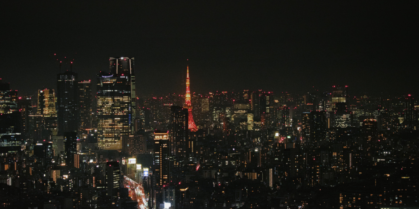
    Day 7: Senso-ji – Akihabara – Nakameguro – Daikanyama – Minami-Aoyama – Yurakucho – Tokyo Tower Shiba Park
    Day 8: Kamakura Station – Shichirigahama – Enoshima – Shonan Coast – Tokyo Dome LaQua

    Day 5: Arriving in Kanto, Wandering Through the City

    After four brief days in Kansai, we departed from Kobe Airport early in the morning on Day 5 and headed to Tokyo.

    Aside from Itami Airport being closer to Osaka’s city center, Kobe Airport and Kansai International Airport are located at similar distances. However, Haneda and Narita airports differ significantly in their proximity to central Tokyo, so we chose Skymark Airlines for its Haneda arrival. The ticket cost 419 RMB and included a 20kg baggage allowance. A Shinkansen ticket from Osaka to Tokyo costs nearly 800 RMB, so we passed after comparing prices.

    There’s also another budget-friendly option—overnight buses—which usually cost around 200–300 RMB and can save you a night’s accommodation.

    Worth mentioning is that when we arrived in Kansai, the weather was gloomy and rainy—but on the day we left for Kobe Airport, it was a cloudless, brilliantly sunny day. During the final above-ground train ride along Kobe’s coastline, the blue of the sky blending with the sea left me mesmerized—I completely forgot to take out my camera or phone.

    Only managed to snap a photo as we were nearing the station.

    Following our usual domestic travel habits, we arrived at the airport three hours early. Check-in and security at Japanese airports are quite simple, leaving us with plenty of spare time. Kobe Airport is small, with not much to browse, so we bought some Osaka-exclusive Calbee fries from a convenience store—they were delicious. Although Skymark is considered a low-cost airline, the actual flight experience didn’t feel cheap at all. Seat spacing and comfort were comparable to standard carriers, and complimentary drinks were provided—giving us a great first impression of domestic flights in Japan.

    After arriving in Tokyo, the subway system felt even more confusing. Sometimes Google Maps indicated no need to transfer, but after passing a station, the announcements didn’t match what was shown in the app, making the entire journey a bit nerve-wracking. Fortunately, we didn’t get on the wrong train.

    For a first-time visit to Tokyo, it’s important to stay somewhere with convenient transportation, reasonable proximity to major attractions, and solid amenities. The Akasaka Select Hotel, located near two subway lines, turned out to be a good choice. Aside from the typical Tokyo hotel drawback of limited space, there were hardly any other downsides.

    You can refer to my travel accommodation review for a more detailed stay experience.

    Unfortunately, our first day in Tokyo was also rainy. We had purchased 5 PM tickets for Shibuya Sky in advance via KKday. In addition to this observation deck, there’s also one in Roppongi. Since they offer different perspectives, it’s best to choose based on your daily itinerary. Our afternoon plan was to stroll from Omotesando all the way through Harajuku before heading from Shinjuku to Shibuya around 4:30 PM.

    We passed many famous shopping malls and stores along the way, but mostly just browsed without buying anything. If you plan to shop seriously, this amount of time definitely won’t be enough. Luxury stores along Omotesando had already put up their Christmas decorations, and even just walking by the architecture, storefronts, and window displays felt like a visual feast of festive aesthetics.

    Another goal in Harajuku was visiting the world’s first Fender flagship store. It spans four floors and is hard to miss thanks to its massive signage. The store wasn’t crowded—just a few people testing guitars in the seating area. You can browse freely without staff hovering nearby, which is very introvert-friendly, though I still didn’t dare try one myself. The interior is minimalistic, and walking through it felt almost like a pilgrimage. I ended up taking a photo of my dream electric guitar before leaving. The presence of English- and Chinese-speaking staff also means there’s no need to worry about language barriers if you plan to buy.

    On the way to Harajuku, we passed by a Mexican restaurant and decided to walk in, figuring we wouldn’t have much time to eat later. Both the staff and chefs appeared to be from Mexico, and the décor had a strong Mexican vibe. I honestly don’t remember how the food tasted, but it couldn’t have been bad.

    Harajuku’s streets are quite narrow, and navigating the crowd with umbrellas left us with little desire to shop—we just wanted to get out as quickly as possible. We hurried to Shibuya Station afterward to avoid missing our observation deck time. After exiting, there’s an observation elevator outside the mall—taking it up leads directly to Shibuya Sky. Due to the weather, the open-air deck was closed, so we could only view from indoors. Given Tokyo’s windy conditions that day, we might have been blown away if it had been open.

    Rain streaked across the floor-to-ceiling windows, and standing above the famous Shibuya Crossing didn’t feel as overwhelming as expected. But being up high somehow gives you a god-like perspective—tempting you to observe the people below and wonder what they’re thinking. Even though the night view looked similar from all sides, we lingered for quite a while.

    The lighting, atmosphere, and facilities inside the observation deck were excellent—there was even a bar. It’s not just a sightseeing stop, but a place where you can stay and relax.

    After leaving the deck, we crossed the very intersection we had just observed from above. In reality, the streets aren’t that wide—it’s the simultaneous crossing from all four directions that creates such a spectacular scene. Yet when you’re part of it, it doesn’t feel especially grand. Shibuya has plenty of shopping options nearby. My favorite was Loft—I kept thinking how much I would’ve bought if I had visited back in my student days. Unfortunately, now that I’m working, I rarely need stationery, and had to stop myself from spending impulsively.

    Beyond stationery, other floors offered digital gadgets, beauty products, and more—so many things to browse that it became overwhelming. During the Christmas season, the first floor was filled with decorations and greeting cards. An entire pillar was dedicated to various Christmas cards, and my friend and I struggled to choose until the mall was about to close. One of the main reasons I love Christmas is the decorations—regardless of how you feel about the holiday, it’s hard not to get caught up in the festive spirit.

    By 8 PM, Tokyo’s nightlife had officially begun. One of my travel habits is to have a drink at a local bar. Tokyo has no shortage of renowned establishments—several even rank among Asia’s Top 50—but we didn’t follow those lists.

    As the world’s second-largest music market, Japan has a deep jazz culture, which has even given rise to the unique concept of Jazz Kissa (jazz cafés). Jazz may feel a bit niche for everyday listening, but in a bar setting, it becomes instantly relaxing.

    So for our first night in Tokyo, we chose to visit Jazz Spot, located near Takadanobaba Station by Waseda University. Many local students come here to perform. The performances are informal—musicians rotate in and out freely, sometimes even emerging from the audience. Tokyo was cold and rainy that evening, and without a reservation, we were worried about getting in. Fortunately, there was no queue, and we were able to walk in. The cramped space quickly warmed us up, and we were seated in the front row, right next to the performers. No exaggeration—the guitarist’s instrument was practically in my face.

    We were so immersed that we forgot to take photos—this one was captured from a video.

    Drinks at the bar were also inexpensive: 1500 yen per person, with refills at 1000 yen. Even for someone like me who doesn’t know much about alcohol, the quality seemed average—but the atmosphere made up for it. With people from all over the world gathered in a small space, drinking and listening to jazz together, the experience itself felt very “jazz.”

    Tokyo also has other famous jazz bars, such as Blue Note Tokyo, Cotton Club Tokyo, and Pit Inn. We opted for Jazz Spot due to its affordability, but if your budget allows, the other three heavyweight venues are well worth considering for a warm and relaxing night.

    Day 6: Tokyo DisneySea

    Tokyo Disney Resort consists of two parks: Disneyland (Land) and DisneySea (Sea). After consulting several friends and comparing attractions, we chose DisneySea—the only ocean-themed Disney park in the world. If it’s your first visit and you only have one day, I would also recommend DisneySea. If you’re traveling with children, Disneyland may be the better option.

    After arriving at Maihama Station, you can purchase commemorative day passes inside the station, which allow unlimited rides for the day. They cost about 100+ yen more than using a Suica card. Each ticket machine offers different designs, so you can choose whichever you like.

    We deliberately picked Thursday, expecting the lowest ticket prices and the smallest crowds. But when we arrived at the station at 8:30 AM and boarded the Disney train, the massive queue at the entrance immediately made me realize we were in trouble. Disney had officially entered the Christmas season by then—an absolute peak period—so there’s really no such thing as a quiet day.

    Unlike Universal Studios, Disney does not allow early entry unless you’re staying at an on-site hotel or have purchased Early Entry access. Everyone else can only enter after the official 9:00 AM opening. We started lining up around 8:40 and didn’t get in until 10:15. It rained throughout the day, and Tokyo’s cold temperature made it even worse. Not having brought thermal leggings, I ended up wearing hotel yukata pants under my clothes just to avoid freezing in the wind. Without a doubt, this became the worst day of our Japan trip—bad weather, massive crowds, and the added stress of constantly refreshing the app to secure entry to the new area.

    Thankfully, for those visiting this year, the new area has officially opened in full, so there’s no longer a need to anxiously refresh the Tokyo Disney app.

    As soon as we entered the park, we rushed to the Tower of Terror while simultaneously trying to secure other passes. In the end, we used our “financial power” to purchase a DPA for Peter Pan’s Never Land Adventure, which granted us entry. We thought we could finally relax—even if we couldn’t secure any free FastPasses—but as we waited, it felt like the queue had entered a black hole. The posted wait time was 100 minutes, but we ended up waiting around 180 minutes. The only consolation was that Journey to the Center of the Earth had a 300-minute wait.

    By the time we finished our first attraction, it was already noon. In the end, we only had time to queue for the two DisneySea attractions that offer single rider lines—Indiana Jones Adventure and Raging Spirits.

    After returning, we asked friends who had visited during off-peak seasons, and apparently the crowds aren’t usually this overwhelming. Even food carts and shops required waiting in line that day. Fortunately, DisneySea’s paid fast passes aren’t too expensive—around 2000 yen per person. At Disney, dreams really can be bought with money.

    In total, we experienced four attractions and watched one show. Here’s our take on five highlights:

    1. Peter Pan’s Never Land Adventure: My favorite attraction across Shanghai, Hong Kong, and Tokyo Disney parks. You wear 3D glasses and join Peter Pan on an adventure, culminating in a breathtaking flight through the sky that makes everyone go “wow.” The terrible weather, long waits, and earlier disappointment all faded away after this ride. It’s also quite long—about five to six minutes—giving you plenty of time to immerse yourself in the dream.
    2. Tower of Terror: Despite having the longest queue, the experience didn’t disappoint. Before boarding the drop ride, you explore the entire castle, with Disney’s signature attention to detail on full display. In terms of thrill level, it ranks among Disney’s top attractions. The seatbelt almost feels unnecessary—as you plummet downward, you literally lift off your seat. Highly recommended at sunset, when you can enjoy a panoramic view of the entire park from the top.
    3. Indiana Jones Adventure: One of the single rider attractions. It’s not very thrilling but beautifully designed—like a cave expedition. The set design is a true showcase of Disney’s craftsmanship, offering a highly immersive experience.
    4. Raging Spirits: Also a single rider attraction. It’s surprising to find a full 360-degree looping roller coaster at Disney. Despite its advanced configuration, it’s not particularly scary and doesn’t induce strong weightlessness. You can keep your eyes open throughout, and the track is surrounded by atmospheric smoke effects.
    5. Big Band Beat: A Broadway-style performance featuring Disney characters, which unfortunately ended in late September this year. The music, choreography, and staging were all worth watching, and we even had front-row seats—it felt like attending a real Broadway show.

    Although the crowds and weather dampened our enjoyment earlier in the day, the sky cleared up by evening. As we entered the theater for Big Band Beat, we caught sight of a post-rain sunset. After the show, with some time left before our Peter Pan reservation, we wandered around the park—taking photos by the Christmas tree, listening to staff sing Christmas carols, snapping pictures at attractions we couldn’t get on, and strolling all the way to Fantasy Springs before finally enjoying the happiest amusement park experience of our lives on Peter Pan’s ride.

    By the time we left, our mood had improved. Setting aside the crowds, Disney during the Christmas season is truly beautiful. In my opinion, Tokyo DisneySea feels even more magical than Shanghai or Hong Kong Disneyland. During the rainy daytime, with umbrellas up, it’s easy to miss the details—but when the park lights up at night, it’s nothing short of stepping into a fairytale. After watching the Christmas special fireworks by the bay, our day at DisneySea officially came to an end.

    For someone like me who will most likely visit Tokyo DisneySea only once, this trip may not stand out as the most wonderful memory—but I certainly don’t regret going.

    Day 7: A Bit of Everything in Tokyo

    The rain stopped after our day at DisneySea, and from this point on we were greeted with bright, sunny Tokyo skies.

    This was the most tightly packed day of our itinerary. Early in the morning, we took the subway to one of Tokyo’s most famous landmarks—the city’s oldest temple, Sensō-ji. From Kaminarimon Gate to the main hall runs Nakamise Street, lined with all kinds of small shops. My friend and I couldn’t help but remark on just how commercialized famous temples can be. At first, the novelty made us want to check out every store, but after realizing that most of them sold similar things, we skipped the shops and headed straight toward the temple.

    Passing through the Hōzōmon Gate of the main hall, you can hear the constant rattling of omikuji fortune sticks. Apparently, Sensō-ji is known for giving out a high number of bad fortunes. I had firmly decided not to draw one before coming—better to not know than to worry about the result. But with so many people lining up on both sides and shaking the boxes, the atmosphere (and a bit of stubborn curiosity) got the better of me, and I dropped in 100 yen. Luckily, both my friend and I drew good fortunes. All the mental preparation I had done turned out to be unnecessary. I even carefully brought mine back home with me, planning to frame it later.

    After drawing our fortunes, we went to pray at the main hall, which enshrines the compassionate Bodhisattva Avalokiteśvara, said to bless all who come with sincere wishes.

    We hadn’t done any research beforehand and simply followed what others were doing on-site. Since Sensō-ji is a Buddhist temple rather than a Shinto shrine, there’s no need to ring bells or clap hands—just press your palms together in prayer and bow. Only after praying did we notice the purification fountain—another moment of hindsight realization.

    Besides the main hall, there’s also Asakusa Shrine next door. Compared to the main hall, it feels much more delicate and compact. Since we were already there, we decided to take a look.

    Asakusa is very close to Akihabara. After leaving Sensō-ji, my friend and I split up again. As a former anime fan, I headed to Akihabara to revisit my childhood, while my friend went to see a Monet exhibition in Tokyo.

    Stepping out of Akihabara Station into the bright blue sky, surrounded by billboards and greeted by maids promoting their cafés, it’s easy to feel overwhelmed on your first visit. I hadn’t made any detailed plans for which shops to visit—just wandered along the main street and went into whatever caught my interest. Still, I made sure not to miss major spots like Animate, MANDARAKE COMPLEX, and Yodobashi Camera. My personal favorite was Animate, filled with anime and game specialty stores. The first floor alone had countless gachapon machines featuring almost every popular IP imaginable—it was enough to make my head spin.

    Yodobashi Camera mainly focuses on electronics, and it’s probably a great place to buy game cartridges, consoles, or controllers.

    If you’re not coming with a specific shopping goal, there’s really no need for a detailed plan in Akihabara—any random shop can feel like heaven. The only regret was discovering after I returned that there’s a commercial complex called 2k540 AKI-OKA ARTISAN between Okachimachi Station and Akihabara Station, built beneath the elevated tracks and filled with original handmade craft shops. For someone like me who loves handmade goods, it would’ve been paradise.

    After wrapping up in Akihabara—without even taking a break—I rushed to Nakameguro. Our afternoon city walk started from Nakameguro Station. Across the street from the exit is the famous Tsutaya Bookstore. Walking along the main road, you can really feel how comfortable and livable this area is. There are plenty of independent boutiques with thoughtful designs. We stepped into a few we liked, but after checking the price tags, everything was beyond my budget—so we left empty-handed.

    By sunset, we had walked all the way from Nakameguro to Daikanyama. As we arrived, the sky gradually darkened, and golden sunlight slowly blanketed the streets. Many of the roadside trees were just beginning to show hints of red. I stopped on the sidewalk to take several photos—not because there was any special landmark, but because the scenery at that moment felt like a gift from the heavens.

    The Tsutaya Bookstore in Daikanyama consists of three buildings connected by skybridges, and we spent most of our afternoon there. Besides books, it’s also a great place to buy souvenirs, with lots of stationery and areas where you can listen to CDs and vinyl records for free. By the time we left, it was already blue hour. We hurried toward Forestgate while the last light of the day faded. Along the way, small shops lit up with warm yellow lights, standing out beautifully against the blue sky and drawing us in.

    We strolled around the ground floor of Forestgate and, despite the late hour, grabbed a coffee at Blue Bottle. Sitting by the glass window watching the sunset, the long walk we had taken all afternoon felt effortless thanks to the weather and the view. We didn’t head to the subway until it was completely dark.

    Near Daikanyama Station, a Miffy-themed café glowed warmly in the night.

    Originally, I hadn’t planned to visit any exhibitions. But after arriving in Japan, I happened to see a post about the 25th anniversary exhibition of Paradise Kiss. During our stay, it was open without reservations, so I decided to drop by whenever I had time. It was already past five when we left Daikanyama, and the exhibition closed at seven, so we rushed over just in time—and ended up buying some “random stuff.” Since it was near the end of the exhibition period, many of the better-looking merchandise items were already sold out, which indirectly saved me some money.

    The exhibition venue was close to our hotel, so I went back afterward to lie down for a bit. Only then did I realize just how exhausting the day had been. Later that evening, after my friend returned, we thought—why not go see Tokyo Tower now? (Originally it was scheduled for the last morning.) So off we went. Shiba Park isn’t far from the hotel, and at around 9 PM we spotted the glowing Tokyo Tower from the street corner. Below it stood a coldly lit gas station, while above rose the warm, radiant tower. Even from a distance, it was easy to understand why people make the effort to visit.

    We didn’t go all the way to the base, just wandered around Shiba Park chatting. Even at 9 PM, many people were sitting on picnic blankets on the lawn, gathering and talking. With nothing of our own, we simply walked around until we got tired, then found a bench and sat down to share our separate experiences from the day.

    The night air was cold, with occasional gusts of wind. We sat there with our arms crossed for warmth, laughing together on the bench. From where we sat, Tokyo Tower was no longer visible—only when we stood up could we catch a glimpse of it. But parks have a certain magic. Even knowing it was late and freezing, we didn’t want to leave. That night at Shiba Park became the happiest evening we had in Japan.

    Day 8: A Stroll Through Kamakura

    With only one day left, it came down to a choice between Mount Fuji and Kamakura. In the end, we chose the sea—and it left me with one of the most beautiful memories of my life.

    Compared to visiting Mount Fuji, the round trip to Kamakura is much more relaxed. It takes about an hour to get from central Tokyo to Kamakura Station. The night before departure, I kept praying for clear skies.

    On the last day of a trip, I prefer not to schedule anything too tightly. It’s more important to savor the local scenery and make the most of the final moments. So instead of getting up early like the previous days, we woke up after eight, quickly got ready, had breakfast, and took the subway toward the seaside.

    There’s a restroom on the train to Kamakura Station, so there’s no need to worry if nature calls midway. After arriving, we followed the crowd out of the station and browsed a nearby shopping street. When we saw a matcha ice cream shop, we couldn’t resist buying one—even in the cold. It became a bit too rich toward the end, but with no trash cans in sight, we had no choice but to finish it.

    The street wasn’t much different from most commercial areas, and with the heavy crowds, we turned back before reaching the end and headed toward Shichirigahama instead. Walking down to the beach, we could see Mount Fuji in the distance. Though the peak was partially hidden by clouds, the clear weather already made us feel relaxed and happy.

    We didn’t have much of a plan for the day—just walking along the coastline without heading to Enoshima.

    At noon, we wandered into a random okonomiyaki restaurant for lunch. The place was small but packed with people from all over the world. Familiar Showa-era J-pop played in the background, and from time to time someone would stand up and sing along. The cheerful atmosphere felt like something straight out of a Japanese drama. The staff were incredibly friendly, and best of all—we could communicate in English without any issues. Anyone who’s been to Japan knows how rare that is. Although we got a bit tired of okonomiyaki by the end, this restaurant remains one of the most unforgettable parts of the trip.

    The only hiccup was that by the last day, we had almost run out of cash—and the restaurant only accepted cash or PayPay. Thankfully, the staff directed us to a nearby 7-Eleven, where we withdrew money and returned to pay.

    As we stepped out of the restaurant, the sun was beginning to set. The brilliant blue sky and warm sunlight were so beautiful that we couldn’t bring ourselves to move on, slowly following the shadow of the setting sun and wishing time would slow down so the view wouldn’t fade away.

    By the time we reached the beach, the sky had turned pink. Couples strolling hand in hand, people walking their dogs, surfers catching the last waves of the sunset—all scattered along the coastline, forming my most cherished memory of Kamakura. The waves were gentle, making it safe to walk along the shore as they rolled in slowly under the fading light. Everything moved at just the right pace.

    When we emerged from an underpass, the sky had transformed into the perfect tangerine sea. I quickly pulled out my phone to capture this fleeting moment.

    Video still captured on my phone

    Sitting on the steps by the beach, we watched high school girls in short skirts laughing together, teenage couples holding hands as they walked along the shore, people strolling with their pets… It became clear why this place continues to draw visitors despite having no major landmarks—because the longing for a beautiful life is universal.

    We stayed by the sea until it was completely dark, then wandered through the nearby shopping street to pick out some souvenirs before heading back to the city.

    The final day in Kamakura was the happiest of the entire trip—and remains one of the best travel memories I’ve ever had. I ran out of storage on my phone and transferred most of my photos and videos to a hard drive before deleting them, but the ones from Kamakura are still saved on my phone. Whenever I’m feeling down, I open them to take myself back to that day.

    On our last night, instead of staying at a hotel, we went to a well-known hot spring facility—LaQua, near Tokyo Dome. It’s open 24 hours, and with the overnight fee included, it’s actually cheaper than staying at a hotel, with the added bonus of a soak in the baths. It’s a great option if you have a red-eye flight. However, on weekends it can get crowded, and finding a sleeping spot may be difficult.

    Early the next morning, we took the subway for two stops to Ginza and boarded a bus directly to Narita Airport. It cost only 1,500 yen, and you can sleep all the way to the end without worrying about missing your stop.

    In Closing

    Even more than a year later, thinking back on this trip to Japan still makes me feel happy today. Following our planned routes, squeezing onto subways with Tokyo’s morning commuters, getting lost in the underground passages of Umeda, sitting beneath red maple leaves in silence, watching everyday life unfold by the seaside, communicating in mutually unintelligible English…

    The moments that seemed good or bad during the trip all feel meaningful in hindsight.

    Experience the best of digital living and begin your next destination: Japan | Iceland 🍃

  • Driving an EV in Japan: A One-Day Tesla Road Trip

    Driving an EV in Japan: A One-Day Tesla Road Trip

    As everyone knows, the pace of iteration for electric vehicles in China over the past few years has been astonishing. New models seem to arrive almost monthly, wave after wave. Japan, by contrast, remains very much a gasoline-car country. Gas-powered vehicles still dominate the streets, hybrids are seen as a more practical compromise, and fully electric cars are relatively rare in everyday life.

    As one of the most representative EV brands, Tesla entered the Japanese market as early as 2010. By 2026, the brand has been operating in Japan for a full 16 years. From nothing to something, Teslas can now occasionally be spotted driving on the streets of Tokyo.

    Having lived in Japan for many years, I had never actually experienced driving an EV here. Naturally, I was curious: in Japan—especially in a city like Tokyo, which is relatively EV-friendly and has a higher density of charging stations—what is it really like to drive a Tesla? To satisfy my curiosity and to keep up with the times by finally driving a Tesla myself, I decided to rent one through a Japanese car rental platform and give it a try.

    Car Rental Platform

    That’s where the trouble began.

    Although I’ve used almost all of Japan’s major car rental companies, after some searching I realized that none of them offered Tesla—or EV—rentals at all. Left with no choice, I had to take a step back and look elsewhere. Through a search engine, I found a company I had never heard of before, one that specializes exclusively in Tesla rentals: BOXIV SHARE.

    The company isn’t well known, but its website presentation looked quite appealing: a dedicated rental app, fully contactless rentals, complimentary access to Tesla Superchargers, a decent selection of models, and the ability to connect with Tesla’s official app.

    After reading through all of this, I decided to stop overthinking it and place an order directly. I rented a Model Y Performance. The cost was 20,000 yen for one day, plus an additional 4,400 yen for insurance. For comparison, renting a GR86 for a day costs only around 16,000 yen—making it clear that renting a Tesla is significantly more expensive than renting a traditional gasoline car.

    “Picking Up the Car”

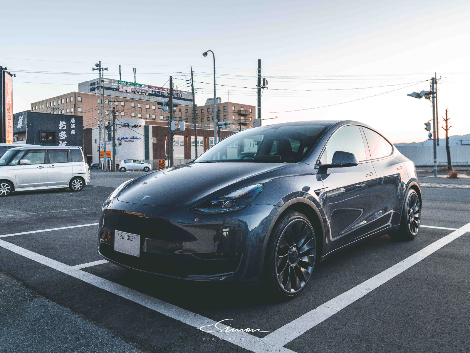
    This Model Y Performance was parked in a lot in Shinagawa. BOXIV leases several parking spaces long-term to store Teslas specifically for rental. In addition to the Model Y shown in the photos, I also spotted several Model 3s and refreshed Model Y units.

    Because it’s a fully contactless rental, all procedures are handled through the BOXIV app. First, you complete a pre-departure check in the app: walk around the car to inspect the body for scratches. If there are any scratches not already recorded in the system, you need to take photos and upload them for documentation. Once the check is complete, you can unlock the vehicle directly via the app.

    After getting into the car, there’s a key card placed in the center armrest, along with a printed instruction sheet for users to review. The armrest also contains a power adapter for voltage conversion when using public charging stations.

    Since Tesla’s infotainment system supports multiple languages (whereas most Japanese in-car systems only offer Japanese and English), I immediately switched the interface to Simplified Chinese. From the screen, I could see that this Model Y had already driven over 100,000 kilometers, and even with 85% battery remaining, the estimated range was only 354 km.

    This tea wasn’t put there by us—and the bottle was still there when we returned the car 🤣

    The parking lot where the car was located is equipped with Panasonic chargers rather than Tesla Superchargers, so charging power is relatively limited. To avoid leaving the next renter with insufficient battery, BOXIV offers a charging discount policy: if you charge at a Tesla Supercharger and meet certain criteria, you can receive a few hundred yen off the rental fee.

    Setting Off for Shōsenkyō!

    The destination for our one-day trip was Shōsenkyō, a scenic spot located in Yamanashi Prefecture, just outside Tokyo. From Tokyo, it’s about a two-hour drive, covering roughly 138 kilometers. However, given this car’s limited range and our desire for a more relaxed itinerary, we decided to head to a Tesla Supercharger first, planning to enjoy lunch while charging.

    Red indicates Tesla Superchargers, gray indicates regular charging stations

    As of 2016, Tesla had installed more than 700 charging stations in Japan. While Japan’s land area is much smaller than China’s, 700 stations is still a very limited number for the country. From the Supercharger map on Tesla’s official website, it’s clear that Superchargers are relatively dense within Tokyo, but once you leave the city, they become few and far between.

    Take Yamanashi Prefecture, our destination, as an example: there is only a single Supercharger nearby. The map also shows two other charging stations—one in front of a restaurant and another in front of a hotel—but both offer power outputs of only around 10 kW, which can essentially be ignored.

    Yamanashi’s only Supercharger is located in front of an electronics store and consists of six charging stalls, supporting up to 130 kW charging. Before setting off, the estimated remaining battery upon arrival was 30%; in reality, we arrived with 35% remaining.

    After plugging in the charger, we headed to a nearby sushi restaurant for a meal, then stopped by a popular dessert shop in the area, where we ordered coffee and pudding and chatted while eating. BOXIV’s app allows you to check the battery level in real time, and by the time the battery was fully charged, it was just about time for us to head back.

    Shōsenkyō

    Shōsenkyō is located in the northern part of Kōfu City and is one of Yamanashi Prefecture’s most representative gorge landscapes. It is designated a national “Special Place of Scenic Beauty” and is often referred to as “Japan’s most beautiful gorge.” What makes the gorge so striking are the sheer cliffs formed by granite that has been carved by flowing water over long periods of time. Jagged rock formations stand side by side with clear streams, and the walking paths along the creek allow visitors to observe these geological changes up close.

    At the same time, the granite mountains around Shōsenkyō are known as the “birthplace of crystal,” so the area around the gorge is dotted with shops and workshops selling crystal products. Visitors can also take part in crystal polishing experiences and create their own crystal accessories.

    Overall, the Shōsenkyō route is relatively gentle and is a very popular hiking trail during the autumn foliage season. Deep within the valley along the route lies Sengataki Falls, one of Shōsenkyō’s most iconic waterfalls, which has been selected as one of the “Top 100 Waterfalls of Japan.” The name “Senga” (written with characters also used for Chang’e, the moon goddess from Chinese mythology) is borrowed here to evoke the waterfall’s cool, ethereal atmosphere.

    The waterfall has a drop of about 30 meters, with water cascading down the granite rock face. The valley walls are close on both sides, and standing on the viewing platform, you can feel the sheer force and presence of the falling water at close range.

    Along the walking path near the waterfall, you can also spot many coins. This stretch is known as the “One-Yen Road.” It’s said that the “tradition” of wedging coins into the cracks between stones here has been going on for over a decade. Staff from the scenic area regularly collect these coins and use the proceeds to purchase cleaning and maintenance supplies for the site.

    After a short hike, we took a ropeway up to the summit of Mount Rakanji. Although the elevation is only 1,058 meters, you can still look out from the top and see Mount Fuji in the distance. The weather that day was good, and Mount Fuji was clearly visible on the horizon.

    There aren’t any particularly famous attractions here, and since it wasn’t peak foliage season, there were relatively few visitors. We sat on a bench at the summit for quite a while, taking in the unobstructed view of the surrounding mountains.

    The wind rose up from the valley below, carrying a hint of coolness without being biting. The ridgelines layered one after another, their colors fading from specks of green nearby to softer browns in the distance, as if gently brushed over by mist.

    The Return Trip

    On the way back, we also tried out the automated driving currently available in Japan. Unfortunately, the experience was not very good. While it was still daylight, the Tesla failed to correctly detect road barriers at a turn and headed straight toward them without hesitation. Thankfully, human intervention came in time, and no accident occurred.

    At night, the highway portion was something the Tesla handled with relative ease, requiring almost no manual intervention. That said, this isn’t particularly worthy of praise—based on my three years of driving experience, almost all Nissan models can achieve a similar level of performance on highways.

    Before returning the car, we stopped by a Supercharger near Shinagawa to top up the battery. This Supercharger is located in the underground parking garage of a large commercial complex and offers charging speeds of up to 240 kW. However, since parking fees apply after 30 minutes, the optimal choice is to finish charging and leave within that half-hour window.

    Returning the car was also handled entirely through the app. You need to take and upload 12 photos of the vehicle from different angles, confirm whether there are any new bumps or scratches, plug the car into the parking lot’s built-in charger, and finally lock the car to complete the return process.

    Conclusion

    At present, in order to promote electric vehicles, Japan has introduced a series of subsidy policies in 2026. Taking the Model Y as an example, if all subsidy requirements are met, it can be purchased for around 4.3 million yen (approximately 190,000 RMB). Combined with Tesla’s five-year zero-interest financing, this is indeed attractive to many white-collar buyers considering a new car.

    However, based on this one-day experience, I found that there are still quite a few “issues” with driving a Tesla in Japan today. The first is the distribution of charging infrastructure. As mentioned at the beginning of this article, once you leave the Tokyo metropolitan area, the number of charging stations drops sharply. From the charging map, it’s clear that regions such as Shikoku and Kyushu have very few Superchargers. While CHAdeMO or J1772 chargers can also be used, charging speeds are often difficult to guarantee.

    Second, electricity at these charging stations is not cheap. Based on feedback from Japanese users, electricity prices average around 30–55 yen per kWh. Coupled with the fact that Tesla’s driver assistance features in Japan are still fairly underwhelming, this makes the proposition less suitable for most people.

    Taking all of these factors together, I feel that “driving a Tesla in Japan” is better suited to commuting between cities when you have stable charging conditions at home, a clear daily route, and only take short trips on weekends without too much anxiety. Teslas are more ideal for those living in detached houses with parking spaces that can accommodate home chargers, or even with rooftop solar panels. You plug in when you get home, let it charge slowly overnight, and head out the next day with a full battery. Combined with Japan’s common “work during the day, return home at night” rhythm, the car can almost always operate within a personally controlled charging ecosystem. If solar power can cover part of the electricity usage, or if paired with battery storage to shift peak and off-peak loads, both costs and peace of mind become easier to manage.

    To be fair, EVs like Tesla have many advantages over most traditional gasoline cars in Japan: quicker acceleration, easier operation, and a higher level of intelligence. Yet this brief Tesla experience made it easier to understand why Japan continues to move more steadily with gasoline and hybrid vehicles. As long as the certainty around EVs isn’t strong enough, pure electric cars are unlikely to become a “no-brainer choice.”

    Teslas work quite smoothly in cities like Tokyo and Osaka, but once you leave these resource-dense urban areas, many issues quickly become magnified. For people who see a car primarily as a “tool,” the most ideal scenario is still charging at home, rather than charging on the road.

  • City Walk Guide:Exploring Jinan, China’s Rising Software Hub

    City Walk Guide:Exploring Jinan, China’s Rising Software Hub

    Another new weekend trip! This time, I came to Jinan, Shandong. During the peak of summer, I kept seeing posts about springs in Jinan bubbling up nonstop—so much so that even spring mouths that hadn’t flowed for years started “gurgling” again. Walking through Jinan’s old city, I really did feel that so-called “Little Jiangnan” vibe, and at times I even found myself momentarily thinking I’d arrived in Lijiang.

    Later, after looking up some background, I realized that Jinan is also known as one of China’s “software hub cities.” Digging a bit deeper, I found that the well-known Inspur Group was actually born here.

    Another Weekend

    This is my second weekend city trip. Earlier, at the beginning of the year after pandemic restrictions were lifted in 2023, I spent some time traveling around. By the end of that stretch, I was completely worn out and couldn’t muster any enthusiasm, resting all the way until the May Day holiday before I finally recovered.

    This time, the main idea was to simulate what life might look like after a major deadline passes. Beyond that point, I expect to spend a fairly long period drifting between different places around the world—though I’ll probably focus on China first. Beyond wanting to better understand my own country, I also want to take a closer look at the people living across this vast land.

    Choosing Jinan this time was entirely because of what I mentioned at the beginning: throughout the summer, I kept seeing stories about many of Jinan’s springs returning to life. Even springs that had been dry for years began to gush again, with water sometimes spilling out onto the streets. I had never really seen springs bubbling up like that. I’d passed through Jinan several times on high-speed trains heading south from Jinan West Station without ever stopping. This time, I decided to properly experience the character of the City of Springs.

    Departing from Beijing South Railway Station and heading south, we encountered waves of dense fog just after passing Fangshan. At first, the fog wasn’t too heavy—you could still see hints of blue sky above. As the high-speed train pushed deeper into Hebei Province, the fog grew thicker and thicker. It started as a vague sense of haze rolling in, then distant scenery became unclear, and eventually even the railway barriers outside the window blurred into obscurity. The scene brought back memories of my first trip south to Wuhan at the end of 2016 for a competition—also on a high-speed train, also wrapped in the same kind of fog. The only difference was that back then there was an acrid smell in the air as well. It became so unbearable that I had to sit there wearing a mask, creating a strangely surreal image.

    After checking the weather, I realized that every autumn and winter, whenever there’s windless weather without air circulation, this vast stretch of the Hebei Plain inevitably fills with heavy fog. Combined with emissions from numerous industrial zones, fuel use, and burning within the province, scenes like the one I witnessed can appear with very little warning.

    Originally, I was quite sleepy after boarding—after all, it was a high-speed train just after 8 a.m. But staring out at the thick haze outside the window, my thoughts slowly began to drift.

    Jinan Old City

    It was close to 10 a.m. when I arrived at Jinan West Railway Station.

    The weather in Jinan was quite pleasant, completely unaffected by the heavy smog that blanketed parts of Hebei. When the weather still hadn’t improved after entering Dezhou, Shandong, I was actually worried that this trip might end up unfolding in thick fog. Thankfully, it didn’t affect Jinan at all.

    Perhaps because my recent weekend trips have all been to nearby provincial capitals, I felt that prices in Jinan weren’t exactly low either. To avoid affecting my sleep after a full day of walking, I chose a Nihao Hotel under the Huazhu Group. While it can’t really be compared with the Ji Hotel series, the price still came in around RMB 240, which stung a little. The only consolation was its decent location—about 200 meters south of Quancheng Square in the Jinan old city area. Check-in was immediate, no waiting at all, and after seeing the room, I reached a conclusion: my standards for hotels could probably be set even lower in the future.

    Quancheng Square itself is fairly typical—nothing out of the ordinary for a city plaza. There’s the usual square dancing, the equally familiar sunken commercial street, and even matchmaking notices. I took a closer look at those notices: the conditions listed were all quite good, hobbies sounded nice, everyone was young—mostly born in ’92 or ’93—with monthly salaries around seven or eight thousand yuan, and many were in popular professions like civil servants or teachers. The more I read, the more I felt I didn’t quite belong there. Thinking in terms of the traditional idea of “matching social status,” finding a suitable pair these days really does seem difficult.

    To the west of Quancheng Square lies Baotu Spring. Walking toward the south gate, you can see from afar how the spring draws in crowds like a black hole—clearly packed with visitors. The ticket costs RMB 40, and overall it didn’t feel expensive. Apart from the small area right around the main spring that was extremely crowded, the rest of the park was fairly comfortable. To attract visitors, large numbers of koi have been released into the water. I’d seen frequent security reminders lately telling people to stop feeding the fish—they’ve grown so fat they can barely swim. As for such a fragile natural landmark that has existed for so long, the Jinan government must be providing significant subsidies to preserve this “Best Spring Under Heaven.” Otherwise, it’s entirely possible that our generation might not get to see it at all.

    Baotu Spring Park features extensive classical garden landscaping. Strolling slowly, you’ll unexpectedly come across sunlight pouring onto the lake surface, illuminating the aquatic plants and koi below. That blend of red and green layers the beauty of Baotu Spring across history. I found myself repeatedly sitting by one pond, then another. During this time, I noticed that most visitors seemed unable to truly slow down and “appreciate” what was in front of them. What I heard most were remarks like “Wow, that fish is huge,” “This water is so clear,” or “This view is nice.” I wanted to see what they’d do next with those exclamations, but in reality, people just snapped a quick photo or commented while walking, then moved on.

    Thinking back, I realized I’ve rarely had this kind of “passing by” mindset. Maybe it’s because I didn’t travel much growing up, and only began to gradually engage with the real world after university and entering society. Or perhaps others are simply accustomed to such scenes and don’t feel they’re particularly special. To me, though, it feels like a pity. We could have gone further—explored where the beauty comes from, why it’s beautiful, and how it makes us feel. Over time, we’d develop our own way of perceiving and experiencing beauty. Taken further, that’s how a collective or even a national aesthetic emerges.

    We do have aesthetics, but they’re often too abstract. On an individual level, most people don’t really know what “beauty” is. I only came to understand it after taking a long detour through photography in recent years, constantly wanting my photos to have more depth and visual appeal. I don’t chase the decisive moment, but I do want a single image to express something—and that requires a perception and understanding of beauty.

    There’s a boat pier at Baotu Spring’s north gate. I was puzzled why no one was lining up, until I asked and learned that all boat tickets—from Baotu Spring and even across the entire old city waterways—were sold out for the day. These are boats that run through the old city canals, not the kind found inside parks.

    Slightly disappointed, I exited the park. Right across from the north gate is Five Dragon Pool, but I was still savoring Baotu Spring and didn’t want to jump too quickly to another spring. Spotting a very popular Shandong cuisine restaurant nearby, I took a number—only to find that even dining solo meant waiting behind nine tables, likely over an hour. After some thought, I decided to delay lunch and head to Five Dragon Pool first.

    Compared with Baotu Spring, Five Dragon Pool has far fewer visitors. While its springs aren’t as bold or dramatic, if you’re not fixated on gushing water and simply want to understand what springs are like, this spot—just across the street—is an excellent alternative.

    Inside Five Dragon Pool is a large lake. If you’re not in a hurry, you could easily spend half an hour there with a bowl of tea. I don’t have much interest in tea, and I prefer observing dynamic springs from multiple angles rather than sitting still, so I skipped it. The park is free, and there are many shallow water areas where children can play. The water quality feels far more reassuring than that of water parks or even swimming pools. I saw several kids barefoot in the water, and even smaller ones lying right in it.

    That said, Jinan in autumn already carries a slight chill—it’s easy to imagine how lively Five Dragon Pool must be in summer.

    I didn’t stay long—less than an hour—mostly because I was getting hungry. The original plan was to casually find a place to eat along the road toward Daming Lake, but restaurants were surprisingly sparse. One place I finally found was already packed; I stood there for a while without any staff approaching, so I left to keep searching. Eventually, I settled on a restaurant that looked relatively upscale and ordered several signature dishes: braised pork (ba zi rou), nine-turn intestines, sweet-and-sour yellow croaker, and milky soup cattail.

    In reality, only the braised pork was genuinely delicious. The much-anticipated nine-turn intestines were shockingly bad. I couldn’t tell whether that sweet, funky flavor was authentic or just poorly done. There were nine pieces in a small clay pot—an expensive dish—and I forced myself to eat all but the last one. The final bite nearly made me spit everything out. Safe to say, I won’t be ordering it again. The sweet-and-sour fish arrived with a strange sour smell—almost like foot odor—that lingered even after the server paused for five seconds to ask if I wanted a photo. I’d always thought vinegar had a distinctive, appetite-opening aroma, not this unpleasant sourness.

    I did manage to finish most of the food, but paying RMB 291 for four dishes and a bowl of rice left me feeling deeply dissatisfied. If anyone out there can change my mind about Shandong cuisine, I’m all ears—otherwise I may be avoiding it in the future. After leaving the restaurant, my stomach felt unwell—not nausea, but that uncomfortable feeling of having eaten something wrong. Walking around Daming Lake for over half an hour and drinking lots of water eventually helped.

    Daming Lake is just a short walk from the restaurant. My initial impression of it had always been limited to the phrase “Xia Yuhé by Daming Lake,” without even knowing its origin. I used to think it referred to a real story involving Emperor Qianlong, but it turns out it was entirely fictional, from My Fair Princess—quite embarrassing.

    Daming Lake is indeed large—comparable in size to the Summer Palace, in my opinion. But unlike the Summer Palace, which always feels like a whole event to visit, Daming Lake feels far more approachable, like a casual post-meal stroll.

    The lake stretches east to west, with Chaoran Tower at the eastern end, offering views over the city. I originally planned to climb it, but with a visit to Thousand Buddha Mountain scheduled for the next day, I decided against it. Beyond the expansive water, there’s extensive landscaping on land as well. Wandering among pavilions, bridges, and flowing water, it’s a lovely place to walk—though the crowds make it hard to quietly reflect on the lake’s history.

    I entered through the south gate, walked a full loop, and exited near the same area, crossing over to Qushuiting Street—the true heart of Jinan’s old city.

    This area strongly evokes the feel of a southern water town. Paired with small bars along the road, it genuinely resembles Lijiang, which explains why Jinan is sometimes called “Little Jiangnan.” The further south you go on Qushuiting Street, the more enchanting it becomes. Visiting on a weekday or during the off-season would be incredibly relaxing. Unfortunately, today there were far too many people in traditional costumes doing photoshoots—nearly every decent corner was occupied, making the experience less enjoyable. I can only hope to return at a better time.

    Continuing south toward Furong Street brings you to one of the old city’s snack streets—the first I encountered that day. Back in my middle and high school years, I loved snack streets so much that I’d ride over an hour by bus from the suburbs just to eat. Back then, there weren’t many snack streets, and the food reflected regional diversity. Being able to eat Guilin rice noodles in the south felt like a real treat.

    By the time I reached university, everything seemed to accelerate. Nearly every city, regardless of size, now has a snack street. That’s not necessarily bad, but over time, they’ve all become identical—no local character, just copy-and-paste.

    I understand this as a result of commercialization and market forces. But as a traveler, I hope to experience a city’s uniqueness—especially through food. Cuisine is often the most direct way to feel what makes a place different, and getting that right can elevate the entire travel experience.

    I quickly passed through the packed snack stalls of Furong Street, enduring the overpowering smells of grilled squid and stinky tofu, until I reached the moat. Jinan’s moat isn’t as imposing as Beijing’s; instead, it has a gentler charm. If you had to find a similar spot in Beijing, the Liangma River near Dongzhimen comes close. Walking south along the moat eventually leads to Black Tiger Spring. The path there was quiet, with only a few people around. Despite it being late autumn, it didn’t feel cold at all—just comfortably moist in the air. Near the Black Tiger Spring boat pier, though, the crowds returned.

    Black Tiger Spring actually consists of three separate springs in the southwest corner of the old city, with Black Tiger Spring itself boasting the largest flow. Water gushes from a small hill behind the outlet at over 400 liters per second, second only to Baotu Spring. What’s more interesting is the number of locals lining up with buckets to collect spring water. The government has even installed QR-code-operated drinking water facilities nearby. I considered filling a bottle myself, but seeing the queues, I gave up.

    Black Tiger Spring is highly recommended—its combination of springs and moat creates a landscape entirely different from Baotu Spring or Daming Lake, well worth a visit.

    As evening fell, I continued north along the moat and detoured to Kuanhouli, only to find it was yet another snack street. To avoid smelling like squid and stinky tofu again, I quickly found the nearest exit. By the road, I spotted Jinan’s distinctive “flower carts”—tricycles decorated with pink lights and artificial petals, giving the street a Southeast Asian vibe. Looking into it later, I found controversies around illegal operations and overcharging tourists, especially during holidays. While traffic violations are an issue, I don’t fully agree with the other criticisms. If demand remains strong despite bans, perhaps the better approach is to regulate and legitimize them—turning Jinan’s flower carts into a true city symbol rather than extinguishing them. That’s exactly what makes a city unique.

    Afterward, I stopped by Jinan Hang Lung Plaza and got to try the iPhone Air. It’s genuinely impressive—the kind of device that makes you want to buy it the moment you touch it. The last time I felt that was with the iPhone 12 Pro series. I even bought an iPhone 12 mini back then, hoping to recapture the feel of the iPhone 4, but returned it after one weekend. Looking back, that feels like a real loss—the mini line is now gone, and worth keeping if budget allows. I also asked, half-hopeful, about the new dual-loop knitted strap for Vision Pro. A staff member initially said it was in stock, which got me excited, but it turned out there was no inventory. On the Apple Store app, delivery now takes a month. The dual-loop strap really is better—less facial pressure than previous designs, and well worth buying.

    And with that, my first day in Jinan ended around 6 p.m. I returned to the hotel early. My stomach was still uneasy from lunch, so I bought two cartons of milk and a corn from a convenience store and called it a night.

    Thousand Buddha Mountain

    On the second day, I originally planned to wake up early, hike Thousand Buddha Mountain in the morning, and head to the museum in the afternoon. I set an alarm for 7:30, but somehow dragged it out until 9 before I even went to eat breakfast, and it was nearly 10 by the time I arrived at Thousand Buddha Mountain. As luck would have it, I ran straight into the Double Ninth Festival hiking event on the ninth day of the ninth lunar month. Compared with Baotu Spring yesterday, the crowd here was several times larger—everyone was jammed onto the climbing paths.

    Before the “official” hike begins, the approach road is actually quite wide, but both sides were lined with vendors selling everything imaginable. From what I saw, most were selling mountain goods, local specialties, and folk handicrafts—honestly far more interesting than wandering a snack street. There was even a troupe performing something that looked very much like a model opera, with a sea of uncles and aunties sitting below. It felt a bit like the rural northern village stages I’d imagined—people gathered to watch a show.

    Before you start climbing in earnest, you pass through an extra ticketed inner attraction called “Four Caves, Ten Thousand Visions.” Of China’s four great grottoes, I’ve visited all except the Maijishan Grottoes, and even so, I still think this one is worth it. “Four Caves, Ten Thousand Visions” is like a highly condensed presentation of the essence of Chinese grotto and stone-carving culture. Some pieces are 1:1 reproductions, others scaled—big and small, heavenly and earthly, everything you could want. If you’ve never experienced grotto art before, or never seen the real “four great grottoes,” you should come here even more—it’s a perfect place to build a first impression, and it will absolutely leave you stunned.

    Also, I originally thought it would just be a short stretch—walk in, walk out, done. But once inside, I found myself exclaiming along with everyone else: “Huh? There’s more? You can go even deeper?” I heard that in summer, the temperature inside the caves stays at 18°C, and you can rent a blanket at the ticket counter before entering. Just imagining that felt exciting.

    Thousand Buddha Mountain is one of Jinan’s three major scenic attractions. It isn’t tall at all—so easy to climb you barely need to lift your heels. But there were simply too many people. And since the summit area itself isn’t large, once you reach the top there isn’t much space to pause and really take in the view. In ancient times, people would climb high and look far, and their hearts would feel open and refreshed. Today, when we climb high and look far, it’s all noise and crowds—hard to find an environment where you can truly settle down and feel anything. Still, the skyline of Jinan’s CBD off to the northwest did look quite good. Only after I got home and looked things up did I realize Jinan is actually known as one of China’s software hub cities. And when I looked closer—turns out the famous Inspur Technologies was born in Jinan, and there’s even a road named “Inspur Road.”

    By the time I reached the top, it was almost noon. I wasn’t that hungry yet. After weaving left and right through the endless stream of people still trying to climb up, I finally made it onto a ride to the Shandong Museum just after 12. I didn’t expect Jinan’s weather to be too good lately—so many people were out, so many cars on the road. I got in the car just after 12, yet it was nearly 1 p.m. by the time I stepped into the museum. I could only speed up my visit.

    Museum

    The moment I entered the Shandong Museum, I was stunned. The soaring atrium design creates a grand, monumental “Shandong” impression. Embedded high up on the ceiling—four or five floors above—was a massive version of the museum’s signature treasure: the large Lu-state jade bi disc. Later, after seeing the actual jade bi disc on display, I realized the one in the ceiling must be hundreds of times larger than the real object. It was genuinely overwhelming.

    Maybe I still hadn’t fully stepped out of last week’s visit to the Hebei Museum, because after arriving at the Shandong Museum, the exhibits and curatorial approach felt comparatively ordinary—almost “normal.” After seeing several of the museum’s headline treasures, I didn’t feel that same shock or sense of exquisite craftsmanship; some even felt a little like they were there just to fill space. But looking back now and reconsidering the Shandong Museum’s curation and collections, I still have to say it’s a top-tier museum: richer exhibition resources than the Hebei Museum, three floors with 15 exhibition halls in total—nearly double Hebei’s nine. And at the time, I was fixated on seeing only the highlights, constantly worried about not missing my high-speed train back to Beijing. I skimmed past a lot of exhibition text without really reading it. In the end, I spent only about an hour covering a few key halls, and I didn’t even have time for many interesting temporary exhibitions.

    Next time, I need to set aside at least half a day—maybe more—for a provincial museum. I absolutely can’t rush it like I did this time.

    What’s even funnier is that I rushed through the museum, and when I came out, it was only around 2 p.m. I figured I might as well head to the nearby MixC, eat a proper lunch, then go to the station. I wandered around, searched as I went, and eventually ended up having Coucou Hotpot—plus I even chose the all-you-can-eat set. I ate while waiting for the dishes, then slowly worked through fruit and scrolled on my phone. By the time I paid and left MixC to grab a taxi to Jinan West Station, I saw the estimated time was 51 minutes—and my brain just blanked. It was 3:10 p.m. At that point I hadn’t even reached the roadside pickup area yet. Even if I got into a car immediately, I’d have only 19 minutes left upon arrival to clear security and boarding—and if traffic got any worse, I’d miss the train outright.

    Once in the car, I made the call on the spot and rebooked. I pushed it back by 40 minutes and was forced to pay an extra 100 yuan for first class just to fix the situation. In other words: I didn’t get to enjoy the museum properly, I ate in a panic anyway, I messed up my schedule, paid more, and got home later. After all that, what was the point? I should’ve just gone straight from the museum to the station and eaten there. Even more absurd: the entire second floor of Jinan West Station is basically food—no lines. From finishing security to sitting down takes five minutes.

    Sitting on the high-speed train back to Beijing, I reflected on the chaos and came away with a few lessons. First: don’t try to cram too much in. A weekend trip is barely a day and a half—already tight. If you insist on seeing this, doing that, hopping back and forth, it’s easy for things not to connect, and then everything after gets affected. Second: if you’ve decided to go and see something—then in that moment, you should be steady and grounded. Look carefully, think carefully. Stop worrying about what comes next. Worst case, you handle what’s in front of you well, and you let the rest go. If you’re doing one thing, then do it well.

    Lastly: my sense of risk control still wasn’t strong enough. I always push risks to “later.” Sure, sometimes thinking too far ahead is useless—but for something that’s going to happen in just a few hours, it’s still good to plan ahead a little.

    Conclusion

    Jinan really is a good place. Compared with Shijiazhuang, I personally find it more livable: it has water and mountains, culture and history, depth and character. It even boasts high-tech industries that many cities envy. Most importantly, the overall quality of the population feels higher—after all, this is the provincial capital of a region where Confucian and Mencian thought has long flourished.

    My original plan for this area was to climb Mount Tai first and then come to Jinan, but arranged that way, years went by without it ever happening. No matter how you slice it, that kind of itinerary needs at least two full days, which actually fits my idea of a weekend trip quite well.

    Setting aside Qingdao and Weihai, this is already my third city in Shandong. Who knows when I’ll next make a dedicated trip to the province again. I’ve talked with a few friends about it—this recent stretch of travel marks what I see as my third phase. The first phase began in 2023, after pandemic restrictions ended. It was also mostly weekend trips, sometimes taking an extra day off, focusing on classic, well-known cities around Beijing—Datong, Hohhot, Luoyang, Dalian—specifically to see historical sites. The second phase started in 2024 and continues to this day: traveling abroad, taking bigger steps, wanting to personally experience different cultures, different narratives, and different people and stories.

    Now I’ve reached the third phase. After going through the first and second phases, I haven’t grown tired—on the contrary, I feel even more curious about the world around me. I want to pay attention to ordinary people and small things, to go to smaller places—places like Jixian near Tianjin, Nanchang, or Kashgar—less famous than some of the cities I’ve visited before. This phase will continue for quite some time, and if opportunities arise, I’ll go to even more small places.

    Beyond that, there’s a fourth phase I want even more. I want to walk freely across the land of China. There’s a book called China on the Earth, a landmark work of travel literature. In 1986, its author Paul Theroux traveled by train through more than twenty provinces and cities in China, recording what he saw and experienced, presenting the social changes of China in the early years of reform and opening up. I’d love to do something similar—but I don’t want to approach it from a grand, sweeping perspective. I just want to see the big figures and small figures living on this red earth, to visit these cities, large and small.

    I don’t know when that day will come—but I have a feeling it might not be too far away.

  • When the End of the World Becomes a Trending Topic: A Guide to Traveling to Antarctica

    When the End of the World Becomes a Trending Topic: A Guide to Traveling to Antarctica

    Antarctica doesn’t often appear on the Chinese internet’s trending lists. Its most recent appearance, however, was rather unusual—sparked by an internal letter sent by a well-known company founder during a trip to Antarctica.

    Glaciers, penguins, and the polar day were suddenly placed in the same public arena as overtime, KPIs, and annual performance reviews. Naturally, people interpreted the situation in different ways. “The boss is at the end of the world, while employees are stuck at their desks” was the first reaction for many after reading that company-wide email. But for others, it was the first time they realized that Antarctica is no longer just a scene from documentaries—it’s a real place that can be “consumed” as a travel destination.

    For example, my partner. Her preferred vacation destination for next year has already shifted from Japan to Antarctica. I strongly suspect this incident had something to do with it. Following the principle of “she proposes, I execute,” I had to start digging into the details and figure out how “going to Antarctica” actually works. First comes the feasibility study, then a proper project plan. As for whether it will really happen next year—that depends entirely on how cooperative my wallet decides to be.

    This article isn’t meant to judge that letter, nor to discuss corporate management. It’s simply trying to do one thing: clearly explain what Antarctic travel itself is all about.

    When we talk about “going to Antarctica” today, what are we actually talking about?

    Who Governs Antarctica?

    Let’s start by clearing up a basic fact: Antarctica is not a country, and it does not belong to any country. It is the only place in the world that falls outside the sovereignty of any nation.

    Between 1908 and 1941, the United Kingdom, Australia, New Zealand, France, Norway, Chile, and Argentina successively made territorial claims over Antarctica.

    Antarctic research stations and territorial claims map (2015)

    Based on the so-called “sector principle,” these seven countries took the South Pole as the apex, used meridians and parallels as boundaries, and drew sectors whose bases were defined by a country’s coastline or a specific latitude. The resulting wedge-shaped areas became their claimed territories. In this way, the combined claims of the seven countries covered more than 80% of the Antarctic continent.

    However, the international community did not recognize these sovereignty claims, instead calling for Antarctica to be regarded as the “common heritage of all humankind.” That stance is easy to understand. Still, the seven claimant countries and the rest of the world could not reach a consensus. As a result, on December 1, 1959, Argentina, Australia, Belgium, Chile, France, Japan, New Zealand, Norway, South Africa, the Soviet Union, the United Kingdom, and the United States signed the Antarctic Treaty, temporarily setting aside the issue of sovereignty.

    The Antarctic Treaty, signed in 1959 and entering into force in 19611, established several fundamental principles for Antarctica:

    • Use exclusively for peaceful purposes;
    • Priority given to scientific research;
    • A freeze on all sovereignty claims;
    • A ban on military activities and nuclear testing.

    Today, the treaty has 50 member states, including 28 consultative parties and 22 non-consultative parties. As for the territorial claims made by the seven consultative parties, the remaining 43 member states neither recognize those claims nor have they put forward claims of their own.

    Thankfully, no one recognizes the seven countries’ demands—otherwise, traveling to Antarctica might require a U.S. visa, and diplomats could end up being posted to the South Pole. Still, even though there’s no passport stamp on entry, Antarctica is far from a free-for-all “no man’s land.”

    Antarctica today is a highly institutionalized and tightly managed space. Almost all legitimate Antarctic tourism activities must be conducted through companies that are members of IAATO (the International Association of Antarctica Tour Operators)2. Operators are responsible for managing visitor behavior, limiting landings, protecting the environment, and ensuring emergency evacuation capabilities.

    Who Goes to Antarctica?

    Many people assume that traveling to Antarctica is reserved for a tiny group of explorers, but that reality has changed dramatically.

    In the late 19th century, Antarctica truly was the last undeveloped continent on Earth. Whalers and seal hunters were likely the first humans to set foot on the Antarctic continent in search of opportunity. In the early 20th century, countries such as Japan, Germany, the United Kingdom, Sweden, and Norway all launched plans to explore Antarctica, and competition among them was at times extremely fierce.

    On December 14, 1911, a five-man expedition led by Norwegian polar explorer Roald Amundsen reached the South Pole, becoming the first team in human history to do so3. Just over a month later, on January 17, 1912, a five-man party led by British explorer Robert Falcon Scott arrived at the South Pole, only a little more than 30 days behind Amundsen4. The two men even visited each other’s ships at the time. Some readers might be interested in the stories of these two legendary figures—perhaps I’ll write about them in a separate piece someday.

    Today, the 29 consultative parties to the Antarctic Treaty operate 70 permanent research stations on the continent, while tourism around Antarctica began as early as the late 1950s. Over the past two decades, the number of Antarctic tourists has continued to grow—from just a few thousand per year in the early days to tens of thousands annually in recent years (with a temporary interruption during the pandemic). Most visitors come from Europe, North America, Australia and New Zealand, as well as Asia, where growth has been particularly noticeable in recent years. According to data from the International Association of Antarctica Tour Operators, in the pre-pandemic 2018–2019 season, 56,000 people traveled to Antarctica, with the largest number coming from the United States and the second-largest from China.

    The reasons behind this growth are not hard to understand.

    It is now 2025 (editor’s note: referring to the time of writing), and traditional “end-of-the-world” destinations have largely been developed. Whether it’s Machu Picchu, Easter Island, or even tourism within the Arctic Circle, these places are no longer rare. Prices for such destinations have been driven down significantly—I can even find Machu Picchu tour packages for just a few thousand yuan on platforms like Ctrip or Fliggy. For middle- and high-income groups, there is a clear desire for “non-replicable experiences.” Perhaps this also contains an element of what The Theory of the Leisure Class describes as “conspicuous consumption.”

    People’s growing desire for better travel experiences—and for producing truly unique photos to post on social media—has come into direct conflict with the limited capacity of Antarctic cruise ship berths.

    Although the cruise industry and polar equipment have become highly mature, and expedition ships are no longer the life-or-death gamble they were in the 19th century, Antarctica is still subject to numerous treaties that cap visitor numbers at a relatively low level. Even though tens of thousands of people now visit each year, that figure may still be lower than the single-day foot traffic at some popular national holiday attractions. I’m looking at you, Shanghai Disneyland.5

    Antarctica has shifted from an “exploration narrative” to a form of symbolic consumption. It symbolizes freedom of time, freedom of resources, and the act of “having been there” in an extreme environment.

    That said, I’m not criticizing consumption. On the contrary, I think consumption can be a good thing.

    The importance of tourism to Antarctica is self-evident. Carefully controlled tourism is not only unproblematic, but can be genuinely beneficial. Antarctica has no indigenous population to advocate on its behalf—it needs people to speak for it. Tourism can help build a global community that is willing to support and fund the protection of Antarctica. Many people have probably seen that iconic photo of a polar bear standing on a piece of floating ice. My view, shared by many others, is this: compared with being ignored entirely, a certain degree of responsible tourism is the better option.

    How Do You Go About It?

    Timing Window

    Antarctic tourism is only open during the Southern Hemisphere summer, typically from November to March of the following year. During the rest of the year, Antarctica enters a period of polar night, extreme cold, and extensive ice formation. Sea ice closes in, winds become uncontrollable, and the region is virtually unsuitable for any commercial navigation or landings.

    Even within this short five-month window, the experience varies significantly by month:

    November marks the transition from Antarctic spring into early summer, when the season is just beginning. Temperatures range from about −2°C to −1°C, with 18–21 hours of daylight. At this time, ice coverage remains thick and sea ice is dense, making the overall scenery closest to what many people imagine Antarctica to look like. However, wildlife activity is relatively limited: penguins have not yet entered their most active breeding phase, and landing site options are more restricted.

    As a result, prices in November are generally more affordable, with a slight increase in December.

    December to January is the peak season for Antarctic travel. Temperatures hover around 0.3°C to 0.5°C, with 16–20 hours of daylight. This is when Antarctica enters the polar day period, with nearly 24 hours of sunlight. Conditions are relatively mild, and penguins are in their nesting, incubation, and chick-rearing stages, making it the best time for wildlife observation. Most first-time visitors to Antarctica choose this window.

    From February to March, Antarctica takes on a different character. Ice begins to melt, improving maritime access and making conditions more flexible for zodiac cruises and photography. Juvenile penguins gradually grow, while adults begin taking their chicks out to sea. Whale sightings become more frequent, offering a richer visual experience. Late March is considered the prime time for whale photography.

    Routes

    Getting to Antarctica isn’t as simple as buying a plane ticket, the way you would for Iceland or Alaska.

    I usually break the journey into three segments. The first is flying from China to Argentina or Chile. The second is traveling from those countries’ major cities to the Antarctic gateway ports. The third leg is the journey from a sovereign country to Antarctica itself. In practice, most Antarctic trips rely primarily on sea routes, meaning you’ll be traveling by ship.

    Flying from China to Argentina or Chile

    Aside from China Eastern’s direct route from Shanghai (with a stopover in Auckland) to Buenos Aires, there are currently no other nonstop flights from China to Argentina or Chile. In most cases, you’ll need at least one connection to reach Buenos Aires (Argentina’s capital) or Santiago (Chile’s capital), and then take another flight to Ushuaia or Punta Arenas.

    China Eastern’s quasi-direct flight typically costs over RMB 20,000 round trip, and it’s unclear whether there will be significant discounts in the future.

    With some patience and luck, connecting flights can be much cheaper. However, many transit routes require transit visas, so preparation in advance is essential. That said, if you’re already planning a trip to Antarctica, visas are probably not your biggest concern.

    It’s also worth noting that on July 21, 2025, the Argentine government announced that Chinese passport holders with a valid U.S. visa can enter Argentina visa-free for up to 30 days. 6In other words, if you have a B1/B2 U.S. visa, you can enter both Chile and Argentina without applying for separate visas. If you overstay, you can either apply for an extension at immigration or pay a fine upon exit, without affecting future entries to Argentina.

    Based on my experience, it’s best to book international flights and South American domestic flights separately. This approach usually offers two practical advantages. First, splitting the tickets often results in a lower overall price. Second, it gives you greater flexibility, making it easier to add side trips within South America—such as Buenos Aires, Perito Moreno Glacier, Iguazú Falls, or even extending the trip to Torres del Paine in Chile or Peru.

    In real-world searches, round-trip international tickets from Beijing to Buenos Aires can often be found in the RMB 10,000–14,000 range if you monitor prices in advance, including options from higher-quality carriers like Turkish Airlines and Emirates.

    Once your Antarctic cruise dates are confirmed, it’s advisable to start watching international airfare trends right away. If you see prices that are clearly below the norm, that’s usually the time to buy. In general, I wouldn’t recommend waiting until less than a month before departure to book long-haul flights. The same applies to domestic flights within Argentina—booking early not only saves money, but also makes it easier to find flight times that connect smoothly.

    From International Cities to Antarctic Port Cities

    Whether you choose Ushuaia in Argentina or Punta Arenas in Chile as your embarkation port, the basic flight-planning logic is very similar. You’ll fly from Buenos Aires to Ushuaia, or from Santiago to Punta Arenas.

    One critical detail to watch out for is Buenos Aires’ airport layout. Ministro Pistarini International Airport (Ezeiza) mainly handles international flights and is quite far from the city center. Aeroparque Jorge Newbery Airport, on the other hand, serves mostly domestic flights and is much closer to downtown. If possible, avoid switching between these two airports on the same day. If you must transfer between them due to time constraints, be sure to leave a generous buffer—at least five hours. During peak times, the commute alone between the two airports can take more than three hours.

    Before boarding your Antarctic cruise, it’s highly recommended to reserve at least one buffer day in Ushuaia to account for flight cancellations, delays, or lost luggage. If you miss the ship due to upstream flight issues, there is usually no way to recover the cost of an expensive cruise ticket.

    The return journey also requires careful planning, since Antarctic cruises can be delayed when returning to port. Flights departing Ushuaia should ideally be scheduled after 11 a.m. International flights leaving Buenos Aires are best booked for the day after disembarkation. If time is truly tight, flights departing after 10 p.m. on the same day tend to carry a relatively manageable level of risk. As everyone knows, plans often struggle to keep up with reality.

    One more word of caution: be wary of the low-cost airline Flybondi. While its fares are cheap, flight cancellations and schedule changes are frequent. I have friends who received four schedule-change notifications from Flybondi in just three days. If your itinerary requires precise coordination with an Antarctic cruise or international flights—especially if you’re planning quick side trips—choosing a more reliable airline is usually the safer bet.

    If your South American journey extends beyond Antarctica, a more efficient approach is to book an open-jaw or multi-city ticket. For example, you could fly from China into Buenos Aires and return home from Lima or Santiago. This is often cheaper than buying two separate one-way tickets and also avoids unnecessary backtracking. Some European transfer routes (such as via Paris or Amsterdam) may require a Schengen visa, so be sure to check requirements in advance.

    From Argentina or Chile to Antarctica

    From Ushuaia in Argentina or Punta Arenas in Chile, there are generally two ways to reach Antarctica: a fly–cruise combination or a full voyage by ship.

    In recent years, a small number of high-end products have emerged that “fly over the Drake Passage,” taking passengers directly by plane to the Antarctic Peninsula before boarding a ship for activities. These options are more expensive, extremely limited in availability, and have not become mainstream. Antarctica21, for example, operates exclusively on a fly–cruise model.

    In simple terms, you fly across the Drake Passage and then board a ship near the Antarctic Peninsula. A two-hour flight replaces what would otherwise be two days of rough seas in the Drake Passage. However, flights to Antarctica are highly weather-dependent, and delays or cancellations are not uncommon. Across an entire Antarctic season, fewer than 10% of all visitors choose routes that include at least one flight.

    This model relies entirely on an extremely fragile logistics node: Teniente Rodolfo Marsh Martin Airport (IATA: TNM) on King George Island in the South Shetland Islands. In such a resource-constrained environment, flight windows are often measured in minutes. Flights are scarce, prices are higher than traditional ship-in/ship-out itineraries, and discounts are virtually nonexistent.

    A typical product is Antarctica21’s fly–cruise route, which departs from Punta Arenas in Chile, flies across the Drake Passage, and offers an 8–10 day itinerary, with prices starting at RMB 100,000–200,000.

    Wait—how did this start sounding like an advertisement for Antarctica21? To be fair, the company does claim to be the first in the world to pioneer fly–cruise Antarctic travel. They say so, and I believe them. I’m that easygoing as a consumer.

    Fly–cruise itineraries usually depart by plane from Punta Arenas and land at Chile’s Frei Station on King George Island in Antarctica. That means your flight-tracking app will record an exceptionally rare “Antarctica” check-in.

    Frei Station is Chile’s research station on King George Island, the largest island in the South Shetland Islands. The surrounding area hosts a dense cluster of international research stations, including China’s Great Wall Station7, Russia’s Bellingshausen Station, Uruguay’s Artigas Station, and South Korea’s King Sejong Station, making it one of Antarctica’s most concentrated scientific hubs.

    For the vast majority of travelers, however, a trip to Antarctica is fundamentally a voyage by sea.

    The most mainstream route today departs from the southernmost port cities of South America—most commonly Ushuaia in Argentina, or for some itineraries, Punta Arenas in Chile. Travelers board specialized polar expedition ships at the port, then cross the Drake Passage to reach the waters around the Antarctic Peninsula. This leg of the journey typically takes about two days.

    Before reaching the port city, tour operators may add stopovers in places like Santiago or Buenos Aires to raise the overall package price and increase margins.

    The Drake Passage, located between South America and Antarctica, is one of the roughest and most meteorologically unstable seas in the world. With no continental landmass to break the winds, the westerlies rage year-round, and wave heights can reach several meters or more. Ships inevitably endure constant rolling and pitching. For passengers, this often means prolonged physical discomfort, disrupted sleep, and a serious test of mental resilience.

    So promise me one thing: bring motion sickness medication. Antihistamines are the most common “seasickness pills” and are suitable for preventing mild to moderate motion sickness. They work by suppressing vestibular nerve signals to reduce dizziness and nausea, and are most effective when taken 30–60 minutes before sailing.

    Drug nameSuitable use
    Dimenhydrinate tablets (commonly used for motion sickness/seasickness)Suitable for people with mild or occasional motion sickness; some users may experience side effects such as drowsiness or dry mouth.
    Diphenhydramine tabletsHas antiemetic effects; adults can take it before departure. After taking it, avoid driving or performing tasks that require fine motor skills.
    Promethazine hydrochloride tabletsAlso a commonly used antihistamine that helps suppress motion sickness; should be taken according to the instructions or a doctor’s advice.

    These medications are widely available in pharmacies in China. You can simply ask the pharmacist for motion sickness or seasickness medication.

    Anticholinergic drugs are suitable for moderate to severe motion sickness. They work by blocking neurotransmitters such as acetylcholine, and are more effective for severe nausea and vomiting.

    Drug nameSuitable useNotes
    Scopolamine patchThis is a commonly used “patch-style seasickness patch” in China, usually applied to the skin behind the ear. Its effects typically last for dozens of hours. It should be applied about 4 hours in advance, making it suitable for long sea journeys or people who are prone to seasickness.Anticholinergic drugs have certain contraindications; people with conditions such as glaucoma or prostate enlargement should avoid using them. It’s best to consult a doctor or pharmacist before use.

    That said, ships usually carry seasickness medication on board. You may need to pay for it, but the price is generally not high—I’ve seen prices of around €1 per pill mentioned on social media. Seasickness is one of those things you don’t truly understand until it hits you. Once it does, you may find yourself unable to even get out of bed. I speak from painful personal experience.

    Ship Selection

    In Antarctic travel, a ship’s passenger capacity is a critical factor because it directly affects the quality of the experience. IAATO categorizes cruise ships operating in Antarctica into four classes:

    TypePassenger capacityLanding capabilityCharacteristics
    YAFewer than 12Most flexibleMostly sailing yachts or small yachts, with the widest choice of landing sites.
    C113–200Very strongTraditional small expedition ships with many landing sites and in-depth experiences.
    C2201–500LimitedMid-sized cruise ships; landings are possible but with fewer site options.
    CROver 500No landingsLarge luxury cruise ships, limited to scenic cruising only.

    Why does passenger capacity matter so much? Because Antarctic landings are governed by strict rules: only one ship may enter a site at a time; each landing site allows only one ship to land at once; and no more than 100 passengers may be ashore at any single landing. Ships carrying more than 500 passengers are not permitted to dock in Antarctica at all. As a result, ships with fewer than 100 passengers can land everyone at once without rotating groups. When weather conditions allow, these ships can usually conduct landings both in the morning and the afternoon.

    Unless there is a specific local requirement to further limit numbers, at any given time a maximum of 100 passengers from a single ship may be ashore.

    How Passenger Capacity Affects the Actual Experience

    • Around 100 passengers: Best experience. Everyone can land at the same time, with no need for rotation and plenty of time ashore.
    • Around 200 passengers: Good experience. Landings are done in rotating groups (half landing while the other half cruises by Zodiac), generally ensuring sufficient activity time.
    • Around 300 passengers: Noticeably reduced experience. Multiple rotations are required, leading to significantly longer waiting times.
    • 500 passengers and above: Not recommended. Ships of this size are prohibited from conducting landings, and passengers can only view Antarctica from offshore.

    The advantage of smaller ships lies in their flexibility: they have access to more landing sites, and each passenger gets more opportunities and more time ashore. Larger ships, on the other hand, benefit from greater tonnage, making crossings of the Drake Passage more stable under similar conditions. As for ice-class ratings, they are a lower priority for travelers—operators will have already taken those considerations into account.

    Pricing

    When it comes to Antarctic travel, price is a topic you can never really avoid.

    Peace of mind and saving money rarely come together. Planning everything yourself doesn’t necessarily make it cheaper either—the pros and cons need to be weighed carefully. As mentioned earlier, if you go with a travel agency for a customized itinerary, the trip often includes more than just Antarctica itself.

    The so-called “ship ticket” to Antarctica (which is actually a cabin on an Antarctic expedition cruise) is usually purchased in one of the following ways. For Chinese travelers, agents and specialized travel agencies are the most common channels.

    Buying via online platforms or OTA agents

    Ctrip / Tufeng (Ctrip’s polar travel section) is the most widely used platform among Chinese users. Simply searching for “Antarctic cruise” will bring up many package tours offered by different agencies. The platform typically handles cabin bookings, flights, and hotels as a bundle. As a customer, you usually only need to pay a deposit upfront, with the balance due around 120 days before departure. One odd thing is that most listings on Ctrip seem to be based on double occupancy, with prices shown per person. At first glance, they often appear to be under RMB 100,000 per person. In practice, prices usually start at around RMB 100,000 and go up from there, with no real upper limit.

    I even saw a package priced at RMB 18,000 per person. This was the route map:

    At first glance, it looks like a scam—but to be fair, it does technically “touch” Antarctica.

    Other platforms such as Fliggy, Qunar, and Mafengwo also offer Antarctic travel products, but Ctrip remains the dominant player. After all, Ctrip and its affiliated Tongcheng together account for roughly half of the domestic market.

    Buying through specialized polar travel agencies

    These agencies often charter entire ships or blocks of cabins, and typically provide Chinese-speaking tour leaders, expedition teams, and guaranteed landing arrangements. They tend to be more professional. Priority should be given to agencies that are IAATO members.

    That said, I won’t recommend any specific Chinese travel agencies. I don’t know them well enough, so I won’t comment or endorse.

    Booking directly through international operators’ official websites

    Common operators include Antarctica21, Quark Expeditions, Ponant, Silversea, Hurtigruten, and others. You can find full details and official website links on the IAATO operator list.

    With this option, you book the cabin directly on the operator’s website, and handle South American flights, hotels, and transfers yourself. Payments are usually in U.S. dollars, with generous early-bird discounts. Prices can fluctuate significantly, and occasionally there are substantial last-minute deals. The downsides are the lack of Chinese-language support and more complex visa and itinerary coordination. That said, when you see prices like USD 5,995 per person, these inconveniences suddenly don’t seem like such a big deal. Here’s the route map for one such itinerary—I’d say it’s better value than that RMB 18,000 package on Ctrip, at least it actually goes past Frei Station:

    If you’re considering a fly–cruise itinerary, there are currently four operators offering this model: Antarctica21, Aurora Expeditions, Quark, and Silversea. While the itineraries differ slightly, the general structure is similar. On Day 1, all except Silversea begin in Punta Arenas in southern Chile (Silversea includes round-trip flights between Santiago and Punta Arenas). On Day 2, travelers fly from Punta Arenas to King George Island in Antarctica. After several days cruising in Antarctica, the second-to-last day typically involves flying back to Punta Arenas.

    For Antarctica21, the ticket price includes one night at the Cabo de Hornos Hotel or a similar property in Punta Arenas on the first day of the fly–cruise journey, and one night at the same or equivalent hotel on the day you return from Antarctica (breakfast included). Onboard, daily breakfast and lunch are buffet-style, with a three-course dinner served each evening. Most operators structure their packages in a similar way. What’s not included are accommodations, meals, activities, and transportation outside the listed itinerary and emergency plans, as well as meals in Punta Arenas on the day you return from Antarctica.

    For reference, here’s last year’s price list for Antarctica21’s Magellan Explorer.

    Things to Keep in Mind

    • Book early: Popular departures—such as around the Lunar New Year or during the December–January penguin chick-rearing season—usually need to be booked 6–12 months in advance. The best cabins and early-bird discounts sell out quickly.
    • Price range: As you can tell from the examples above, prices vary widely. A classic Antarctic Peninsula trip of 8–12 days typically costs around RMB 100,000–250,000. More in-depth itineraries reaching the Antarctic Circle or including South Georgia Island usually last 15–25 days, with prices also starting from around RMB 100,000. There’s effectively no upper limit to Antarctic travel pricing—how high it goes depends on how far you’re willing to push it. That said, solo travelers can sometimes keep costs below RMB 100,000.
    • Essentials: Purchase travel insurance that covers medical evacuation. There are no hospitals in Antarctica, though ships usually have a medical room. Pay attention to baggage limits (for flights to Antarctica, carry-on luggage is often limited to 5 kg, with checked baggage capped at 15 kg), and make sure your passport has sufficient validity.
    • Risks: Weather has a major impact and may cause flight delays or cancellations. Choose operators with clear contingency plans and refund policies.
    • Compliance first: Only travel with IAATO member operators to avoid unregulated vessels and environmental risks.
    • Children: Based on my review of operators’ policies, the minimum age is generally 8 years old (12 years for routes that involve crossing the Drake Passage by ship, such as Antarctic Express). Children must be accompanied by a fully responsible adult who signs a liability waiver.

    At first glance, Antarctic travel may seem like a “luxury trip,” but once you break down the cost structure, it becomes clear that it’s not simply about brand premiums.

    The high price of Antarctic tourism mainly comes from three categories of non-compressible costs.

    First, the cost of ships and people. Vessels capable of navigating polar waters must meet polar-class standards, with double hulls, reinforced propulsion systems, professional crews, and onboard doctors. The construction, maintenance, and operation of such ships are far more expensive than those of ordinary cruise liners.

    Second, environmental protection and safety compliance costs. Every landing and every route must comply with the Antarctic Treaty System and IAATO regulations. Limits on visitor numbers, restrictions on landing rotations, and comprehensive emergency plans all deliberately reduce efficiency and raise costs.

    Third, the cost inherent to scale itself. Antarctic tourism is destined to remain small-scale. The black tire tracks of mass development have not yet been pressed onto the white continent. There is no “high volume, low margin” model here—only “few people, high costs.” When a ship carrying just one or two hundred passengers must shoulder safety and environmental responsibilities comparable to those of a research station, per-person prices naturally cannot come down.

    Packing

    For Antarctic travel (specifically Antarctic Peninsula expedition cruises that go beyond Frei Station), packing should follow three core principles: warmth, wind and water protection, and sun protection. During the Antarctic summer, temperatures typically range between −5°C and 5°C, but conditions are windy, damp, and UV radiation is extremely strong. Cruise ship interiors are warm, usually around 20°C; full protective gear is only needed during landings and Zodiac cruises.

    Many cruises provide waterproof outer jackets and tall waterproof landing boots—be sure to check with your operator in advance.

    Image source: Antarctica21

    Baggage limits are stricter for fly–cruise itineraries. Each passenger is usually limited to a total of 20 kg of carry-on and checked baggage combined; excess weight cannot be taken on the aircraft and must be stored at the hotel. Classic ship-in/ship-out itineraries generally don’t impose such strict limits, but it’s still best to keep total luggage under 30 kg. IAATO regulations prohibit drones in Antarctica (surely no one is planning to fly a drone there… right?). When landing, remember: “Leave nothing but footprints, take nothing but memories.”

    CategoryRecommended ItemsNotes & Advice
    Clothing (onboard leisure)Casual pants, T-shirts, hoodies, light jacket, slippers/sandalsShip interiors are warm and comfortable, much like a normal vacation; dinners are occasionally slightly more formal.
    Base layers (warmth)Thermal underwear (merino wool or synthetic quick-dry) 2–3 setsWicks moisture close to the skin; avoid cotton (gets colder once damp).
    Mid-layer insulationFleece jackets / wool sweaters / lightweight down jackets, 2–3 piecesLayer for landings; in good weather, one layer may suffice; also useful on deck for viewing.
    Outer protectionWaterproof shell pants (essential; bring your own or rent onboard) Waterproof gloves (one thick pair, one thin pair)Shell jackets are usually provided by the ship; pants often need to be brought. Waterproofing is crucial for Zodiac splashes. Thin gloves make photography easier.
    Head, neck, hands & feetWarm hat (ear-covering), scarf/neck gaiter, windproof face mask Thick wool socks 4–5 pairs Thin touchscreen glovesHeat loss from the head is significant—hat is essential. Wear two pairs of socks for landings; boots get damp and socks need frequent changes.
    FootwearNon-slip casual shoes for onboard use Tall waterproof boots for landings (provided by the ship)Personal shoes are worn only onboard; landing boots are rented/borrowed on the ship.
    Sun & skin protectionSPF 50+ waterproof sunscreen, lip balm, sun hat Hand cream/body lotion, sunglasses or snow goggles (polarized preferred)UV radiation is extremely strong; apply even on cloudy days. High risk of snow blindness—snow goggles are essential for glare reduction.
    Medication & healthSeasickness pills/patches (essential for ship crossings), personal medications Band-aids, stomach medicine, cold medicineFly-cruise routes reduce seasickness, but the classic Drake Passage often causes it. Bring sufficient prescription medication.
    Photography & electronicsCamera/phone, telephoto lens, spare batteries/power bank Memory cards, waterproof pouch/dry bagStrong Antarctic light—polarizing filters help. Batteries drain quickly in cold; bring extras. Waterproof protection is essential.
    Other essentialsWaterproof backpack/dry bag (to protect cameras), insulated bottle Swimsuit (ship hot tubs/sauna), earplugs (ship noise)Zodiacs splash water easily. Hot water is free onboard; bringing a bottle is convenient. Swimsuit optional (polar plunge activities).
    Documents & misc.Passport, printed visa/flight tickets, travel insurance policy Cash/credit cards (onboard spending), plug adaptersInsurance must include medical evacuation (no hospitals in Antarctica). USD and credit cards are accepted onboard.

    Extra Tips

    • Pack light, prepare smart: Don’t bring too many clothes. Most ships offer laundry service, or you can hand-wash with detergent sheets.
    • Color suggestions: Choose bright-colored hats or scarves. During landings, everyone often wears similar expedition jackets, and bright colors make it easier to identify each other.
    • Environmental awareness: Avoid single-use plastics. Before landing, ships will vacuum clothing to prevent bringing in foreign seeds or contaminants.
    • Photography: Bring a good-quality lightweight pair of binoculars (7× or 8× magnification recommended) and a solid zoom lens. Pack plenty of memory cards and spare batteries—battery life drops dramatically in cold conditions.
    • Gear: Affordable fleece layers and shell pants can be found on Taobao or at Decathlon; for high-end options, consider Arc’teryx or Patagonia.

    Check in advance with your travel agency or operator to confirm what gear is provided (such as expedition jackets and boots), so you can travel lighter.

    Here, I want to reiterate something every expedition leader says on every trip—and something someone always ignores: follow the instructions and guidance of your team leaders at all times. Never separate from the group. In Antarctica, the distance between life and death can be just a matter of minutes, especially in cases of acute hypothermia.

    What Do You Do in Antarctica?

    In Antarctica, visitors are not encouraged to “do more.” Instead, they are constantly reminded that there isn’t much you can do to begin with8.

    The core activity is landing visits, but “landing” does not mean free movement. In fact, many people who travel to Antarctica never get the chance to go ashore at all. Of the 37,000 visitors who went to Antarctica in 2015, about 10,000 never set foot on land.

    Every landing is strictly limited in terms of the number of people, the duration, and the area of activity.

    Before landing, staff provide detailed briefings, clearly outlining which areas may be entered and which must be avoided. The entire process is more like a controlled field study than traditional sightseeing. During landings, unless local conditions require additional guides, a guide-to-passenger ratio of 1:20 must be maintained at all sites.

    Before passenger boats approach Antarctica, visitors must first attend a safety briefing, then gather in the ship’s changing area to undergo biosecurity procedures. Clothing and personal items are vacuumed, and footwear is disinfected to ensure no non-native species are brought ashore. That said, non-native species have indeed been introduced to Antarctica due to mistakes—but as far as we know, these were not caused by tourists. Some studies suggest that scientific research activities have a greater environmental impact than tourism910.

    A typical expedition ship may carry hundreds of passengers, but at any given time only a few dozen are allowed ashore, with the rest waiting their turn in rotation.

    Landing sites are usually islands or stretches of coastline near the Antarctic Peninsula, rather than the core areas of research stations. Ships do not dock; instead, they anchor offshore, and passengers transfer to shore via small boats that have undergone biosecurity checks.

    Under staff supervision, visitors walk along preplanned routes and remain ashore for a limited time, usually between one and two hours. This brief and restrained presence is intended both for safety and to minimize long-term environmental disturbance.

    Just as important as landings is wildlife observation.

    Penguins are the most common “stars” of Antarctic tourism, followed by seals, while whales are more often encountered during coastal cruising. But unlike zoos or nature reserves, Antarctica imposes extremely strict boundaries on the act of “watching” itself. Visitors must keep a distance of at least five meters from all Antarctic wildlife, and must not actively approach, touch, or attempt to influence an animal’s behavior.

    Scientists have, on several occasions, studied and compared penguin colonies that receive regular visitors with those that have little contact with humans. The results were surprising: no definitive conclusion could be drawn. Among frequently visited colonies, some deteriorated, some remained stable, and some were even more vibrant than before11.

    In addition, a greater safety distance must be maintained from potentially dangerous or territorial wildlife, such as fur seals. Where feasible, a distance of at least 15–25 meters should be kept.

    If penguins approach humans on their own initiative, it is the humans who must step back. This rule may sound counterintuitive at first, but it is one of the most important principles of Antarctic tourism—animals have absolute priority over their own behavior. Of course, there are also cases where animals chase people. Generally speaking, being chased by a penguin is not a problem. But any wild animal, even a penguin, can cause serious injury to humans. Never underestimate the risk.

    Routine biosecurity procedures are critical to protecting Antarctica. You must: always maintain a distance of at least 5 meters (15 feet) from wildlife. Do not sit, kneel, squat, or lie down in wildlife areas.

    At sea, Zodiac cruising is one of the most common and most representative activities. Visitors board small inflatable boats in groups and move slowly between icebergs, sea ice, and coastlines. These excursions are not about speed or thrills, but about getting closer to ice formations and wildlife habitats.

    Running throughout the entire journey is a constant stream of science-oriented interpretation. Almost all legitimate Antarctic expedition ships are staffed with onboard teams made up of geologists, biologists, climate researchers, or experienced polar explorers. Through lectures, briefings, and on-site explanations, they help visitors understand the scientific context behind what they are seeing: how glaciers form and melt, how penguin breeding cycles are linked to changes in sea ice, and what role Antarctica plays in the global climate system.

    These explanations are not “optional extras,” but one of the key reasons Antarctic tourism is allowed to exist at all. To some extent, visitors are regarded as potential “nodes of dissemination,” rather than mere consumers.

    Of course, that is the theory.

    In my experience, as Antarctic tourism becomes increasingly commercialized, it is hardly surprising that the quality of guides is not always guaranteed. You may well encounter a guide who has no answers to even basic questions. My suggestion is to download some BBC documentaries onto your phone or tablet in advance—not only to learn something, but also to help pass the time during days without cellular service. Just remember to keep your devices warm. My iPad mini, for instance, couldn’t even charge properly in the cold.

    DON’T PACK A PEST! Help protect Antarctica’s unique environment from non-native species

    Antarctic tourism comes with exceptionally strict behavioral requirements. Before every landing, visitors must clean the soles of their boots and their equipment to prevent introducing non-native species or microorganisms into the Antarctic ecosystem; no natural objects may be taken away, whether stones, feathers, or seemingly insignificant fragments of ice; nothing may be left behind either, so please do not spit. Photography is allowed, but any form of interference is explicitly prohibited—even if it is “for a better shot.”

    You can download the Chinese version of the general visitor guidelines for Antarctica produced by IAATO here.

    Environmental Controversies

    Almost every discussion about Antarctic tourism eventually leads to the same question: in a place that is inherently fragile yet critically important to the climate system of all humanity, should humans be there at all?

    There is no easy answer. The question is often reduced to an emotional standoff—either the guilty indulgence of the wealthy, or the moral fastidiousness of environmentalists.

    It is true that Antarctica itself is not suited to human activity. Any entry entails additional emissions: fuel burned by ocean-going vessels, the carbon footprint of transporting supplies, and the potential pollution risks brought by concentrated human presence. No matter how careful one is, “zero impact” is impossible.

    More importantly, once tourism is treated as a replicable and scalable business model, an unavoidable question arises: if it is ten thousand people today, will it become a hundred thousand tomorrow?

    Antarctica’s ecosystem is extremely simple. Once disturbed, recovery often takes decades, or even centuries. A single disrupted breeding season for an Adélie penguin population affects not just one animal, but the generational continuity of an entire colony. From this perspective, any form of “recreational entry” seems hard to justify.12

    That said, compared with industrial fishing, resource exploration, or even potential geopolitical competition, tourism is at least a low-intensity, regulatable, and accountable form of human activity. More realistically, much of the political consensus, scientific funding, and public support for Antarctic protection stems precisely from the cognitive shift people experience after they have “seen” Antarctica. For many firsthand visitors, Antarctica is not a commodity, but a powerful form of environmental education.

    Antarctica is not an abstract existence completely isolated from human society. In fact, its fate has long been deeply entangled with ours. Global warming, ocean acidification, plastic pollution—none of these are problems Antarctica “created” on its own. Even without tourists, Antarctica is not a pristine, flawless utopia.

    Antarctic tourism is certainly not harmless, but neither is it inherently out of control. The reason it is still “reluctantly accepted” by most countries and research institutions is not because it is fundamentally right, but because it is confined within an extremely narrow institutional framework.

    This is why the existence of IAATO is so crucial. It is not a perfect organization, but at least at this stage it fulfills three core functions: limiting the number of passengers per vessel and per landing site, establishing and enforcing unified environmental codes of conduct, and providing a traceable system of accountability when accidents or violations occur.

    The premise that allows Antarctic tourism to exist is not “visitor self-discipline,” but systematic distrust combined with strict regulation. As I mentioned earlier, “compared with being completely ignored, a certain degree of responsible tourism is better.”

    As a brief aside on the Antarctic Treaty and resource extraction. The treaty declares Antarctica a natural reserve devoted to peace and science, and prohibits any activities related to mineral resource exploitation except for essential scientific research. However, this is not a permanent agreement. Fifty years after the treaty was concluded—that is, in 2048—this part of the agreement may be subject to review. The clauses banning mining and resource development could, and quite possibly will, be amended or repealed.

    We cannot know what the world will look like in 2048. But assuming the worst, I hope that before planetary-engine-like excavators appear on the Antarctic continent, I will have had the chance to see the white end of the world for myself.

    Conclusion

    After finishing everything about routes, timing, prices, and rules, looking back at the public debate surrounding Antarctica makes it easier to understand why it was amplified so quickly.

    What makes Antarctica unsettling is not simply that it is expensive or remote, but that too much symbolic meaning has been layered onto it in public narratives: it is framed as “the end of the world,” used as a counterpoint to the fatigue of everyday life, and treated as an experience meant to be displayed. When all of these projections converge on a single trip, Antarctica ceases to be just Antarctica, and becomes a screen onto which emotions and imaginations are cast.

    But when placed back on a realistic scale, Antarctic tourism is in fact an unusually restrained affair. It does not center on “arrival” as the core experience, nor does it emphasize personal conquest or a sense of achievement. Instead, it is composed of constraints, waiting, rules, and uncertainty.

    You cannot move freely. You cannot leave traces. You cannot even be sure that you will be allowed to land. All you can do is observe and listen within what is permitted, and try your best not to disturb anything.

    Precisely because of this, Antarctica is better understood as a journey about “boundaries”: boundaries that tell you what you cannot do, and remind you that you are not important.

    As a travel destination, it does not offer answers, nor does it attempt to restructure everyday life. The only thing it provides is a sense of scale—that the world is larger than the individual, and that nature is quieter than narrative.

    If this guide must have an ending, perhaps Antarctica can be understood this way: it is not a place meant to prove anything, nor a place meant to escape from anything.

    If one day I truly set foot on that white continent, what I will remember is not “I was there,” but that I was allowed to pass through, briefly.

    Hopefully, my wallet will allow it too.

    1. China formally acceded to the Antarctic Treaty in 1983 and attained consultative status in October 1985. ↩︎
    2. As of December 28, 2025, IAATO members are: https://iaato.org/about-us/member-directory ↩︎
    3. On December 14, 1911, a five-member expedition led by Norwegian explorer Roald Amundsen reached the South Pole, becoming the first humans in history to reach that location. https://zh.wikipedia.org/wiki/阿蒙森南极探险队 ↩︎
    4. Scott led two expeditions to the Antarctic region. During his first expedition, he set a new record by reaching 82° south latitude and discovered the Antarctic Plateau, upon which the South Pole is situated. On his second expedition, Scott led a five-man team that reached the South Pole on January 17, 1912. https://zh.wikipedia.org/wiki/羅伯特 ↩︎
    5. Beijing News: On the first day of the National Day and Mid-Autumn Festival holiday, Shanghai welcomed 3.58 million visitors, marking an 18.5% year-on-year increase.


      ↩︎
    6. Electronic Travel Authorization (AVE). Chinese citizens intending to travel to Argentina and holding a valid U.S. visa may apply for an Electronic Travel Authorization (AVE) from the Argentine Immigration Authority. For details, please visit: https://echin.cancilleria.gob.ar/zh-hans/visas ↩︎
    7. The station features infrastructure comparable to that of a small village, including essential living facilities such as a hospital and school, serving as a vital node in the Antarctic scientific research cooperation network. ↩︎
    8. The Antarctic Visitor’s Guide aims to ensure that all visitors understand and are therefore able to comply with the Treaty and the Protocol. Visitors are, of course, subject to the national laws and regulations applicable to activities in Antarctica.https://iaato.org/system/files?file=2025-01/ATCM-General-Visitor-Guidelines-A3-Poster.CN_190780.pdf


      ↩︎
    9. Chown et al. (2012): “Continent-wide risk assessment for the establishment of nonnative species in Antarctica”https://doi.org/10.1073/pnas.1119787109 ↩︎
    10. Loss of research and operational equipment in Antarctica: Balancing scientific advances with environmental impact.https://doi.org/10.1016/j.jenvman.2023.119200

      ↩︎
    11. [1] CARNEY K M, SYDEMAN W J. A review of human disturbance effects on nesting colonial waterbirds[J]. Waterbirds, 1999, 22(1): 68-79. https://doi.org/10.2307/1521995 [2] COBLEY N D, SHEARS J R. Breeding performance of Gentoo Penguins (Pygoscelis papua) at a Christopher site exposed to high levels of tourism[J]. Polar Biology, 1999, 21(6): 355-360. https://doi.org/10.1007/s003000050373

      ↩︎
    12. opert-Coudert, Y., Kato, A., Meyer, X., & Pellé, M. (2015). A complete breeding failure in an Adélie penguin colony correlates with unusual and extreme environmental events. Ecography, 38(2), 111-113. https://doi.org/10.1111/ecog.01182

      ↩︎
  • SSPAI Morning Brief: Draft Rules Propose Timed Exit Reminders and Timely Intervention for AI Chat Addiction

    SSPAI Morning Brief: Draft Rules Propose Timed Exit Reminders and Timely Intervention for AI Chat Addiction

    Morning Brief

    1. Draft rules propose requiring AI chat services to issue timed exit reminders and intervene promptly in cases of addiction
    2. Xiaohongshu responds to a public “call-out” from the Lijiang Old Town Culture and Tourism Bureau
    3. Cyberspace Administration issues regulations to standardize the behavior of online influencer accounts
    4. Honor releases the WIN series gaming smartphones
    5. Plaintiff presents forged evidence bearing Doubao AI watermarks, receives a judicial reprimand
    6. Beijing arbitration case clarifies that dismissal due to a role being replaced by AI constitutes unlawful termination
    7. Rumors You Can Just Glance At

    Draft rules propose requiring AI chat services to issue timed exit reminders and intervene promptly in cases of addiction

    On December 27, the Cyberspace Administration of China released the Interim Measures for the Management of Anthropomorphic Interactive AI Services (Draft for Public Comment), soliciting public feedback. The draft defines “anthropomorphic interactive services” as products or services that use AI technologies to simulate human personality traits, thinking patterns, and communication styles, and engage in emotional interaction with humans through text, images, audio, video, and other forms.

    Beyond basic content compliance, the draft proposes that anthropomorphic interactive services must not provide false promises that seriously affect user behavior or services that harm social relationships; must not harm users’ physical or mental health; and must not induce users to make unreasonable decisions through algorithmic manipulation, misleading information, or emotional traps. Service providers are required to have safety capabilities such as mental health protection, emotional boundary guidance, and dependency risk warnings, and must not take replacing social interaction, controlling users’ psychology, or inducing addiction and dependence as design goals.

    The draft also proposes introducing a number of intervention mechanisms. For example, while protecting users’ personal privacy, providers should assess users’ emotional states and their level of dependence on products and services, and take necessary measures to intervene when extreme emotions or addiction are identified. When users explicitly express intentions to commit suicide, self-harm, or other extreme actions, the conversation must be taken over by human operators, and timely measures should be taken to contact users’ guardians or emergency contacts (required to be provided during registration for minors and older adults). In addition, if a user has been using the service continuously for more than two hours, dynamic reminders—such as pop-up notifications—should be displayed to prompt a pause; providers must not obstruct users from actively exiting the service. Providers should also prominently inform users that they are interacting with AI rather than a natural person.

    The draft further brings training data under regulatory oversight. Providers should strengthen the management of training data, ensure that data sources are lawful and traceable, take necessary measures to safeguard data security, and prevent data leakage risks. Unless otherwise stipulated by laws or administrative regulations, or with separate user consent, providers must not use user interaction data or users’ sensitive personal information for model training.

    Since the beginning of this year, international media have repeatedly reported on incidents linked to AI chat services. The U.S. Federal Trade Commission is investigating chatbot products from major AI companies, and some states have begun to legislate oversight. For example, in October, the Governor of California signed a series of restrictive bills targeting AI applications, aimed at strengthening protections for minors. These measures require AI products to verify users’ ages, remind users every three hours that they are interacting with AI rather than a human, and promptly intervene in cases involving suicide or self-harm.


    Xiaohongshu responds to a public “call-out” from the Lijiang Old Town Culture and Tourism Bureau

    According to a report by Observer Network, the Culture and Tourism Bureau of Lijiang’s Old Town District in Yunnan recently issued a public letter accusing the Xiaohongshu platform of failing to adequately fulfill its responsibilities in information oversight. The bureau claimed this had led to a large number of consumers using unsubstantiated “avoid-at-all-costs” posts to threaten wedding photography businesses into issuing refunds.

    In response, on December 24 Xiaohongshu customer service stated that the platform provides public reporting channels and will handle confirmed violations in a timely manner. People familiar with the platform said that preliminary reviews have not found evidence of consumers fabricating experiences or engaging in other violations. The Old Town District Culture and Tourism Bureau later deleted the letter. However, the Lijiang Old Town Travel Photography Industry Association said it has refused to continue negotiations with Xiaohongshu and is currently commissioning lawyers to collect evidence and prepare a collective public-interest lawsuit.

    Several local travel photography business owners told the media that some consumers, after signing off on services and receiving their final photos, subsequently post negative reviews on Xiaohongshu to extort full refunds. In some cases, social groups have even emerged that coach members on how to obtain free services through complaints. Merchants said that even when they submit signed satisfaction agreements or certificates showing no complaints filed with regulators, their appeals often fail because the platform’s system deems_toggle “insufficient evidence.” As a result, order volumes at some studios have dropped sharply, and some sales teams have even resigned en masse. According to the industry association, as of December 2025, direct economic losses caused by false “avoid-at-all-costs” posts have exceeded RMB 1 million, with indirect order losses reaching more than RMB 5 million.

    Public opinion online has been divided. Some users believe that certain “avoid-at-all-costs” posts have deteriorated in nature and have expressed concern about Xiaohongshu’s overall content environment. Another perspective shifts the focus to the travel photography businesses and the industry itself, arguing that the key to avoiding such posts lies in improving service quality.

    Industry experts note that social platforms such as Xiaohongshu have effectively become part of the infrastructure for tourism services. Meanwhile, structural issues within the travel photography industry—such as cutthroat low-price competition, hidden fees, and non-standardized services—objectively increase the difficulty for platforms to verify the authenticity of content. Experts suggest that platforms should consider establishing collective appeal and communication mechanisms tailored to regional industries, while industry associations should help optimize the environment for public opinion oversight through standardization efforts.


    Cyberspace Administration issues regulations to standardize the behavior of online influencer accounts

    On December 26, the Cyberspace Administration of China (CAC) released the Notice on Regulating the Management of Online Influencer Account Conduct, establishing a negative list for online influencer account behavior and defining clear boundaries for such conduct.

    According to the notice, the negative list of prohibited behaviors for online influencer accounts includes: (1) spreading vulgar content; (2) promoting unhealthy value orientations; (3) creating “ugliness-as-spectacle” or otherwise harmful personas; (4) disseminating false information; (5) distorting or misinterpreting policies and public events; (6) inciting group antagonism; (7) doxxing or publicly exposing individuals at will; (8) organizing offline fights or online flame wars; (9) soliciting negative leads or accusations; (10) calling on fans to gather or mobilize; (11) engaging in coercive or extortionary practices for personal gain; (12) conducting operations without required qualifications; and (13) covertly engaging in illegal or gray-market activities.

    The notice requires all websites and platforms to conscientiously implement relevant laws, regulations, and policies, strictly fulfill their primary responsibilities in accordance with the negative list, and further improve community rules and user agreements related to the management of online influencer accounts. Platforms are also instructed to strengthen, in accordance with the law and platform rules, the management of content publishing, live-stream interactions, topic creation, and other behaviors by online influencer accounts, guiding operators to use their influence responsibly and to standardize online speech and conduct.


    Honor releases the WIN series gaming smartphones

    On December 26, Honor launched the WIN series smartphones in Chengdu, introducing two models—Honor WIN and Honor WIN RT—with starting prices of RMB 3,999 and RMB 2,699 respectively. The WIN series is a brand upgrade of the previous GT lineup and is positioned squarely in the professional gaming phone market.

    In terms of performance, the entire Honor WIN lineup is powered by Qualcomm’s flagship Snapdragon platforms. The Honor WIN features the fifth-generation Snapdragon 8 Elite chipset, paired with LPDDR5X memory and UFS 4.1 storage. To improve endurance, the WIN series raises battery capacity to 10,000mAh for the first time, supporting 100W wired fast charging and 80W wireless fast charging (standard model only). The new phones also support bypass charging, allowing the charger to power the motherboard directly to reduce heat buildup while gaming and charging simultaneously.

    The Honor WIN series introduces the “Dongfeng Turbo” active cooling system, which uses an ultra-compact fan and a direct-drive high-efficiency cooling air duct. Official figures claim a 30% improvement in cooling efficiency, with fan noise as low as 25 dB. On the display front, the phones are equipped with a 185Hz ultra-high-refresh-rate esports screen, support 5,920Hz high-frequency PWM dimming, and are optimized for ultra-frame-rate modes in multiple mainstream games.

    The Honor WIN series also features dedicated esports antennas to ensure low-latency performance in weak network conditions. Additional features include AI-assisted control enhancements and anti-mis-touch functions. At the launch event, Honor announced a strategic partnership with Delta Force, with the WIN series designated as the official device for its professional league. Honor stated that it will further build out a gaming ecosystem around the WIN series, including future products such as tablets.


    Plaintiff presents forged evidence bearing Doubao AI watermarks, receives a judicial reprimand

    Recently, the Civil Division II of the Dawu County Court in Xiaogan, Hubei Province, identified a plaintiff’s attempt to fabricate evidence using AI technology during the trial of a housing lease contract dispute, and issued a formal reprimand in accordance with the law.

    In May 2024, Li signed a housing lease contract with Xiong, agreeing on the lease term and rent, and specifying that the rent for the latter half of the term must be paid by March 2025. After the lease expired, Li sued Xiong for failing to pay the remaining rent as well as water and electricity fees, appointing his daughter Dong as his litigation agent.

    During the hearing, Li was unable to provide valid proof that Xiong owed water and electricity charges. Dong stated in court that Xiong was the first tenant of the property and that all utility costs were incurred by him, and promised to submit photos of the water and electricity meters from before and after the lease period as supporting evidence after the hearing. However, the photos Dong submitted clearly bore a “Generated by Doubao AI” watermark, which immediately raised the judge’s suspicions. Further examination revealed inconsistencies in Dong’s statements: she initially claimed that the meters were used independently, but later admitted under questioning that two households shared the same meters. Faced with the judge’s inquiries, Dong was unable to justify her claims and ultimately admitted to fabricating the evidence, subsequently submitting the genuine photos to the court.

    The presiding judge gave Dong a serious lesson in the rule of law, pointing out that using AI-generated images as litigation evidence constitutes the fabrication of key evidence and is suspected of disrupting judicial order. Taking into account that Dong voluntarily confessed during the investigation and promptly corrected her mistake, the court followed a principle of combining punishment with education, opting to handle the matter by way of a reprimand and refusing to admit the fabricated evidence.

    Internationally, the use of AI-generated false materials in litigation has also become increasingly common. A database established by French lawyer Damien Charlotin has collected more than 600 cases worldwide. When such errors are discovered, many lawyers attempt to deflect responsibility with various excuses, such as claiming they did not know they were using AI, did not realize AI could hallucinate, alleging that hackers remotely altered the files, or even saying it was too inconvenient to switch windows on a laptop so they used AI. Some lawyers have even tried to shift the blame to interns or clients.


    Beijing arbitration case clarifies that dismissal due to a role being replaced by AI constitutes unlawful termination

    On December 26, the Beijing Municipal Human Resources and Social Security Bureau released its 2025 annual collection of representative labor and personnel dispute arbitration cases. Among them, an arbitration case arising from AI replacing a job position explicitly clarified that “AI replacing a position does not equal lawful dismissal.”

    According to the case details, Liu had worked for many years at a technology company, responsible for traditional manual map data collection. In early 2024, the company decided to fully shift to AI-driven automated data collection, abolishing the department and corresponding positions where Liu worked. At the end of 2024, the company terminated Liu’s labor contract on the grounds that “the objective circumstances on which the labor contract was based have undergone a material change, making the contract impossible to continue performing.” Liu believed the termination was unlawful and therefore applied for arbitration.

    In its analysis, the arbitration committee pointed out that the company’s introduction of AI technology was a proactive technological upgrade undertaken to adapt to market competition. Although such changes may lead to adjustments in job structures, they do not meet the criteria of “objective circumstances,” which require characteristics of irresistibility and unpredictability. Terminating a labor contract on the grounds that a position has been replaced by AI essentially shifts the normal risks of technological iteration onto the employee. The arbitration committee thus determined that the company’s action constituted unlawful termination.

    The arbitration committee further noted that, in the context of rapid technological development, employers should give priority to properly accommodating affected employees through measures such as negotiating changes to labor contracts, providing skills training, and arranging internal job transfers. If termination of a labor contract is indeed necessary, employers must strictly comply with relevant regulations and avoid mechanically applying “material changes in objective circumstances” as a justification for dismissal.


    Rumors You Can Just Glance At

    • According to the November 2025 Domestic Mobile Phone Market Operation Analysis Report released by the China Academy of Information and Communications Technology (CAICT), domestic brands shipped 23.228 million units in November, down 12.6% year over year, accounting for 77.7% of total shipments. Meanwhile, shipments of foreign-brand phones reached 6.93 million units, up 128.4% year over year. This surge is likely related to adjustments by manufacturers such as Apple in promotions, channel strategies, or new product release cycles.
    • Weibo user “定焦数码” claimed that “a new iteration of the iPhone Air is confirmed to launch and will appear at the fall event. In addition, the iPhone 17e has already entered mass production and will be seen at the spring event.” This differs from earlier reporting by The Information, which stated that due to lukewarm market performance of the first-generation iPhone Air, Apple had informed its supply chain to remove the second-generation product from the 2026 roadmap, possibly delaying it until 2027.
    • X user Kosutami recently shared a set of photos said to be prototypes of the first-generation AirPods, showing two bright color options Apple once experimented with: pink and yellow. The prototypes were described as using an “iPhone 5C color scheme.” Although these colorways never made it into mass production, the level of finish on the prototypes suggests that Apple seriously considered breaking away from its single-white design tradition during the early development stage.
  • City Strolling Guide: Hot, Polished, Expensive? Let Me Take You Through the Architectural Stories of the Lion City

    City Strolling Guide: Hot, Polished, Expensive? Let Me Take You Through the Architectural Stories of the Lion City

    To help everyone experience different textures of Singapore, I tried documenting the city’s fleeting moments through multiple mediums this time. The square-format color photos were shot with the vivo X100 Ultra; the rectangular color photos were captured on Kodak Ektar100 film; and the rectangular black-and-white photos were taken on Kodak 400TX. I hope you enjoy them.

    From 2023 to 2025, I visited Singapore several times, each stay lasting around four days. It wasn’t rushed, yet my schedule was always filled with work, leaving very little room for free exploration.

    And so, Singapore developed a kind of “familiar unfamiliarity” for me—you know its outline, but haven’t quite touched its texture. Before writing this city-wandering guide, I hesitated: after searching through our site’s archive, I realized several outstanding Singapore pieces already existed. Was there still a need for me to “add one more”?

    But then I thought: perhaps my perspective is different from others’, and that difference could offer a more spontaneous and unstructured route. So the following guide emphasizes the idea of wandering: go wherever your steps take you, let your thoughts drift, and discover the stories behind what you see. It’s not a tightly curated checklist, but more like offering you a key—encouraging you to enrich your own journey through chance encounters with landscapes and people, and to explore the unknown, delightful world out there. And if it truly works that way, then it will have its own special meaning.

    Before We Begin

    I have a deep passion for architectural photography, and I especially enjoy understanding buildings by starting from their facades—exploring the roles they play in a community, the intentions of their builders and policymakers, and the relationship between the architecture and its residents. To me, this process is full of joy and discovery. Therefore, I will be sharing a route that lets you explore Singapore’s history through the evolution of its architectural styles.

    A Little Disclaimer
    This isn’t a traditional travel guide, but I still hope it offers useful references for anyone planning a trip:

    • Visa & Payment: Since Singapore implemented visa-free entry last year, traveling there has become much easier. Mobile payment options like Alipay and WeChat Pay are now widely accepted—even in hawker centres—making it far more convenient to enjoy local food.
    • Cost of Living: Do keep in mind that Singapore is fundamentally a high-cost city-state. With the recent increase in GST, prices have continued to climb over the past year.
    • Weather: Located in the tropics, Singapore is hot and humid from June to August, and rainy, mild, and moist from November to March. This makes April–May and September–November particularly pleasant for visiting.

    If I were to summarize it in one sentence—“Is Singapore worth visiting? Is it fun?”—my answer would be: yes, it’s worth going, and yes, it’s fun, but it’s best to manage your expectations. I recommend treating Singapore not as a standalone destination, but as one stop in a broader Southeast Asia journey. See it as part of the larger Nanyang cultural region—together with Malaysia, Indonesia, or even Vietnam—and let the tropical wind guide you through the region’s vibrant, thriving cultures. You might be pleasantly surprised.

    Travel Gear
    Due to work needs, I had to bring a laptop, three days’ worth of clothes, a pair of slippers, a digital organizer full of power banks and cables, a camera, and essentials like my passport and wallet.

    It’s an awkward amount to carry: an 18-inch carry-on suitcase leaves too much empty space, making items shift around; a regular backpack can’t fit everything; and I’ve never liked the clumsy combination of “a backpack plus a camera bag.” After much consideration, I went with the Tomtoc T66 28L backpack.

    It has two configurations, perfectly matching my needs. For daily commuting, I tighten the side compression straps to keep it compact and sleek—appropriate for meetings and less likely to bump into people on busy trains. When it’s time to wander, I loosen the straps and lower the internal panel—it easily fits a 15 cm–wide camera insert. With it, I roamed the streets and alleys of Singapore, stopping often to shoot.

    In short, it precisely addresses the core pain points of any office worker who loves photography: – backpacks with impractical capacity, – camera bags that are too specialized, – suitcases too clunky for daily transit. This single backpack solves all three.

    Of course, it’s not flawless. I noticed that the side compression straps may loosen gradually when walking; a one-way gravity-release limiter would be ideal. And when the backpack is packed and carried only by the top handle, the top fabric feels overly taut from the concentrated stress—I worry about its long-term durability. Distributing the force more evenly across the upper sides might be a better design.

    Still, these details haven’t affected my use so far. As someone who has used Tomtoc products since 2021, I genuinely hope this brand continues to get better and better.

    An Ocean of Green Life

    When you land at Changi Airport and head toward the city, you’ll feel as though you’ve entered a vast garden. Towering trees line the center of the roads, and unlike the trees commonly seen in China, the abundant Southeast Asian sunlight and rainfall seem to infuse them with boundless energy. Their branches stretch vigorously toward the sky, twisting and entwining, eventually forming massive green canopies—like the sprawling green capillaries of this young “Pearl of the South Seas,” leaving behind one of its most vivid urban signatures.

    During my ride into the city center, I chatted with a talkative taxi driver. He told me that Lee Kuan Yew had been unwavering about city planning, insisting that “if there is no building by the roadside, there must be plants.” Since the 1960s, Singapore has implemented large-scale afforestation and park-building initiatives, later even legislating mandatory urban greening standards. What began as trees and parks lining the roads evolved by the 1990s into the integration of green spaces into neighborhoods and everyday life. This seemingly simple rule originated from the nation’s early, profound understanding of extreme land scarcity—and its determination to build an eco-friendly city. We’ll see more evidence of this belief throughout the journey.

    Chinatown (Niu Che Shui)

    Starting your exploration in the Tanjong Pagar area is a wonderful choice. Historically, the district was home to rickshaw pullers, attracting Chinese and Indian dockworkers and gradually forming a working-class community. By the mid-1980s, Tanjong Pagar became the first district designated for conservation under Singapore’s urban protection plan.

    We began on Amoy Street. The road is lined with Hakka-style red-roofed buildings. Viewed from above, the layered rooftops resemble a sea of time, while the intricate ridge decorations and carved eaves glisten under the sunlight, piecing together the warm, collective vision of “home” held by Chinese laborers who once journeyed south a century ago. Not far away stands the 1970s-built People’s Park Complex, rising like an unshakable red lighthouse.

    Many of the buildings here, constructed from the late 19th to early 20th century, once served as clan associations, ancestral halls, and shophouses. After careful restoration, their facades are beautifully preserved—some converted into hotels, others into restaurants, bars, or museums. You can explore freely, following your interests wherever they lead.

    The hotel I stayed in was converted from a traditional Chinese-style residence.

    Continuing onward brings you deeper into the Chinatown district—a microcosm of Singapore’s defining characteristic: multicultural coexistence. Despite being called “Chinatown,” here you’ll find Hindu temples and mosques standing side by side with Chinese schools and clan associations. Many revitalized shophouse arcades also appear to grow without strict functional constraints—cafés, Northeastern Chinese restaurants, Korean barbecue joints, and various small shops cluster together, serving the needs of nearby residents with a natural, almost “wild” vitality.

    If you choose to visit at night, you’ll have a completely different experience. The Chinatown Complex has long shed its daytime bustle, yet the square in front remains brightly lit. In the pavilion, uncles gather in three tight circles, chatting in Hokkien as all eyes fix on the two players battling at the center of each ring. A few steps away is Club Street—its English name already tells you what it was made for. The area comes alive at night: soft music drifts through the air, and the laughter and clinking glasses from stylish bars spill out onto the street.

    CBD

    Just one street away from the low-rise Nanyang shophouses—Telok Ayer Street, Stanley Street, South Bridge Road—towering office buildings suddenly take over your field of vision. You crane your neck upward, past layer upon layer of shimmering glass façades, hoping to catch sight of the rooftop where the building seems to meet the sky. You’ll notice that the skyscrapers here look distinctly different from those in major Chinese cities.

    Singapore has expanded the traditional boundaries of the “CBD” by significantly reducing purely commercial zones and introducing extensive mixed-use areas that blend offices, residences, and amenities. Over the next five years, the development of Tanjong Pagar will focus on livability—adding more green spaces, covered walkways, and pedestrian-friendly paths, while improving accessibility to create a sustainable, comfortable urban environment.

    In terms of aesthetics, many office buildings boldly embrace irregular lines. Their clean glass façades emit a cool glow, while vast open atriums become communal spaces where people and greenery coexist harmoniously. These buildings don’t mind letting plants climb, drape, or even envelop entire surfaces.

    Singaporeans, who never waste a single square meter, are surprisingly generous when it comes to plants. The “vertical garden” at Parkroyal Collection Pickering softens the cold rigidity of urban architecture with warm, fluid lines, transforming the hotel into a green gem in the heart of the city. Meanwhile, Oasia Hotel Downtown dedicates nearly 40% of its volume to vertically integrated public greenery. Its striking red façade symbolizes tropical warmth, while 21 species of lush climbing plants weave an elevated green sanctuary that shields guests from urban noise and stress. This extreme pursuit of efficiency and ecology is deeply rooted in Singapore’s unique land policies—and nowhere is it more evident than here.

    Land Policy

    As you wander through Singapore, you may begin to wonder: the streets are filled with beautifully preserved century-old shophouses and sleek, modern sustainable buildings—but where did the industrial-era structures from the 1960s to 1990s go?

    To understand Singapore’s interwoven yet somewhat “gap-filled” urban landscape, we must return to the origins of its land policy. When Lee Kuan Yew took office in the mid-20th century, newly independent Singapore was far from the prosperous city we see today—it was a small, troubled place filled with overcrowded slums and social unrest. On this tiny island nation, land was the most precious strategic resource. In response, the government intervened decisively in urban planning, reshaping the nation’s spatial logic through an extensive system of land-use laws.

    Today, roughly 90% of Singapore’s land is essentially owned by the state. This highly centralized ownership model grants the government an extraordinary level of control—functioning almost like the island’s most efficient urban designer. This explains Singapore’s distinctive “time-jumping” architectural feel: on one side, you have the CBD’s glass megastructures forming a world-class skyline; on the other, meticulously restored, low-rise Nanyang shophouses preserving the charm of the past. But lying between these two extremes—the era representing the utilitarian, cost-efficient industrial construction from the 1960s to 1980s—many buildings from that period have simply “vanished” from entire districts. Those grey-walled factory blocks and repetitive housing slabs faded as the government rolled out regular mandatory upgrading and redevelopment programs, quietly erasing the rough textures of that era.

    The First Flatted Factory
    Singapore’s first multi-storey factory, begun in 1965 (source)

    Thus, walking through Singapore often feels like strolling through a perfectly run “SimCity”: at the macro level, history, aesthetics, and function are all neatly planned. But when you look closer, you notice the everyday imprints of life—aromas of homemade food wafting through corridors, potted plants on balconies, clothing drying in the breeze, bicycles parked at stairways. These small, spontaneous details breathe warmth and soul into the city.

    As early as 1959, the People’s Action Party made “providing affordable housing for the poor” a core campaign promise. After taking office, the new government moved swiftly, passing the Housing and Development Act to tackle the housing crisis. On May 25, 1961, a devastating fire swept through the Bukit Ho Swee squatter settlement, burning down approximately 16,000 homes in a single night. This tragedy became a brutal catalyst, dramatically accelerating the construction of public housing—much like how Hong Kong’s 1953 Shek Kip Mei fire spurred its public housing system a decade earlier. After decades of development, HDB housing has become home to over 80% of Singaporean citizens.

    Bukit Ho Swee Fire (source)

    The design of HDB estates carries the spirit of a “vertical village.” Each block features a large “void deck”—an open communal living room filled with stone tables and benches where residents gather to chat and socialize. These spaces, together with surrounding community gardens and sports facilities, foster frequent neighborly interactions and redefine community cohesion in high-density urban living. The Singapore government also enforces a racial integration policy within HDB estates, setting quota limits for each ethnic group. This ensures that people of different backgrounds live side by side, naturally interacting through daily routines and shared facilities. Starting at the neighborhood level, these measures serve as the foundation for racial harmony—and, to some extent, support social mobility as well.

    The Pinnacle@Duxton and Everton Park

    You’ll pass through the carefully polished pedestrian streets of Chinatown—pleasant and tidy, though sometimes lacking a bit of raw, everyday life. But as you continue westward and turn onto Everton Road, the bright colors remain, yet the atmosphere shifts. Here, life is closer to the ground. At the end of the row of vibrant traditional shophouses stands the massive HDB development The Pinnacle@Duxton—a grey modern giant rising into the sky, yet thanks to clever design and proportions, it doesn’t feel oppressive at all.

    The Pinnacle@Duxton, composed of seven towers, is the world’s tallest public housing project. Completed in 2009, it features sky gardens on the 26th and 50th floors—the longest sky gardens on Earth, each stretching 500 meters. Its most striking feature is how its scale, design, and façade rival those of private condominiums, while it remains, in essence, genuine public housing. The sky deck on the 50th floor is open to the public—just 6 SGD grants you a panoramic view of Singapore’s urban magnificence.

    “They built something this monumental… for public housing?” This is the first thought many have when they see the structure. Indeed, this massive concrete landmark—visible from multiple angles across the city center—stands as a symbolic statement of Singapore’s public-housing vision, a tangible testament to the government’s determination to ensure “a home for every citizen.”

    From above, the seven towers resemble the Big Dipper, becoming a well-known urban legend in Singapore (source).

    If you wish to experience the atmosphere of Singapore’s earlier HDB estates, the neighboring Everton Park is an essential stop. Built during the Malaysia–Singapore merger era (1960s) and incorporated into the HDB system after a 1979 renovation, this estate resembles Hong Kong’s public housing: large, geometric blocks defining the skyline, softened by gentle curves. When afternoon sunlight washes over them, the walls seem to glow with the warmth of decades of lived experience.

    A long 100-meter corridor links the homes. Balconies overflow with lush plants, vines cascade like green waterfalls, and patterned quilts sway in the sunlight. Bicycles rest casually by staircases. Below, decades-old shops coexist peacefully with trendy Nanyang-style cafés. In the small park, an elderly auntie sits alone in a pavilion soaking in the sun, while a few Indian youths chat leisurely nearby. Here, buildings cease to be cold containers; they become warm backdrops to everyday life. For over sixty years, HDB public housing has been deeply woven into Singapore’s social fabric.

    Once you understand this history of rebuilding from ashes, the endless rows of HDB blocks no longer look like monotonous repetition. Instead, they represent the enormous effort a nation has made to provide stability for its people. Though Singapore occupies a golden position along the Strait of Malacca, its path forward has never been effortless. To ensure its citizens can live securely and with dignity, both the state and the government have invested tremendous and sustained effort.

    Tiong Bahru

    Continuing westward, you’ll arrive at Tiong Bahru.

    “Tiong” comes from the Hokkien word thiong (塚), meaning “cemetery,” later replaced with the character “中” for convenience; “Bahru” means “new” in Malay. In the 19th century, this area served as the burial grounds for the Hokkien community. In 1925, due to poor sanitation, the Singapore government began clearing the area—relocating squatters and flattening the cemetery.

    In the 1930s, the Singapore Improvement Trust—the predecessor of today’s HDB—began planning and building one of Singapore’s earliest public housing estates. This laid the foundation for the unique blend of history and aesthetic charm that Tiong Bahru is known for today.

    During the 1920s and 1930s, rapid developments in aviation and technology inspired architects to incorporate ideas from fluid dynamics and biomimicry into building design. As a British colony at the time, Singapore naturally absorbed these influences. Thus, Tiong Bahru did not follow the later, efficiency-driven logic of public housing but instead adopted many stylistic and decorative innovations of the era. Architecturally, it sits at the intersection of Art Deco and Streamline Moderne, styles that can also be found in Shanghai.

    Walking through the neighborhood, you’ll notice the so-called “airplane buildings” and “horseshoe blocks.” These low-rise structures—generally six storeys or fewer—feature sweeping horizontal lines, rounded corners, external spiral staircases, and round porthole windows in the stairwells. They stand in stark contrast to the modular, repetitive façades of typical high-rise public housing. The curving forms lend the buildings a sense of vitality and rugged elegance.

    Deeper into the estate, you’ll find iron-grille window panels, old sliding doors, and balconies each with their own character. Strolling through quiet lanes, the low-rise blocks nestle beneath lush foliage, their faded verandas facing towering HDB blocks across narrow streets. At ground level, residents cultivate vibrant flowers and greenery, imbuing the tranquility with everyday warmth.

    Thanks to ongoing restoration and revitalization, Tiong Bahru preserves not only the traces of cultural figures like Yu Dafu and Xu Beihong, but also its lively, grounded neighborhood spirit. The neighborhood temple, old coffee shops, and hawker center sit alongside the cafés, bookstores, and boutique shops that have emerged in recent years—not jarring, but adding a touch of lightness. Tiong Bahru is elegant yet playful, old yet young—continually performing a timeless dance of ordinary, beautiful urban life.

    New Bahru

    After taking in the unique public housing charm of Tiong Bahru and grabbing a meal to recharge, you can head north, cross the Singapore River, and arrive at New Bahru Creative Park.

    New Bahru was originally the campus of Nan Chiau High School (formerly “Nan Chiau Girls’ School”), a place filled with the memories of generations of students. Today, the former school building has been transformed into a lively hub for art and commerce. Situated partway up a gentle hill, you can reach it with a short walk past low-rise landed homes shaded by dense greenery. Then, the iconic red façade and stylized “New Bahru” lettering reveal themselves.

    The campus-like layout remains: the area is divided into two main blocks, with a courtyard in between that features grassy lawns and slides for children—continuing the community vitality of its past. Most shops are housed in the main building (Big Block), where the first floor is lined with cafés and eateries, while the second and third floors host a variety of design-focused boutiques waiting to be explored.

    Here you can find curated baby products, the ever-popular Jellycat plush toys, leather-crafting workshops, and independent fashion boutiques featuring niche aesthetics. Interestingly, I stumbled upon a plant shop on the second floor—lush with greenery from floor to ceiling. Beyond selling plants, it offers workshops and cultivation classes, inviting you to create your own indoor oasis. The store embraces a Japanese wabi-sabi sensibility—simple, humble, quietly serene. Of course, beauty comes at a price, but the chance to immerse yourself in such a rare, atmospheric shop is itself a memory worth keeping.

    Other Options

    After you finish exploring the shops in New Bahru, you may walk east toward Fort Canning Park, take a photo at the famous “tree tunnel,” or continue north to visit the National Museum. You could stop by Little India for snacks; or walk south to Marina Bay, snap a perspective-trick photo with the Merlion, and admire Marina Bay Sands, the ArtScience Museum, and Gardens by the Bay—icons of Singapore’s cosmopolitan image.

    On day two, if you have more time, consider exploring Singapore’s East Coast. Visit Soekarno Cat Hotel on Joo Chiat Road to exchange a few meows with the feline manager; visit the Peranakan Museum to understand how Chinese migrants put down roots over the past century; and taste unique Peranakan cuisine. Or stroll down Koon Seng Road to admire the colorful shophouses.

    You might also pick up a drink and some snacks at a local mart, walk a few steps to East Coast Park, and rest on a bench to simply… think of nothing. Let your gaze drift across the open sea—you’ll notice cargo ships scattered along the horizon. Roughly a quarter of the world’s goods pass through the Strait of Malacca each day. In that moment, the reality of Singapore’s strategic position at a global crossroads hits you more tangibly than any textbook could explain.

    Conclusion

    The end of every wander is the beginning of a new understanding of a city. For me, Singapore is no longer a one-dimensional “Garden City.” Its meticulous order and untamed vitality, its grand narratives and daily warmth, are woven into a complex and fascinating web.

    I still remember, as I was heading to the airport, a chicken—yes, a chicken—strutting confidently along the pedestrian path ahead of me. Its white feathers impossibly pristine, its comb bright red and upright. Behind it walked an elegantly dressed woman. In a pickup truck stopped nearby, six Indian workers perched on the side benches watched the chicken with the same curiosity as I did. Their skin was deep brown, their hair curled, their bright eyes slightly tired—they were on their way to a construction site, but in that fleeting moment, we were all simply observers of a charming, unexpected passerby.

    Singapore is a pearl of the tropics: well-dressed office workers, gleaming shophouses, towering skyscrapers—and behind them, countless people quietly supporting the machinery of prosperity and spectacle, just as in every city and every civilization. At that moment, I fully embraced my “familiar unfamiliarity” with Singapore. The interplay of old and new, light and shadow, and the constant collision and fusion of cultures—these are what give Singapore its truest, most captivating soul.

  • Hokkaido Chronicles 10|Chasing Brown Bears and Autumn Trails: Encountering the Most Beautiful Fall in Hokkaido Chasing Brown Bears and Autumn Trails

    Hokkaido Chronicles 10|Chasing Brown Bears and Autumn Trails: Encountering the Most Beautiful Fall in Hokkaido Chasing Brown Bears and Autumn Trails

    Preface

    As someone who travels to Hokkaido two or three times a year—and has already visited more than ten times—this trip had three main purposes:

    First, Hokkaido’s autumn leaves arrive early. Typically, the colors reach their peak (“見頃1”) as soon as October begins, making it one of the earliest places in Japan to experience true autumn scenery. I wanted to visit Daisetsuzan National Park to admire the fall foliage and do some hiking while I was there.

    Second, two years ago around the same time, I traveled to the Shiretoko Peninsula, where I saw many wild brown bears fishing along the rivers with their cubs—building up fat reserves before winter set in. This time, I wanted to bring my camera and try to capture similar moments of these magnificent creatures in their natural element.

    Third, a friend traveling with me has been thinking about buying a Subaru. Since Hokkaido’s car rental market is highly competitive—and autumn is relatively an off-season—we could rent a Subaru at a very reasonable price, drive it for a week, and get a real sense of how it performs on Hokkaido’s winding roads.

    This itinerary was designed as a continuation of my Hokkaido trip from last autumn. Starting from New Chitose Airport, the plan was to enjoy the autumn foliage around Daisetsuzan National Park, then pass through the Lake Akan area to attend the evening light installation show, continue on to the Shiretoko Peninsula to photograph wild brown bears, and finally return to the Obihiro region to visit the heart-shaped lake.

    For those interested, you can also read my previous article, “Japan Sketches: An 1,100 km Autumn Journey Across Eastern Hokkaido.” Combined with this piece, it will give you a more complete picture of traveling through Hokkaido in autumn.

    Day 1: Departure! Daisetsuzan National Park

    Daisetsuzan National Park is Japan’s largest national park, home to Mount Asahidake, Mount Akadake, Mount Kurodake, and Mount Tokachidake. The park is known for its vast virgin forests, magnificent volcanic landscapes, and rich ecosystems.

    To truly appreciate the autumn colors here, a light hike or mountain trek is essential.

    Ginsendai

    We set out early in the morning, heading toward our first destination — Ginsendai. The morning sun rose before us, its soft rays filtering through the thin mountain mist and gently spilling onto the road ahead, bringing a touch of warmth to the crisp autumn air. As we drove past the Furano area, the distant mountains looked as if they were veiled in silk, with mist lingering between the valleys — faint, ethereal, and dreamlike, as though we had entered a fairyland. Though we were on a tight schedule, the sight was far too beautiful to simply pass by. We couldn’t resist stopping the car, pulling out our cameras, and pressing the shutter — capturing that fleeting, magical moment.

    We then drove to Ginsendai to enjoy the autumn scenery. Ginsendai is actually the trailhead for climbing Mount Akadake, but thanks to its stunning autumn landscapes, it has also become a perfect scenic viewpoint that attracts countless visitors each year.

    When we arrived, the sun had just risen, and the morning mist had lifted, revealing the rolling mountains in the distance. The autumn forest was painted in shades of yellow and green, with layers of golden leaves shimmering under the sunlight — like a vivid oil painting of the season.

    Taisetsu Kogen Onsen

    After admiring the autumn scenery from Ginsendai, we headed to the nearby Taisetsu Kogen Onsen. The entrance here is rather inconspicuous, marked only by a simple sign pointing the way. After entering, you need to drive about 20 minutes along an unpaved off-road trail before reaching the public parking lot of the onsen. The road is a bit bumpy, but the views along the way are absolutely worth it.

    On both sides of the road stretched deep valleys, and beside the path flowed a crystal-clear stream, winding gently through the rocks. The trees along the banks had long shed their summer green; layers upon layers of yellow leaves shimmered as sunlight filtered through the branches, scattering golden patches of light across the forest floor — a quiet reminder of autumn’s unique charm.

    Just as we were focused on photographing the stream by the roadside, a red vintage car slowly drove past us. The vibrant red of the car contrasted strikingly with the golden leaves, and in that fleeting moment, I instinctively lifted my camera and pressed the shutter — capturing this perfect shot.

    A little further ahead, we arrived at the public parking lot of the Daisetsu Kogen Onsen. We weren’t here for the hot spring itself (though you certainly can take a soak here), but rather for the hiking trail around the Daisetsu Kogen Onsen Marshes.

    This is a rather little-known route, located at the foot of the eastern slope of the Daisetsuzan main ridge, Takane-ga-hara. The trail winds through the forest, circling several ponds and marshes along the way. It’s especially famous for its stunning autumn scenery — the fiery red and golden maple leaves reflected in the crystal-clear water create a breathtaking sight.

    As shown on the map above, the hiking routes are divided into two options. One is the round-trip trail to Midorino-numa (Green Marsh), which takes about two hours to complete. The other is the longer round-trip to Kogen-numa (Highland Marsh), which takes around four hours. However, on the day of our visit, only the shorter trail was open — conveniently sparing us the trouble of choosing between the two.

    Before officially starting the hike, visitors are required to stop by the “Brown Bear Information Center” to receive the latest updates on bear sightings. The staff there provide a detailed briefing about current trail conditions and precautions regarding potential bear encounters. After listening to the instructions, you sign your name on the hiking registration form, and then you can enter the trailhead beside it to officially begin your hike.

    Though it’s called a hike, it feels more like a leisurely walk. The elevation gain along the route is modest, and the distance isn’t long. Even though this is the best season for autumn hiking, we encountered very few other hikers along the way — which made it all the easier to take our time and truly enjoy the scenery.

    The entire hiking trail was filled with the rich atmosphere of autumn. The branches of the trees on both sides intertwined overhead, already painted in the vibrant colors of the season. Shades of gold and crimson decorated the entire forest like a vivid oil painting. The pale trunks stood in striking contrast to the deep red maple leaves, creating an almost surreal beauty.

    As we continued forward, we reached a small stream. Standing on a wooden bridge built across it, you could see the stream winding gently through the forest. The clear water shimmered in and out of view among the trees, while the red and yellow fallen leaves along both banks complemented the scene perfectly. The colorful forest looked like a painting brought to life. The air here felt exceptionally fresh and carried a hint of coolness, allowing us to fully immerse ourselves in nature’s embrace and unwind.

    In the distance, the terrain grew steeper, and rocky slopes began to appear between the trees. Wisps of white steam rose softly from the ground — geothermal steam released from beneath the earth, drifting gently in the crisp autumn air. Surrounded by hills and silence, the only sounds were the faint whisper of the wind and the gentle rustle of branches.

    At the final stretch of the hike, we finally reached our destination — the beautiful Midori-numa Pond. We sat down to rest, snacking on what we had brought along, and enjoyed a rare moment of solitude in nature. The pond before us was so still that not a single ripple disturbed its surface, perfectly mirroring the surrounding mountains and the vividly colored autumn forest. The distant hills were blanketed in shades of gold and crimson, their interwoven hues creating a stunning sense of depth and harmony.

    Meteor and Galaxy Waterfalls

    After recharging ourselves, we returned to the parking lot and set off toward the Meteor and Galaxy Waterfalls. Along the way, we passed through a long tunnel, and as we emerged on the other side, the view suddenly opened up. We made a brief stop near the Daisetsuzan Dam, where looking up from the base of the dam revealed a breathtaking scene above the tunnel.

    Autumn had completely enveloped the entire mountain range. Golden leaves blanketed the slopes surrounding the dam like a shimmering carpet. A gentle breeze stirred the air, sending leaves drifting gracefully through the sunlight that filtered through the branches, landing softly on our shoulders. The entrance of the tunnel, framed by dense autumn foliage, looked like a living painting — walking through it felt like stepping into a world wrapped entirely in the colors of fall.

    The Meteor and Galaxy Waterfalls are among the most iconic sights in Daisetsuzan National Park and are also listed among Japan’s Top 100 Waterfalls. Known together as the “Married Couple Waterfalls,” the Meteor and Galaxy falls captivate countless visitors each year with their majestic alpine beauty and dynamic contrast.

    Though I’ve visited these waterfalls in all four seasons, each time offering a different charm, it is autumn that makes the scene at Sounkyo Gorge truly magnificent. October marks the best time to admire the red and yellow foliage that cloaks the valley. The cliffs flanking the waterfalls form a natural frame, highlighting their grandeur and dreamlike beauty. The Meteor Waterfall plunges powerfully, a white ribbon of roaring energy, while the Galaxy Waterfall beside it is slender and elegant, like a silken thread drifting gently from the heavens. Together, they create a stunning harmony of strength and grace.

    Shirahige Waterfall

    After leaving the Meteor and Galaxy Waterfalls, we drove north toward Biei’s Shirogane Onsen area. The mountain road wound through the forest, and not long after passing the famous “Blue Pond” — known for appearing as a wallpaper image on Apple devices — the sound of rushing water striking rock began to fill the air. A crisp, moist freshness lingered around us, leading the way to the direction of Shirahige Waterfall.

    Standing on the observation bridge and looking down, the waterfall appeared like countless strands of white silk cascading from the cracks in the rock face. Unlike typical waterfalls that surge down from a mountaintop, this one flows directly from underground springs, seeping through the rocks in layers and weaving together like a natural tapestry of water. The rushing streams pour into the azure Biei River below, whose distinctive “Biei Blue” gleams with a milky luster under the sunlight — so dreamlike through the mist that it feels almost unreal.

    Speaking of which, I have to admire Japan’s way of presenting these “small landscapes.” Both the Blue Pond and Shirahige Waterfall are actually quite compact — the pond is merely a small mineral-rich pool that appears blue due to sedimentation, while the waterfall is simply underground spring water seeping through a cliff. Visiting both takes less than 15 minutes, yet somehow, everyone manages to capture stunning photos here.

    Tokachidake

    After admiring the waterfall, we drove another 5 kilometers deeper into the mountains to reach our final stop of the day — Tokachidake. Though we call it “Tokachidake,” the spot we actually visited was the Bogakudai Observatory, located at an elevation of 930 meters. From here, we could see both the mist-covered summit of Tokachidake and the surrounding mountains adorned in their peak autumn colors.

    Standing atop the Tokachidake viewpoint, the scenery took my breath away. Although mist shrouded the mountaintop, the mid-slopes of the mountain were ablaze with color — golden birch, fiery-red maple, and deep-green pine trees layered together, blanketing the hillside in vibrant, almost burning hues.

    A gentle breeze rustled the leaves, and as I looked toward the distant ridges, one poetic line came to mind: “The mountains are all dyed red, every forest ablaze with autumn.” Tokachidake in the mist has a beauty of contrasts — barren volcanic land underfoot, yet thriving life stretching into the distance. The intensity of those colors was so striking that even now, as I type these words, the memory remains vivid.

    As evening fell and the sky dimmed, we wrapped up the day’s journey. Headlights illuminated the winding mountain road as we descended slowly. In the distance, the lights of Biei flickered against the night, and our day’s adventure came to a close in quiet satisfaction.

    Day 2: Departure! Asahidake Hiking

    Asahidake

    The main plan for our second day was to explore Hokkaido’s highest peak — Mount Asahidake. Standing at 2,291 meters, it is the main summit on the northern side of Daisetsuzan National Park and is also listed among Japan’s “100 Famous Mountains.” Asahidake is the very first place in Japan to welcome the autumn foliage each year.

    Starting from mid-September each year, the autumn colors begin to spread from around “Sugatami Pond” halfway up the mountain, then cascade downward toward the Asahidake Onsen area at a pace almost visible to the naked eye. Therefore, our main goal this time was not to reach the summit, but to hike around the mid-mountain “Sugatami Pond” area and enjoy the fall scenery.

    As shown in the guide, a ten-minute cable car ride takes you up to the “Sugatami Station,” located at an elevation of about 1,600 meters. This is the starting point of Asahidake’s most iconic walking route. From the cable car station, you can follow a circular trail roughly 1.7 kilometers long, which usually takes about one to one and a half hours to complete.

    We arrived early in the morning at the Asahidake Ropeway parking lot, ready to buy our tickets and head up the mountain. But we encountered a small obstacle at the ticket counter — the staff and safety officer informed us that the weather conditions at the top were quite poor. After confirming several times that we only planned to hike around and not climb to the summit, they finally nodded and allowed us to proceed.

    As the cable car ascended, the scenery outside the window was still quite beautiful. The distant mountains were shrouded in mist, and although the vegetation below hadn’t yet turned yellow, the lush greenery stretched endlessly beneath us, looking like a vast painting viewed from the sky. At that moment, I thought perhaps the weather at the top wasn’t as bad as they had warned.

    It wasn’t until we arrived at “Sugatami Station” that I truly understood the saying “the weather changes every thousand meters.” Thick fog blanketed the area, and fine rain carried by strong winds stung our faces. Visibility was less than ten meters; the world around us seemed veiled in white gauze. Fortunately, we were well-prepared with the right gear, and since the entire loop was only about 1.8 kilometers, we decided to go on — to continue our hike through this plateau where mist and autumn colors intertwined.

    Because of the weather, there were surprisingly few hikers on what is usually a busy trail. By the time we reached “Mangetsu Pond,” the fog had thickened so much that we could barely see the path ahead. All the sounds around us had been swallowed by the white mist; only the faint crunch of gravel and wet grass under our boots could be heard. In this kind of weather, the pond showed its most unadorned face — just a quiet puddle of water, stripped of all its postcard charm.

    As we pressed on, cold wind swept over the ridgeline, carrying with it fine rain that brushed across our jackets in rhythmic waves. The soft rustle of waterproof fabric was the only sound left. Watching my friend walking ahead, I felt an inexplicable sensation — as if we had stepped into another world. The trail disappeared into the fog, the surroundings emptied of color and sound, and even our sense of direction seemed to dissolve into the mist.

    Because the fog was so thick, we didn’t stop much during our hike. After walking for about twenty more minutes, we finally reached Sugatami Pond. As the last scenic spot along the route, the fog began to lift slightly when we arrived, allowing us to catch a glimpse of the pond’s quiet beauty under the light drizzle.

    On clear days, Sugatami Pond is famous for reflecting the image of Mount Asahi on its surface. But when we arrived, the area around the water was shrouded in heavy mist, and the silhouette of the mountain had completely vanished. All that remained was a pool of deep green still water. Without sunlight or reflection, what the pond revealed at that moment was a kind of beauty close to wabi-sabi — quiet, imperfect, and deeply serene.

    After taking in the view of Sugatami Pond, we began our return along the same path. The fog remained thick, but the rain had eased. In the distance, the faint outline of the valley started to emerge. The trail beneath our feet was slick from the rain, the wooden planks glistening with shallow puddles that creaked softly as we stepped on them. On both sides, the grass had been flattened by wind and rain, displaying a mix of golden and dark green hues — as if autumn had brushed its colors over the landscape with gentle strokes.

    As we descended, the air grew warmer, and the fog began to lift. Occasionally, we could see patches of red foliage reappear farther down the mountain. Looking back, the upper half of Mount Asahi was still wrapped in thick mist, as though nothing had ever happened. The droplets hanging on our jackets shimmered faintly in the light — and in that moist, quiet air, our short but memorable alpine hike came to a natural close.

    Tenninkyo: A Mistaken Visit to Silent Hill?

    After descending from Mount Asahi, on our way back, a friend noticed on the map that there was a place nearby called “Tenninkyo.” Out of curiosity, we decided to make a quick detour — little did we know that this spontaneous decision would lead us straight into what felt like a scene from Silent Hill.

    When we first turned off the main road, the sky was only dim and gray, but the deeper we drove into the valley, the denser the fog became. Outside the car, there was no sound — not even the wind moved. Only the low rumble of the engine echoed faintly between the cliffs. None of us spoke. The air inside the car felt strangely heavy.

    As we followed the navigation further ahead, the road became patchy and covered with fallen leaves, as if it hadn’t been cleaned for a long time. Combined with the thick fog, visibility was low, and the tunnel we had just passed through looked even more mysterious.

    Through the tunnel, faint dark silhouettes began to appear on both sides — those were the columnar basalt cliffs of Tenninkyo. Rows of basalt pillars stood like ancient fortress walls, half veiled by mist. The trees above swayed gently in the wind, their shadows trembling in the headlights, as if something unseen was watching from the fog.

    We stopped in this mist-filled valley, enveloped by an eerie stillness. The only sound was that of water trickling over rocks somewhere nearby. Looking up, the towering basalt walls loomed like a massive curtain, slicing the sky into a narrow strip. We took a few photos in the dense fog — my friend’s red jacket stood out vividly against the gray mist, giving the whole scene an oddly cinematic, otherworldly feel.

    As the daylight faded, we got back into the car and turned around to head back. The fog lights cut through the white haze as we slowly drove out of the valley. Only when we reached the main road again and saw the glow of a convenience store sign in the distance did that strange, unsettling feeling begin to fade. Tenninkyo now felt like a fleeting dream we had somehow wandered into.

    Day 3: In Search of Ancient Bridges

    On the third day of our trip, our plan was to head south along Daisetsuzan National Park in search of the old concrete arch bridges once used by the Japan National Railways’ Shihoro Line.

    Lake Shikaribetsu
    Before exploring the bridge ruins, we made a detour to Lake Shikaribetsu to visit its so-called “underwater railway tracks.” Located at the highest elevation of all lakes in Hokkaido, Lake Shikaribetsu is often called the “Lake in the Sky.” Surrounded by mountains, its surface shimmered in the sunlight with a cold, silvery-blue glow.

    Walking down from the wooden boardwalk by the lake, we soon saw it — the legendary railway track. It stretched straight out from the shore, disappearing into the crystal-clear water. In the shallows, the rails were still clearly visible, with gentle ripples lapping against them. The scene felt almost like something out of Spirited Away — as if, at any moment, a train bound for another world might emerge from the mist.

    It’s said that this track was originally laid as a temporary facility to haul sightseeing boats ashore during the frozen winters. But on a calm, windless day, the sight of these rails merging into the still, mirror-like lake is almost unreal. The line between reality and fantasy seems to blur, giving the illusion that you’ve stepped into an animated world.

    The existence of this “railway in the lake” has also drawn many visitors eager to capture the dreamlike scene. We lingered by the lakeside for quite some time, letting the wind stir gentle ripples across the surface. The rails, reflections, and distant mountains blended into one serene composition — a moment where time seemed to stand still. Perhaps that’s why the locals call Lake Shikaribetsu the “Lake in the Sky”: it makes you feel weightless, free from the burdens of the world.

    Sannosawa Bridge
    After leaving Lake Shikaribetsu, we drove to the first stop of our “bridge-hunting” journey: Sannosawa Bridge. Built in 1955, this old concrete arch bridge spans 40.4 meters and lies hidden deep within the forests of Nukabira Gensenkyo.

    Following a narrow trail from the parking area, we soon heard the sound of a stream flowing below. A little farther ahead, the dense forest opened up, revealing the bridge — ancient and quiet, standing across the valley. The surface of the structure was covered in the marks of time: moss, weathered stone textures, and fallen yellow leaves carried by the autumn wind, all giving it a solemn, dignified beauty.

    Crossing over the bridge, we saw a narrow forest path that led onward to the site of the next bridge. But since the route was quite long — and with bears reportedly active this year (though, truthfully, we were just feeling lazy) — we decided to drive to our next destination instead.

    Horoka Station Site

    Horoka Station was once an important stop along the Shihoro Line, located about 69 kilometers from Obihiro Station and roughly 7 kilometers before Tokachi-Mitsumata Station. It opened in 1939 (Showa 14). At the time, the Shihoro Line was a key route for transporting timber and coal, and the Horoka area served as a crucial relay point for mountain transport. With steep gradients and a harsh climate, operating steam locomotives here was extremely difficult—this section was known as one of the toughest for railway workers.

    However, as times changed, the section between Tokachi-Mitsumata and Nukabira was closed in 1978 (Showa 53). Railway transport was replaced by bus services, and Horoka Station quietly became a thing of the past. Today, only the remaining bridges and ruins lie silently in the forest, standing as memories of a once-vibrant era.

    Taushubetsu River Bridge (Nukabira Lake Bridge)
    The final destination of this “Bridge-Hunting Journey” was the so-called “Phantom Bridge”—the Taushubetsu River Bridge. Driving north from Horoka, the dense forests gradually gave way to open fields and low rolling hills. After parking by the roadside, we followed a marked path for about ten minutes before the bridge came into view across the lake.

    Built in 1937, this bridge was once part of the old Japan National Railways Shihoro Line. It spans approximately 130 meters and is composed of eleven graceful concrete arches. The bridge earned its nickname “Phantom Bridge” because it repeatedly appears and disappears with the changing water levels of Lake Nukabira. When the ice melts in spring, the bridge emerges from beneath the water; in summer, rising waters partially submerge the arches; and by late autumn or winter, as the lake recedes, the bridge reveals its full form once again.

    When we arrived, it was late autumn, just in time to see the bridge in its entirety. The lower part of the structure was submerged in the deep blue water, perfectly reflecting its arches. Even from afar, the weathered concrete bore the marks of decades of wind and rain. Gentle ripples between the arches shimmered softly, as if whispering stories of the past. Once a vital link connecting people’s lives, the bridge now stands as a quiet symbol of time itself.

    Mikuni Pass

    After winding through valleys and countless mountain curves, we reached Mikuni Pass, the highest point along Hokkaido’s national highways, at an elevation of 1,139 meters. Standing on the observation deck, the view opened up magnificently—a sweeping panorama that seemed to stretch all the way to the edge of the forest.

    Autumn is the most beautiful season here. The entire mountain landscape is dyed in shades of gold and orange, while the distant Matsumi Bridge forms a graceful arc over the sea of trees, appearing as though it were floating above the forest canopy. Looking down from above, it truly feels like standing among the clouds.

    Lake Onneto
    Leaving Mikuni Pass behind, we continued east along winding mountain roads toward our next destination—Lake Onneto, often called “the most mysterious lake in Hokkaido.”

    By the time we arrived, the sun was already dipping toward the west, and the light was softer than it had been during the day. The lake, encircled by mountains, reflected Mount Akan Fuji and Mount Meakan across its surface. Due to the changing light and mineral content in the water, the lake displayed a stunning gradient of colors—from deep blue to vivid green, and finally to a pale, milky turquoise. The layers of color were distinct and almost dreamlike.

    A gentle breeze rippled across the surface, causing the reflections to shimmer slightly. Fallen leaves blanketed the shore, and the crisp scent of pine mixed with the cold, clear air, creating a unique stillness. There were few visitors around—only the occasional sound of a camera shutter and the soft rustle of wind through the trees.

    Autumn at Onneto has a quiet, profound beauty. It isn’t as bright as Biei, nor as grand as Mount Asahi, yet it possesses a stillness so deep that one almost forgets to breathe. Standing by the lakeshore, gazing at the layers of color fading into one another, I suddenly felt that perhaps the perfect ending to this journey was a place like this—a lake that could bring one to complete calm.

    Hidden Gem? Onneto Hot Spring Waterfall
    Before leaving Lake Onneto, we decided to visit a natural wonder at the southern end of the lake—the Onneto Yunotaki Waterfall, a hot spring waterfall and one of Japan’s designated national natural monuments.

    From the parking area, the only way to reach it was a 1.4-kilometer walk along a forest trail with no cell signal. As we entered, dusk was already falling, and before long the light in the woods began to fade. The towering trees rose high above us, their branches nearly blocking out the sky. Every footstep echoed clearly in the silence, and the faintest sound made us tense up—half-expecting a bear to emerge from the deep forest at any moment.

    After about twenty minutes, the sound of rushing water reached our ears. Following the final stretch of slippery stones, the waterfall suddenly appeared before us. Several white streams of hot spring water cascaded down a 30-meter cliff, with steam swirling in the mist where warm water met the cool air. The rocks at the base were a strange blackish-brown color—caused by microorganisms and algae that oxidize manganese ions in the hot spring water, forming manganese deposits. This is the only place in the world where this phenomenon can be directly observed on land.

    On the way back, darkness had completely fallen. The forest was so silent it seemed to swallow every sound, leaving only the soft crunch of our steps on fallen leaves. I gripped the flashlight tightly, glancing back from time to time, and only when the parking lot and our car finally came into view did I breathe a sigh of relief.

    Akan Lake Shopping Street
    By evening, we arrived at Akan Lake Onsen Town. As night deepened, the lanterns along the streets lit up one by one, and the air filled with the scent of wood smoke and hot springs—a warmth unique to old spa towns. Strolling down the shopping street, we passed rows of small shops displaying Ainu-style wood carvings, handmade accessories, and local souvenirs.

    Among the many shops in town, my top recommendation is a small store called “Ponson Ningyōkan”. The shop itself isn’t large, but even from outside, you can see rows of delicately hand-carved little foxes neatly lined up on the counter. Each one is no bigger than a fingertip, yet every fox has a unique expression—some lie down lazily, some curl up to rest, and others lift their heads with a faint smile. They’re full of life and personality.

    While chatting with the owner, I learned that the name “Ponson” comes from the Ainu language, meaning “little bear” or “child.” Every wooden carving in the shop is handmade by the owner himself. Each cut of the knife preserves the natural grain of the wood, with tones ranging from pale beige to deep brown to a warm reddish hue—simple yet charming. Compared to the more common carvings or refrigerator magnets sold elsewhere, these tiny foxes are quite expensive, but they feel truly special.

    KAMUY LUMINA – Forest of Light and Shadow

    After dinner at Akanko Onsen Street, we walked to our final event of the night—the KAMUY LUMINA: Forest of Light and Shadow. To avoid spoilers, I won’t go into too much detail about the experience itself.

    This was one of the most spectacular light shows I’ve ever experienced in Japan. The entire walking route spans a little over a kilometer, beginning at the entrance of a forest trail. As you walk, the lights and sounds gradually awaken, and the world of KAMUY LUMINA unfolds around you. The forest is illuminated by projections and music, creating an incredibly immersive atmosphere. With narration guiding your journey, you become part of the story itself. Each section features interactive moments—sometimes you wave a wand in rhythm with the light, other times your footsteps trigger sound and light effects.

    The weather that night was perfect. Looking up, I could see the sky blanketed with stars. Surrounded by forest, starlight, and glowing lights, I felt as though reality had completely faded away. The story is based on Ainu mythology and tells of Kamuy Fukurou, the owl god, and the bond between humans and nature. Light, music, and narration intertwine beautifully, breathing new life into an ancient legend through a modern form of storytelling.

    When I finally stepped out of the forest, the last of the lights dimmed behind me, revealing the quiet town of Lake Akan ahead. In that moment, it felt like reaching the end of a long-awaited drama finale—an ending both moving and surreal.

    Day 4: Departure! Searching for Brown Bears in Shiretoko

    ⚠️ Caution: Brown bears are highly aggressive animals. There is no guaranteed way to avoid a bear attack, so please keep your distance from them in the wild!

    Shiretoko is home to the largest population of brown bears in Hokkaido, with several hundred living in the area. Every autumn, the bears gather along the rivers to catch salmon returning to spawn, building up fat reserves for winter. This time, our journey to Shiretoko was all about testing our luck—to see if we could spot one of these majestic creatures in their natural habitat.

    Encountering the Brown Bear

    We were in luck—by a rushing stream, we spotted a young brown bear. The little bear stood right in the middle of the current, completely unfazed by its soaked fur, its eyes fixed intently on the water’s surface. The stream splashed against its legs as it occasionally lifted its head to sniff the air, then reached out a paw to stir the water, as if searching for the next salmon to swim by.

    Watching the cub fishing so intently was thrilling for everyone, but I knew well that a bear cub rarely ventures out alone—its mother had to be nearby. So, we stayed alert, ready to back away at any moment.

    Sure enough, only a short while later, a rustling sound came from the thick grass on the opposite bank. A much larger brown bear slowly emerged—it was clearly the cub’s “parent.” The mother crossed over to join the cub, and soon the two bears moved together, one following the other, making their way upstream in search of their next catch.

    Although I knew bears have poor eyesight (but an excellent sense of smell and hearing), when the mother bear suddenly paused mid-hunt and turned to look directly in our direction, the moment still froze everyone in place. The air became tense. Almost every photographer on-site began inching backward as quietly as possible, careful not to make a sound.

    Fortunately, the mother bear only watched us for a few seconds before deciding we posed no threat. She turned back toward the stream, leading her cub as they continued fishing in the flowing water. Only after their silhouettes disappeared into the forest upstream did we finally let out a collective sigh of relief.

    P.S. For more details on how to “encounter” bears safely in the Shiretoko area and the locations where they’re often spotted, I’ve written about it in the “Exploring Hokkaido” chapter of my paid series The Grand Japan Travel Plan.” Feel free to check it out if you’re interested.

    The Shiretoko Mountain Range and the Setting Sun

    In October, autumn has already soaked deep into the forests of Shiretoko. Driving south along the coastline, the slopes unfold in rich layers of gold and orange. Occasionally, a few deer wander gracefully through the trees—they glance up at us cautiously, then lower their heads again to nibble on withered leaves. The scene feels quietly harmonious.

    A cool sea breeze drifts in from the Sea of Okhotsk, carrying a faint trace of salt. Following a few travelers we happened to meet along the way, we stopped at a lookout point to take in the golden hour before sunset. The distant mountains and the bay were wrapped in soft, warm light, the whole world bathed in a shimmering golden haze.

    As the sun slowly sank below the horizon, the glow shifted from bright orange to deep red—marking the perfect moment of sunset. Everything grew still. Aside from the gentle sound of waves brushing against the shore, there was nothing but silence.

    Day 5: Exploring the Sacred Land of the Ainu People

    Today we left the Shiretoko region, heading toward Mashū, a place the Ainu regard as the “Land of the Gods.” This area is home to some of Hokkaido’s most mystical natural wonders—Kaminoko Pond, Lake Mashū, and Mount Iō.

    Kaminoko Pond

    Our first stop was Kaminoko Pond. Hidden deep within the forest near Shari in the Shiretoko area, it takes about ten minutes of driving along an unpaved road to reach. It’s said that this pond is fed by underground springs originating from Lake Mashū. Since the Ainu people refer to Lake Mashū as the “Lake of the Gods,” this spring was named “Kaminoko,” meaning “Child of the Gods.”

    Walking slowly along the wooden boardwalk that circles the pond, we were surrounded by untouched, primeval forest. Sunlight filtered through the treetops and spilled across the surface of the water, setting it aglow with layers of shimmering blue—clear as glass, tranquil like a gem resting in silence.

    The water temperature here remains around 8°C all year round, never freezing even in winter. Fallen trees that have lain at the bottom for decades remain unrotted, still visible through the transparent depths. It feels as though time itself has paused within this sapphire-colored water, sealing everything in an eternal stillness.

    Lake Mashū

    Leaving Kaminoko Pond behind, our next destination was the source of its water—Lake Mashū. Known as the “Lake of the Gods,” Mashū is shrouded in mystery. It’s said that for most of the year, the lake is enveloped in heavy fog, hiding its full view from visitors. I’ve been to Lake Mashū five or six times before, and it’s true—I’ve rarely seen it on a clear day.

    This time, the weather wasn’t ideal either. Thick clouds hung low over the sky, blocking out the sunlight and casting the lake into a deep, muted shade of blue-gray

    Fortunately, there was no fog on the lake itself. From the observation deck, we could see the full expanse of Mashū: the water lay still as a mirror, encircled by steep mountain walls, while distant clouds drifted slowly along the slopes. It truly lives up to its name as the “Lake of the Gods.”

    Lake Mashū’s divine reputation is well deserved. It’s one of the clearest lakes in Japan, plunging over 200 meters deep with water so pure it holds almost no impurities. Because of that purity, few forms of life can survive here, leaving the lake eerily silent. Standing by the shore, even the whisper of the wind feels subdued. That profound stillness seems to make everyone instinctively slow their pace and lower their voices, as if not to disturb the sacred calm of the place.

    Mount Iō (Sulfur Mountain)

    After leaving Lake Mashū, we drove toward our final stop of the day—Mount Iō. As the car entered the Kawayu Onsen area, the air began to change. Even with the windows closed, a sharp sulfuric smell seeped in. The closer we got, the stronger it became—until we finally arrived at our destination.

    Mount Iō, one of the most iconic active volcanoes within Akan–Mashū National Park, can be recognized from afar by the white plumes of steam rising constantly from its bare, grayish-yellow slopes—as if the entire mountain were slowly breathing.

    Following the path left by previous visitors, you can walk right up to the foot of the mountain. The ground here radiates heat, and the hissing sound of steam bursts through the air in rhythmic waves. The hot air hits your face with every gust, making it nearly impossible to linger for long

    Next to Mount Iō, there’s a small shop that sells “onsen eggs,” cooked using the mountain’s geothermal steam. At my friend’s strong insistence, I tried one—and it was unexpectedly delicious. The shell carried a strong sulfuric smell, but the egg itself was astonishingly smooth and rich.

    Day 6: Destination—The Heart Lake!

    This was the final day of our Hokkaido journey. The plan was simple: depart from Lake Akan and take the highway back to Sapporo. But since we had a bit of extra time, we decided to head to a remote place said to resemble the “Lake of the Heart” from The Legend of Zelda.

    The real name of the “Heart Lake” is Lake Toyoni, located at the southernmost tip of Hidaka in Hokkaido. Getting there is quite the challenge—you have to drive north along the coast before plunging deep into the mountains, following a long stretch of unpaved road that leads to the lake’s vicinity.

    Because it had rained the day before, the dirt roads were muddy and uneven. After a bumpy stretch of “off-roading,” our Subaru was completely covered in dust. Still, to actually reach the lakeshore, cars can only go so far—the final stretch requires hiking over a small hill.

    The area is surrounded by towering, untouched forest. Sunlight filters through the leaves, scattering patches of light and shadow across the trail. As my friend and I searched for the correct path and trail markers, I couldn’t help but think: if I were alone, I probably wouldn’t have dared to come exploring here at all.

    Sunlight streamed through the gaps between the leaves, bathing the entire forest in a soft, gentle glow. The mountain path beneath my feet grew steeper, and many of the stones were covered in moss, making each step slightly slippery. Just as I was catching my breath, my friend up ahead shouted that we had finally arrived. I took a deep breath, gathered my strength, and climbed the last small rise.

    When the drone rose into the air, we were finally able to witness the full view of the so-called “Heart Lake.” Nestled quietly within the surrounding forest, the lake shimmered silver under the sunlight, its shape resembling a blue heart—like a love letter left behind by nature itself.

    Epilogue

    Though I’ve lived in Japan for five years and visited Hokkaido more than ten times, I still believe it’s a place worth returning to again and again. Every season, every corner of Hokkaido holds its own distinct charm—something that lingers in memory long after you’ve left. As I write this travel note, Hokkaido has already welcomed its first snow of the year, while I, for the moment, have left Japan and am on my way back to my homeland to enjoy the autumn scenery.

    From the origin, move forward.

    This is a line from a Toyota LAND CRUISER advertisement, meaning “Start from the origin, and keep moving forward.”

    “Japanese Floating Life Notes” has now reached its tenth chapter. Since I began this series in 2022 with A City Walk Guide: Hokkaido’s Summer Romance, I’ve wandered through many places—only to find myself writing once more about Hokkaido. At this tenth milestone, I want to express my gratitude to SSPAI and to every reader who has left a comment along the way. This series won’t end here. I look forward to the next journey—to another corner of Japan, where I’ll continue to write more fragments of my floating life.

    Written in Shanghai, China — November 2025.


    Thank you for reading. If you’d like to explore Japan in greater depth, you’re welcome to subscribe to my paid column, The Grand Tour of Japan.

    You can also follow my WeChat public account “日浮录” or subscribe to my blog via RSS to receive updates more quickly.

    1. みごろ、meaning the most beautiful time. ↩︎
  • Northwestern Sichuan & Gannan Road Trip | Collecting Scenery Along the Way, Finding Beauty in the Unexpected

    Northwestern Sichuan & Gannan Road Trip | Collecting Scenery Along the Way, Finding Beauty in the Unexpected

    Unlike last year’s trip to Inner Mongolia, I didn’t experience any sort of “post-travel withdrawal” this time. I got home at half past midnight, immediately started doing laundry, spent almost the entire next day unpacking, hosted a spontaneous hairy crab dinner that night, and by the following day I was fully back in work mode — the very definition of a high-energy traveler.

    I even thought maybe “the call of the road” no longer stirred me the way it used to. But one day, as I passed by an outdoor billboard, the mountains in the photo suddenly overlapped with my memories — and I realized I’ll never lose my longing for nature, or my curiosity for the unknown. I’ll always crave that feeling of being on the road.

    This National Day trip to Gannan and Northwestern Sichuan was another reunion of our “Autumn Chasers” — the same crew from last year’s Inner Mongolia adventure. Before departure, when I asked around who wanted to join, Ray promised it would be a chill, low-altitude trip. But in reality, our daily drives averaged five hours, and several days were spent at nearly 4,000 meters above sea level. I’m not sure if they regretted saying yes — but at this rate, I’m pretty sure we’ll eventually run out of friends willing to come along.

    DAY 1 Chengdu → Maerkang

    To avoid the crowds, we set off two days early. After landing in Chengdu, we picked up our rental — a Wenjie M7 — and hit the road toward Maerkang. Ray kept saying how much smoother it drove compared to the Tank 300. Along the way, the scenery shifted: first pines and cypresses, then ginkgo and willow trees, and suddenly bursts of goldenrain trees in full bloom — a lively splash of red amidst the green.

    The road to Aba was tougher than the ones in Xinjiang. Dozens of tunnels stretched endlessly ahead, and we never knew when the last one would end — or what kind of sky awaited us on the other side: mist and drizzle, or clear and brilliant blue. Yet each time we emerged, the sight of mountains shrouded in drifting clouds made it all worth it.

    By the roadside, cosmos flowers swayed freely in the wind stirred up by passing cars. As we climbed higher, autumn began to take hold — yellow and red leaves flickering among the green, the prelude to a forest painted in color. When we passed through Wenchuan, the car’s playlist randomly played “Wish Love No Worries”, and as the soft melody flowed, a wild openness seemed to bloom inside me.

    Arriving in Maerkang, we were immediately struck by the sky — an impossibly vivid blue, both bright and deep. No matter how I adjusted my camera settings, the sky always looked overexposed, as if it were shining just a little too brilliantly for the lens to contain.

    Maerkang is the capital of Aba Prefecture — and also the hometown setting of the TV drama Dust Settles. From an aerial view, the city stretches along a river valley flanked by mountain ridges on both sides, its streets winding gently with the flow of the water. Wisps of mist drift between the peaks like soft gauze, wrapping the small city in a tender haze. We decided to visit the Xisuo Tibetan Village first. On the way, we passed the Aba SWAT station — a few officers were jogging shirtless nearby, sweat glistening on their muscles under the sun… and, well, I couldn’t help but steal a few extra glances.

    Xisuo Village is known as the “living fossil” of the Jiarong Tibetan settlements. Its charm lies in rows of traditional stone houses stacked along the hillside, connected by narrow stone steps that climb upward in a scattered rhythm, while the Suomo River flows quietly at the foot of the village.

    A cute orange cat suddenly appeared and ended up leading us through the entire village — past rugged stone walls stacked from slate, vividly painted wooden doors and windows with intricate patterns, and little gardens blooming in front of every home. Even in the quiet corners, wildflowers grew freely. The village isn’t large, not much different in size from many old towns we’ve visited, but the atmosphere here feels truly unhurried and serene.

    DAY 2 Maerkang – Seda

    After spending one night acclimating, we set off toward Seda, where the altitude climbs even higher. Along National Highway 548, the navigation voice suddenly announced, “You’ve entered a zebra crossing.” I was confused — how could there be a zebra crossing in such a remote area? Then I looked up and realized: ah, it’s the county of Banma — “zebra” in Chinese, literally!

    That’s the joy of a road trip. I often check the map to see all the places we’ve passed through. Even if I don’t remember their names later, their landscapes blend together in my memory, forming an abstract image — one that stirs up memories of other journeys and distant places.

    The scenery along the way was stunning — the kind of deep blue sky and bright white clouds unique to the plateau, with clusters of blooming Gesang flowers and mist swirling between the mountains. At the time, I didn’t realize this breathtaking view would become an everyday sight for the rest of the trip. Driving through valleys and grasslands, the mountain slopes on both sides looked as if they were wrapped in fleece — dotted with clusters of shrubs that seemed both fluffy and prickly. As someone who never gets tired of photographing animals, I unlocked a new “species” this time — yaks, massive in size yet surprisingly nimble, almost dog-like when they run. We even came across wild monkeys that would swarm the cars whenever someone stopped, clinging to windows and tugging at the doors.

    We arrived at Dongga Monastery just as the light softened into its most gentle hue. Meaning “White Conch,” the monastery stands quietly in the mountains, facing an endless stretch of open grassland.

    When we arrived, there wasn’t another soul in sight. Sunbeams fell on the eaves, scattering into shimmering gold, flowing like water down the outer walls of the building, casting a beautiful interplay of light and shadow. The stillness of the moment gave the monastery an almost divine aura. The weather shifted quickly — moments ago, a faint moon hung in the sky, and soon after, thick dark clouds rolled in. A flock of black birds circled above the temple roof, while a faint rainbow arched across the distant grassland.

    At the foot of the mountain, beside a long prayer corridor, stood a small house. A few children called out “Hello!” from afar, but when I walked closer, they shyly hid behind the doorway. Their mother flashed a cheerful peace sign just as she entered my frame.

    I don’t know why, but I remember that house and that country road vividly — the children playing ball at the doorstep, a monk riding past on a motorcycle and casually joining their game. On the other side stretched a long earthen wall, and the blue sky and white clouds were mirrored in the puddles along the roadside. Occasionally, a passing car would stir up a cloud of dust. Watching from afar, I felt a strange sense of calm — a raw, unpolished beauty in everyday life.

    DAY 3 Seda – Aba County

    Because of the National Day holiday, the town had limited bus service to Larung Gar Buddhist Academy — only four departures a day — and the only one that fit our schedule left at 7 a.m. The pink dawn had barely faded when we set out, frost still glistening on the mountain road. The moment we stepped off the bus, we were greeted by a breathtaking sea of clouds.

    Larung Gar had always been a place I longed to see since my student days — its remoteness and religious mystique gave it an almost mythical quality, like how Lijiang or Tibet once existed in the imagination of every romantic soul as a place to “cleanse one’s spirit.” But standing here now, I realized how different it was from what I had once imagined. Part of that change came from within me, and part from how the place itself had transformed.

    Today, visitors can no longer freely enter the residential quarters or alleyways, so the officially allotted 90-minute visit feels perfectly sufficient.

    Though the experience wasn’t quite what I had imagined, the moment I stepped onto the Mandala platform, I was deeply moved. Monks were circumambulating in the mist, turning their prayer wheels under the soft morning light. The sun’s rays glinted off the golden rooftops, bathing everything in a warm, sacred glow. For a brief moment, it all felt surreal — dreamlike, almost beyond reality.

    From the nearby viewing platform, I could see the rows upon rows of crimson monk dwellings, stacked like building blocks along the mountainside, with thin wisps of incense smoke drifting lazily into the sky. It was easy to believe, in that instant, that this red kingdom in the sea of clouds was truly the dwelling place of the divine.

    The next stop was Aba County. The weather along the way shifted constantly — clouds and sunlight playing chase across the mountains. From afar, the white stones scattered down the slopes looked like shards of unmelted ice, and I took countless photos before realizing, as we got closer, how mistaken I was. Passing through a stretch of steep pine forest, I could’ve sworn I was somewhere in Xinjiang — if not for the occasional Tibetan villages and white stupas dotting the landscape.

    By dusk, we happened to pass the sacred mountain of Nianbaoyuze. There wasn’t time to drive in deeper — the most beautiful golden hour had already arrived. The sunlight poured over the meadows and streams, the distant mountains sharp and austere, a pale moon already rising in the sky. In that vast stillness, both the landscape and we ourselves fell silent. In that moment, I truly felt — sometimes we live just for moments like this. Of course, that poetic serenity didn’t stop us from, well, taking a quick wild pee under the fading light.

    During the last stretch of the drive, I was still lost in my thoughts about how wonderful the day had been — only to have the rear right tire puncture, a full 30 kilometers before reaching the county town. The road ahead and behind was utterly desolate. We finally managed to stop near a lonely little car wash and called for roadside assistance. Self-driving lesson learned: always check that your rental has a spare tire. We gave the car wash owner 100 yuan to drive three of us to the hotel, while Ray stayed behind waiting for the rescue truck. It took until 12:30 a.m. before everything was finally sorted out.

    DAY 4 Aba County – Lianbaoyuze – Ruoergai County

    Lianbaoyuze sits on the other side of the same mountain range as Nianbaoyuze — sharing that same austere, almost forbidding beauty.

    Naively, I thought that by this midpoint in our loop, the main crowds wouldn’t have arrived yet. But when we reached the entrance around 10 a.m., there were already more than 800 cars lined up. So, we switched to the park’s shuttle bus to continue in.

    Lianbaoyuze feels like a massive geological park, packed with surreal glacial formations. The sharp folds and jagged ridges of the mountains tell stories of billions of years of change. Unlike any landscape I’d seen before, it feels more primitive, raw — like stepping into an otherworldly fantasy.

    And right at the center of it all lies Lake Zhagacuo, shimmering faintly under shifting clouds. The light constantly dances — bright one moment, dim the next — making the lake seem alive, breathing with the rhythm of the mountains.

    At the 4,520-meter viewing platform, a long wooden walkway stretches ahead, flanked by massive boulders. Ray and I walked all the way to the end, light-footed even at this altitude. We couldn’t help feeling smug — maybe we’re built for high-altitude travel after all; Tibet might not be so daunting next time!

    Before leaving, we took one last look at Lake Zhagacuo. Up close, the cliffs towering above the water felt even more magnificent. But what I loved most was the grassy shoreline — the cold, distant mountains, the thick blades of grass, and the countless mani stones stacked across the rocks. The traces of human presence hadn’t erased its wildness or purity.

    The road toward Gannan was even more beautiful than the days before. Rain, hail, and sunshine traded places in quick succession: at times, dark clouds pressed down from above, yet in the rearview mirror was a stretch of bright blue sky; at others, beams of light spilled between mountain folds, making it look as if the hills themselves were glowing. We were lucky enough to spot another rainbow, faintly appearing over the lakes and slopes. And the Tibetan sheep — their spiral horns and thick coats — were everywhere. Thanks to the region’s climate, Gannan’s mutton is famously tender and flavorful.

    As we fully entered Gannan’s borders, vast wetlands and meadows began to unfurl before us, and suddenly, the world opened wide. It was another unforgettable sunset — the mountains glowing gold, their reflections rippling in the marsh pools. The wetland shimmered in the evening light, turning the whole landscape golden, almost luminescent. It struck me then — the view I missed last year in Erguna had found me here instead. Still, I couldn’t help feeling a little wistful — so close to such beauty, yet unable to walk right into it.

    As we fully entered the Gannan region, vast stretches of wetlands and grasslands slowly unfolded before us, and suddenly the view opened wide. It was another sunset I’ll never forget — the golden light of the sun dipped across the mountains, their reflections shimmering in the ponds scattered across the plains. In the evening glow, the wetlands turned even richer in color, the whole world bathed in a golden light, as if it were glowing from within. I hadn’t expected to find here the scenery I missed last year in Erguna. Yet even as I admired it

    I couldn’t help but feel a trace of regret — to be so close to something so beautiful, and still not be able to walk right into it. As we drove further, a pale moon rose above the horizon, hazy like a wisp of smoke. I watched as it slowly grew bright and clear. By the time we parked the car, the last of the sunset had faded, and right before us stood Niangma Monastery and the world’s largest prayer wheel, framed by the mist-wrapped mountains behind them.


    DAY 5 Ruoergai County – Labrang Monastery

    Congratulations to us — we discovered a new species! On a hillside full of tiny burrows, we spotted pika! Those little creatures are irresistibly cute, and the moment you see one, you just know what it is — unmistakably mouse-like and rabbit-like all at once.

    After nearly five hours of driving, we arrived at Labrang Monastery, in a county with an equally beautiful name — Xiahe. For the past few months, Ray had been reading books on Tibetan Buddhism, and Labrang was one of the places he’d longed to visit. Often called the “World’s Academy of Tibetan Studies,” it wasn’t quite the secluded sanctuary I’d imagined. Instead, it felt like a living, breathing monastic campus — most non-restricted areas were open to visitors, and right outside the entrance stood a bustling food street, just like the ones near any university. Tourists and monks brushed past each other in the same alleys, where the sacred and the worldly coexist in the most natural way.

    I love this photo so much. I had it printed while we were still on the road, and it arrived just in time for me to hang it up when we got home.

    In the late afternoon, around 5 p.m., the monks gathered for their daily debating session. Before it began, dozens of them stood in a circle, clapping their hands in rhythm and chanting in unison, as the sun dipped behind the mountains. From where I stood, looking against the light, they seemed surrounded by a divine glow. When I stepped out of the main hall, the crisp air carried away the heavy, creamy scent of butter tea. Along the 3-kilometer prayer corridor, devoted pilgrims continued their rounds, one after another, tireless in their faith.

    I was captivated by the colors and symmetry of the architecture here. The monks’ quarters were built with dark yellow rammed-earth walls, while the combination of red brick bases and white walls was reserved for higher temples. Every black-framed, carved wooden window was draped with bright, fluttering fabric curtains that rippled softly in the mountain breeze.

    I had thought about trying on a set of traditional Tibetan clothes here, but those ornate, overdone tourist costumes couldn’t compare to the way my own outfit blended effortlessly into this place. Sometimes I wonder if, somewhere deep in my genes, there’s a trace of this vast and ancient northwest land.

    DAY 6: Labrang Monastery – Rock’s Road – Zhagana

    The route we took today, known as Rock’s Road, winds through forests, grasslands, gorges, and snow-capped mountains—earning it the nickname “Little Duku Highway.” As the mountain road climbed higher and higher, the scenery outside began to take on that vast, rugged “Xinjiang” kind of grandeur.

    One thing that really struck me on this road trip: the whole northwest Sichuan–Gannan region feels like an endless chain of Zheduo Mountains. Every time we crossed a pass, we had to twist and turn through dozens—sometimes hundreds—of bends. It’s the only part that wasn’t exactly pleasant.

    As the altitude approached 4,000 meters, we found ourselves driving inside the clouds. It was a surreal experience—the surroundings veiled in mist, as if suspended between dreaming and waking. Descending into the valley, we saw just a few scattered homes across a vast meadow, with a winding little river meandering through.

    Hidden deep among the mountains, Zhagana is another world of wonder. In Tibetan, its name means “stone box,” and it’s made up of four villages encircled by towering rock walls that act as natural fortresses. When we arrived, the entire place was still wrapped in fog—so we turned and headed deeper into the mountains.

    Runwu Gorge is the top hiking spot here, and it truly lives up to its reputation. The canyon roars with rushing water, its air thick with moisture, and a wooden trail winds through the forest toward a waterfall hidden in the depths. Every glance back offers another stunning view.

    The walk itself was easygoing, surrounded by lush plants and tiny moss-covered landscapes. I couldn’t help wishing there were a botanist with us—but even without knowing the names, we still marveled at every detail. Soon we reached the narrowest part of the canyon, where the cliffs pressed in so close that it felt like walking through the line “at first so narrow, just enough for one person to pass.” Beyond the walls roared a massive waterfall, its spray turning into a fine rain. We stopped there, drenched and awestruck.

    When we emerged from the gorge, the weather had worsened, so we headed straight back to our guesthouse. It happened to be Ray’s birthday, yet there we were—huddled in a pitch-dark courtyard, eating self-heating hotpot, laughing at the absurdity of it all. The host invited us to see his home: a single open room of about sixty square meters, where the stove and the bed shared the same space. You could wake up and start cooking right away—it felt so cozy, so content.

    He told us that most villagers here make a living growing barley, earning very little. Because their village lies lower in the valley, it’s not the top choice for tourists, so even the busy travel season doesn’t last long for them. Nights in the village are cold—so cold it makes you feel a bit desolate—but once you slip under an electric blanket, everything suddenly feels forgivable.

    DAY 7: Zhagana – Jiuzhaigou

    We wanted to chase a sunrise.

    A little after six, when the sky was still dim, we set out for the Dari Viewing Platform. Along the way, bundles of barley were laid out to dry, and the mountains were still shrouded in mist—it felt like walking through Silent Hill. Yet in that chill and fog, there was a strange kind of calm.

    I thought, no one could possibly be more eager for the sunrise than us. But when we arrived, the parking lot was already full. We waited, crouched in the cold until 7:30, but the thick fog refused to lift. In the end, we gave up and went next door for a bowl of beef noodles instead.

    If it were two years ago, I’d probably be really frustrated. But now, I seem to have learned to accept it. When nature doesn’t wish to welcome you at this moment, there’s simply nothing you can do. Back at the guesthouse, someone was burning sang in the courtyard, and the pines and cypresses behind the house appeared as soft silhouettes in the thick mist. “Just another ordinary day,” I thought. But ordinary is good.

    Once we left Zhagana, the weather finally cleared up.The scenery along Jiuruo Road looked a bit like Xinjiang, yet also like Switzerland. Wild sea buckthorn berries grew thick in the forests on both sides, and autumn was painting everything in soft gradients—greens fading to gold, reds flickering among the hills. Once again, we crossed high mountains, driving from the clouds down to the streams at the valley floor.

    When the views weren’t particularly stunning, I amused myself by checking the map and navigation. The village names were often simple yet delightful—Old House Village, Lantern-Fixing Village, Buddha Cave, Chicken Slope, Three Pines… Just reading them was enough to imagine a hundred little stories.

    By the time we reached Jiuzhaigou, we felt like refugees returning to civilization.We went straight to a restaurant and ordered a steaming pot of yak meat. I love this feeling—the kind that comes after a long day on the road, grabbing quick bites along the way, and then finally sitting down for a hearty dinner. The moment you dig in, all the fatigue melts away. Afterwards, you stroll slowly back to the hotel, bliss maxed out.

    Writing this now, I can’t help but think of those post-dinner walks in Dunhuang, Genhe, Kashgar, and Xiahe—heads buzzing with carbs, streetlights casting a soft yellow glow, everyone bundled up against the cold, yet feeling only the gentleness of the night.

    DAY 8: Jiuzhaigou

    Here, we once again felt the full force of peak-season crowds. But Jiuzhaigou’s management is truly impressive—“coordinating forty thousand people in fifteen minutes” isn’t much of an exaggeration.

    The scenic area is laid out in a Y-shape. Many travel guides mention that the park buses stop at Nuorilang, the midpoint of the three routes—but that’s not entirely accurate. Each bus adjusts its route based on crowd flow. For example, we were first dropped off near Shuzheng Waterfall, though transferring between lines was thankfully quite easy.

    Having experienced the near-emptiness of Xiaoqikong, my first impression of Jiuzhaigou wasn’t exactly awe.The turquoise lakes and rushing waterfalls—I’d seen them before. You can never truly relive that “first glance” feeling, and perhaps that’s its own kind of melancholy.

    More than pure water, I prefer landscapes where mountains and rivers intertwine with depth and layers. The 3-kilometer hike through the Primeval Forest on the right route was exactly what I’d been hoping for.

    Walking toward Caohai, the path was lined with dense spruce forests.A soft layer of lichen blanketed the ground, with moss and mushrooms everywhere—my eyes didn’t know where to land. In the latter half of the trail, vast stretches of aquatic meadows opened up, lush and green. Looking back, mist floated between the mountains—it was as if we had wandered into an autumn fairytale.

    And the scenery beneath the water was even more enchanting. The crystal-clear lake blurred the boundary between above and below: the swaying water grass formed an underwater forest, the feathery plants looked like fuzzy transmission towers rising among mountains, and the fallen trees resembled quiet paths winding through a submerged woodland. It was like a mirrored world, peacefully existing beneath the untouched surface.

    The second most beautiful spot was Wuhua Lake.Even though it was crowded with people along the banks, the beauty of it remained untouched. It felt as if all the colors of Jiuzhaigou’s lakes had gathered here. Fallen leaves and tiny fish occasionally stirred gentle ripples across the surface. Because of the calcium deposits that separate layers of the lake, fallen logs never rot—instead, they seem to bloom with a new kind of vitality underwater. A family of otters lives by the shore, and if you’re lucky, you might just catch them out for a little “swim.”

    On the left route lies the most vividly colored lake of all—Wuse Lake.Its blue is mysterious and profound, but before you can see it, you’ll first have to spend a good ten minutes staring at a sea of bobbing heads.

    We didn’t manage to see both routes in full, and before we knew it, the day was over. The planned light hike around Reed Lake never happened. I once thought I’d never return here, yet while sorting through the photos from these days, I finally understood Jiuzhaigou’s beauty. If there’s ever a next time, I hope it’ll be during the season of autumn colors.

    DAY 9: Jiuzhaigou – Sanxingdui – Chengdu

    We caught the newly opened Jiumian Expressway, which made the journey back to Chengdu much shorter. On the way, we listened to episode 880 of The Big Talk, all about Sanxingdui. A few hours later, the stories we had just heard—those ancient imaginations—appeared right before my eyes.

    The three hours we set aside were barely enough for a quick walk-through, yet the Sanxingdui civilization is so unique and avant-garde that every detail feels fascinating.

    Beyond the iconic sacred trees, towering figures, and countless masks, their pottery, wine vessels, ornaments, and everyday objects all reveal an extraordinary sense of beauty. The intricate bronze altars—layer upon layer, stacked together like pieces of Lego—are especially stunning, works of such precision that you can’t help but linger.


    This was our fourth road trip together, and both Ray and I have become utterly addicted to this way of traveling—so much so that we instinctively reserve every long holiday for it. Many people describe this kind of trip as “your eyes in heaven, your body in hell,” but I’ve never felt that way. (Perhaps that’s because I’m not the one driving.)

    For me, this is one of the rare moments when I can completely detach from a life wrapped in anxiety. There’s no need to worry about anyone or anything—the only things that matter are the day’s weather and the condition of the road. Life becomes beautifully simple: a hot meal and a warm shower are enough to bring you instantly back to yourself. The scenery, too, never fails to surprise—but more often than not, it’s not the planned destinations that move you. It’s those unrepeatable, unexpected moments along the way.

    Sometimes I think back to the very first article I ever posted on my public account. The cover photo was of the Kanglex Grasslands—it used to be my favorite photo, without question. Looking at it now, it feels rather ordinary. Back then, I didn’t know that future me would go on to see landscapes far more breathtaking. It might sound like I’m too easily satisfied, but perhaps that’s exactly why I now feel so much more joy—and gratitude.

  • Central Asia Travel Notes: From the Snowy Mountains of Almaty to the Blue Domes of Samarkand

    Central Asia Travel Notes: From the Snowy Mountains of Almaty to the Blue Domes of Samarkand

    Before arriving in this land, I never considered Central Asia as a life destination to check off. Before the trip, I read Erica Fatland’s Central Asian Chronicles, which described Central Asia about ten years ago, when transportation and accommodation were somewhat inconvenient. Now Kazakhstan and Uzbekistan both support Yandex taxi services and have high-speed trains connecting major cities, posing little obstacle for independent travelers. Yet at the same time, many historical traces remain, such as the use of Russian. I want to document this ten-plus-day journey from the perspective of a first-time visitor.

    Before the Trip

    I initially planned to take an overnight train from Almaty to Tashkent but gave up due to a tight schedule, opting for flights with stopovers in both countries instead. However, trains were still used within Uzbekistan because trains run infrequently, so tickets were purchased about a month in advance. Uzbekistan has its own version of “12306” ticketing system, but it is less mature than China’s, so some patience is necessary.

    Other preparations were minimal. At local airports, you can exchange any major currency or buy SIM cards from different phone companies. The airports are busy with backpackers, so overall, independent travel is quite friendly here.

    Almaty

    Upon arriving in Almaty, the city gave me a somewhat European feeling, perhaps due to air that is crisper compared to China. On the first day, I visited two must-see tourist spots: the Ascension Cathedral and Green Bazaar. The Ascension Cathedral is an Eastern Orthodox church that looks simpler from the outside than the intricate interior; pigeons are abundant nearby. If free on weekends, one might not need to go all the way to London to feed pigeons—Almaty will do. The Green Bazaar is a local market housed in a two-story building selling various agricultural products. If you enjoy pomegranate juice, you are in luck—the freshly squeezed juice carries a slight astringency that is truly captivating.

    The Interior of the Ascension Cathedral
    The Interior of the Ascension Cathedral
    Green Bazaar
    Green Bazaar

    Almaty also bears many signs of Chinese outbound enterprises, with many BYD and Li Auto cars seen in the city. For milk tea lovers, options like Wedrink and Mixue Ice Tea are available. What surprised me most was seeing the Haier building lit up brightly at night when visiting Kok Tobe.

    Surprise!
    Surprise!

    Compared to Uzbekistan’s architectural diversity, Kazakhstan offers richer natural tourism resources. Several large travel agencies operate special tour buses taking you to see two lakes and a canyon in one day. The two lakes are Kolsay Lake and Kaindy Lake, and the canyon is the Charyn Canyon. Kaindy Lake is special because geological shifts have submerged water cypress trees, creating a unique lake view. For me, the tranquility of Kolsay Lake was more enjoyable. My one suggestion: if your schedule allows, don’t try to see both lakes and the canyon in one day. Split it over two days and spend a night at Kolsay Lake for a better overall experience. We missed a clear view of Charyn Canyon because it got dark.

    Snow-capped Mountains Seen from the Bus
    Snow-capped Mountains Seen from the Bus
    Kolsay Lake
    Kolsay Lake
    Kaindy Lake
    Kaindy Lake

    On the last day in Almaty, I visited Alatau National Park. Though the weather at the mountain base was gloomy, halfway up the cable car ride to the viewing platform, the clouds parted and sunlight streamed down. The third cable car segment was closed that day, so viewing the snow-capped mountains was limited to the second platform. I heard Alatau National Park is mainly a ski park, and the open cable cars facilitate skiers carrying their gear.

    Snow Mountain
    Snow Mountain

    Bukhara

    After a stopover in Tashkent, the second city visited was Bukhara. From the guesthouse in the old city, all key sights were within walking distance. The density of spots made me feel like this place was almost a film set made for tourists. First stop was the famous Four Minarets Mosque, the cover location of Lonely Planet that drew many travelers to Central Asia. The mosque itself is not large but very photogenic.

    Lonely Planet Cover
    Lonely Planet Cover

    Then I checked out the Poolside Square, with the statue of Afanti, restaurants, Bolo Hazu Mosque, and many small shops selling souvenirs. Poolside Square felt like the most relaxed spot in all of Bukhara. Perhaps ordering a coffee and spending an afternoon at the poolside café is a worthy indulgence. Further ahead is the Kalon architectural complex. The towering minaret is the only building that Genghis Khan did not destroy during his conquest—a testament that truly great things transcend cultures.

    Minaret
    Minaret
    Bukhara During Mid-Autumn Festival
    Bukhara During Mid-Autumn Festival

    In Bukhara, I tried a famous trendy restaurant and also wandered into small local shops. One carpet shop’s plov (hand-pulled pilaf) has stuck with me—the aroma of mutton tail fat was strong and the first bite very satisfying. It is freshly cooked at noon every day, so if you arrive too early or late, you might miss it.

    Hand-Pulled Pilaf
    Hand-Pulled Pilaf

    Samarkand

    The second stop in Uzbekistan was Samarkand. I stayed near the very central Registan Square. At night, the square hosts a light show: the first half is simple lighting shifts, and the second half features projections of national symbols of different countries. The atmosphere in the daytime is quite different. Next to the square, there is an ice cream shop where many buy gelato and leisurely enjoy it by the side.

    Registan Square at Night
    Registan Square at Night

    Two must-see sites in Samarkand are the Shahi-Zinda Mausoleum and Bibi-Khanym Mosque. Shahi-Zinda features Samarkand’s most stunning blue corridor and attracts international visitors. It houses many royal family members; the name means “eternal life.” Many picture-perfect scenes are here, but for a photo without crowds, come early morning. Bibi-Khanym Mosque, built by Timur, amazes with its intricate domes. I sat quietly on a bench next to it for quite a while.

    Shahi-Zinda
    Shahi-Zinda
    Bibi-Khanym
    Bibi-Khanym

    There is also a hidden gem: renting a car to visit Shakhrisabz, Timur’s summer palace. The destination resembles a mini Bukhara with a ruined and unrestored madrasa. There is a statue of Timur that complements the one in central Samarkand. The best part of this trip is the mountain-crossing road, where the car winds its way up cliffs and steep slopes.

    Timur Statue
    Timur Statue

    The best barbecue I ate was in Samarkand, near Registan Square, in a small restaurant. The offerings were few but well-priced. If you are tired of plov, try local grilled meat instead, full of the scent of wood fire.

    Grilled Lamb Chops
    Grilled Lamb Chops

    Tashkent

    The last stop was back in Tashkent, the capital of Uzbekistan. Time was limited, just enough to visit the famously beautiful metro stations and an applied arts museum filled with local specialties. The metro stations, a legacy from the Soviet era, feature stunning architecture and artistic decoration. I only had time for the Cosmonaut station.

    Cosmonaut station decoratrion
    Cosmonaut station decoratrion

    The applied arts museum has many local crafts, including miniature, a Central Asian art form known for its intricate detail. If you want to buy such paintings, consider purchasing them in Bukhara. However, the delicate level in the museum surpasses what you can buy, and bargaining on price is common. Local sellers almost always negotiate prices—it depends on your courage to bargain.

    Miniature
    Miniature

    Return Trip

    I took a late flight from Tashkent back home, rushing to work the next day. Central Asia was mysterious to me before this trip; even when I told friends about my plan, their first question was whether it was safe to travel there. After truly experiencing the local customs and culture, this land gave me complex feelings. It preserves cultural heritage from the ancient Silk Road, features Russian language and architecture from the Soviet era, and even bears traces of Chinese private enterprises going overseas.

    Perhaps this is the real Central Asia today.