Related Reading: Exploring the Heart of the Empire: The Complete Guide to Traveling in Angkor (Part 1): Itinerary Planning
5. Angkor Monuments
When many people say “Angkor Wat,” they are actually using the most famous single temple to refer to an entire archaeological complex. Strictly speaking, “Angkor Wat” refers to a specific temple—the state temple built in the 12th century by Suryavarman II—renowned for its moat, causeway, five towers, and bas-relief galleries. It is the core and most iconic single structure within the Angkor region.
“Angkor Monuments” (Angkor Archaeological Park / Angkor monuments), on the other hand, is a broader concept. It refers to a vast collection of ruins and historical landscapes around Siem Reap, spanning multiple dynasties. This includes Angkor Thom and its central temple Bayon, as well as Ta Prohm, Preah Khan, Banteay Srei, Pre Rup, East Mebon, the Roluos Group, and numerous other temples and urban infrastructures. It also encompasses hydraulic systems, city walls, roads, moats, and traces of residential areas. In other words, what we commonly refer to as a World Heritage Site usually points to the “Angkor Monuments” as a whole, while “Angkor Wat” is simply the most famous temple within it.

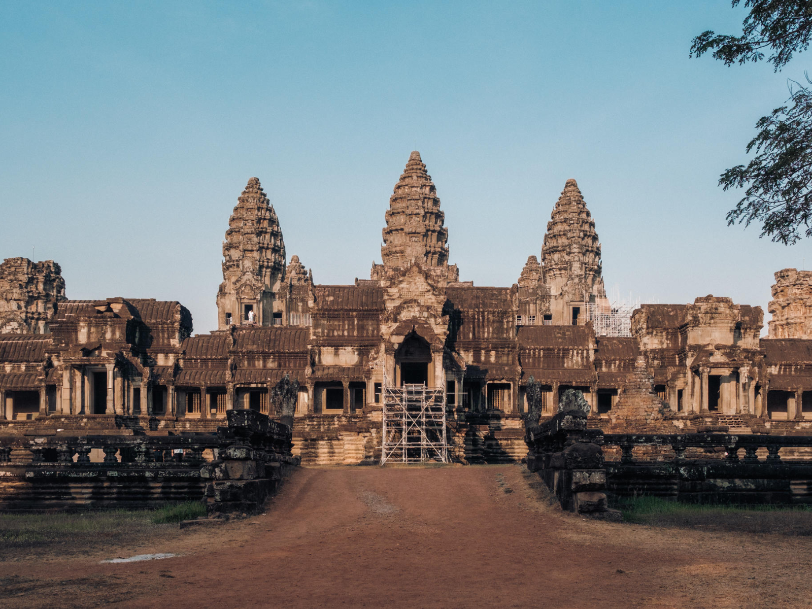
Angkor Wat
Angkor Wat was built in the first half of the 12th century as a state-level project under Suryavarman II. It is the best-preserved and largest single temple in Angkor. Its defining feature lies first in its spatial organization: a wide moat and long causeway on the outside, with multiple enclosures and galleries that progressively converge toward the center. At its core stands a five-tower structure, with a clear axial layout and hierarchical order, making it feel more like a precisely planned religious complex.


The overall conception of Angkor Wat is closely tied to Hindu cosmology, with the most central image being Mount Meru. In both Hindu and Buddhist traditions, Mount Meru is regarded as the center of the universe, where the gods reside, surrounded by oceans and mountain ranges, forming a layered cosmic model. The most direct architectural expression of this idea is the five-tower layout. The central tower, together with the four surrounding towers, forms a quincunx pattern, often interpreted as representing the main peak of Mount Meru and its surrounding peaks. As you move from the outer areas inward, you pass through the moat, causeway, enclosures, and multiple galleries; the space gradually narrows and the elevation rises step by step. This progression—from the outer to the inner, from low to high—simulates the journey from the mortal world into the divine center. In particular, the steep and narrow staircases leading up through the three levels of galleries and terraces are intentionally designed to evoke a sense of physical and spiritual submission to the divine.


The most important viewing content at Angkor Wat lies in its bas-relief galleries. The western gallery features the famous “The Battle of Lanka,” drawn from the Ramayana, with dense compositions and an astonishing number of figures. The southern gallery depicts the “Churning of the Sea of Milk,” where gods and asuras pull the serpent king Vasuki to churn the ocean and obtain the elixir of immortality—one of the most iconic mythological scenes in Angkor. In terms of religious identity, Angkor Wat was originally dedicated to Vishnu, but gradually became Buddhist over time. As a result, it accumulated layers of religious traces across different periods, making it both a Hindu state temple and later a vessel for Buddhist practice.


Throughout Siem Reap, you can often see local practitioners dressed in orange robes.

Angkor Thom
“Angkor” is derived from the Sanskrit word Nagara (city). It lies between Phnom Kulen and Tonlé Sap, with the Siem Reap River flowing southward from its northern source in Phnom Kulen into Tonlé Sap. It is precisely this water system, together with the surrounding large-scale hydraulic engineering, that elevated Angkor from a collection of temples into a city system capable of long-term operation.
Within this entire “urban system,” the most city-like component is not Angkor Wat, but Angkor Thom. It resembles a clearly bounded royal city: a square enclosure formed by city walls, surrounded by a wide moat, with gates distributed along the walls leading in all four directions. Outside each gate, long causeways are lined with rows of deities and asuras, forming a ritualized path of प्रवेश. The construction and expansion of Angkor Thom are closely associated with Jayavarman VII, who incorporated both the political and religious centers within the city, making it not only a container of administrative power but also a stage for state belief.

At the center of the royal city stands Bayon, which also served as the state temple during Jayavarman VII’s reign. Its most distinctive and unmistakable feature is the dense array of four-faced towers. These faces are numerous and widely distributed, creating a visual effect of “faces surrounding you” from nearly every angle. Bayon’s layout is complex, with densely packed towers, and galleries, doorways, and courtyards that constantly shift and turn. Compared to most Angkor temples, its spatial hierarchy feels more fragmented and compact.


The outer gallery bas-reliefs are extremely rich in content. Beyond religious themes, they depict a large number of scenes from warfare and daily life, including processions, boats, water activities, and market scenes. This makes Bayon not only the religious core of the royal city but also an important site preserving secular visual records. Religiously, it is primarily Mahayana Buddhist, with later Hindu additions layered onto it. This accumulation of different periods is also reflected in its imagery and structural details, giving it a stronger sense of hybridity and historical layering among Angkor temples.


Bas-relief details

Walking along the core of the royal city, you will soon encounter another structure with a completely different character: Baphuon. Built in the mid-11th century, it belongs to an earlier generation of state temples of the “temple mountain” type. Originally dedicated to Shiva, it was later converted to Buddhism. Baphuon is defined by its elevated platform and emphasis on ascent, highlighting a sense of power conveyed through height and vertical movement. The staircases are extremely steep, but once you reach the corridors above, it oddly feels like moving through the world of the game Temple Run.


Steep staircases and corridors reminiscent of Temple Run
Phimeanakas, the “Celestial Palace,” is also located within the royal city, forming part of the palace complex. Though not large in scale, its positional significance is strong, emphasizing the spatial hierarchy along the palace’s central axis. Essentially, it is a small stepped temple mountain, characterized by three tiers of platforms rising upward and its close integration with the enclosed royal living spaces.

Between the religious center and the palace complex, there are also structures that more directly served royal ceremonies, such as the Terrace of the Elephants and the Terrace of the Leper King. These consist of long stretches of bas-relief platforms forming continuous decorative bands, often featuring elephants, garudas, and guardian figures, emphasizing spaces for ceremonies, parades, and public display. The Terrace of the Elephants lies directly adjacent to the royal palace area, a spatial relationship that also gave it ceremonial significance: officials would enter the court system here, completing their audience and ritual procedures before the king.


Elephants on the terrace


Other sites on the small circuit: Ta Prohm, Ta Keo, Chau Say Tevoda, Prasat Kravan, Phnom Bakheng
Ta Prohm was built from the late 12th to early 13th century as part of the temple-city system under Jayavarman VII, with a Mahayana Buddhist background. Its uniqueness lies in the visual result of preservation status combined with the natural environment: large tree roots intertwine with walls, doorframes, and galleries, forming recognizable scenes of “roots pressing against walls” and “roots spanning gateways.” The internal space is composed of repeated combinations of gateways, corridors, and courtyards, with partial preservation of lintels, columns, and collapsed walls layered together. The original architectural order is disrupted by collapse and vegetation, so the visual focus often falls on “points of rupture and connection” rather than central towers or symmetrical compositions. Unlike Angkor Wat’s narrative clarity through bas-reliefs, Ta Prohm’s identity is more about form and condition—it represents a typical state of Angkor ruins after long-term evolution in a humid environment.


Ta Keo, located on the small circuit, is generally dated to the late 10th to early 11th century. It is a typical temple mountain built of sandstone, with an appearance that conveys a unified sense of being “unfinished.” I climbed to the top, but compared to other temples, it did not feel particularly distinctive or worth extended attention.


Chau Say Tevoda, also on the small circuit, is smaller in scale but stands out for its refinement and preservation. Together with the opposite Thommanon, it is considered a more niche temple. I passed by twice and found very few visitors. However, it is surprisingly photogenic—worth stopping by if you want good photos.


Prasat Kravan is not large, but its distinctive feature is the rare arrangement of five towers aligned in a straight line. Inside, the brick chambers preserve unusual brick bas-reliefs, most famously depicting Vishnu.


Phnom Bakheng stands at a higher elevation than most other temples, making it one of the best spots for sunset views. The ruins at the summit are not large, so there is no need to stay too long—just find a good spot, sit quietly, and wait for the sunset.


Grand Circuit: Preah Khan, Neak Pean, Ta Som, East Mebon, Pre Rup
Preah Khan was built in the late 12th century and is one of the important temple-city complexes from the reign of Jayavarman VII, with a primarily Mahayana Buddhist background. Its functionality and scale are both prominent. Its defining feature is the layered progression of space combined with repeated sequences of gateways and galleries: moving from the outer to the inner zones, you continuously pass through doorways and corridors, creating a strong sense of “continuous space.” Compared to Ta Prohm, which is famous for its entanglement with tree roots, Preah Khan is more identifiable through its layout and structural system itself, making it especially suitable for observing sequences of gateways, gallery structures, and courtyard combinations. It also preserves some representative components and carvings, but overall it feels more like a “systematic grand temple,” distinguished by its scale and structural complexity.


Neak Pean (also known as Neak Pean / “Nirvana Temple”) is located along the grand circuit and is often interpreted as an architectural expression of medical and purification concepts during Jayavarman VII’s reign. Its structure is highly unique: a central island shrine surrounded by water, connected to the outside by a causeway, with four surrounding pools arranged along the cardinal directions. The entire design revolves around the “distribution and symbolism of water.” Unlike most temples defined by platforms, towers, and galleries, Neak Pean stands out as a temple built in the middle of a body of water. In ancient times, people would travel by boat to the island seeking healing; today, wooden walkways allow visitors to access it, and the experience differs between the dry and rainy seasons.


Ta Som is relatively small, a minor temple along the grand circuit. It once stood out among many temples because of a large tree growing over its rear gate, but that tree is no longer there.


East Mebon was built in the 10th century and is a typical temple mountain. It originally stood on an artificial island in the middle of the East Baray reservoir, and this geographical setting is a key part of its identity. Although the reservoir has mostly dried up today, the idea of an “island temple” still helps explain how Angkor integrated hydraulic engineering with religious architecture. The temple rises through layered platforms, often decorated with stone elephants at the corners, emphasizing elevation and symmetrical layout.


Pre Rup, also known as the “Transformation Tower,” belongs to the 10th-century temple mountain system. It is relatively large, with high platforms and open terraces, surrounded by forest, and is also a good place to watch the sunset. Scholars generally believe it was closely associated with royal funeral rites and served as one of the state temples for cremation ceremonies of deceased kings or royalty. In Khmer tradition, cremation is common, and within the Hindu framework, death and ritual are integrated into cycles of rebirth and liberation. Royal funerary rites use fire and offerings to symbolically transform the deceased, allowing them to transition from a worldly identity to a higher sacred status.


Outer Circuit: Koh Ker, Beng Mealea, Roluos Group, Banteay Srei
The Koh Ker temple complex lies farthest from the city and briefly served as the political center of the Khmer Empire in the 10th century. Its significance is not just its distance, but the fact that it was once the center. Its most recognizable feature is the pyramid-style temple around Prasat Thom, with clear tiers and a highly distinctive form that differs greatly from the typical temple silhouettes of the Angkor core area. The ruins are scattered and require transportation to connect them, and the temples vary significantly in scale, preservation state, and decorative density.


Beng Mealea, located on the outer circuit, is large in scale and shares a similar layout with Angkor Wat, but its state of preservation is entirely different, giving it the feeling of an “unrestored ruin.” Its defining features are collapse, overgrowth, and traversability: fallen walls forming piles of stone, structures covered in vegetation, and pathways that require climbing over obstacles all shape the viewing experience. Unlike the main temples where you move along galleries, Beng Mealea feels more like navigating through remnants of structures. The visual focus falls on fractures, overlapping collapsed elements, and the interplay between ruins and forest. It is highly distinctive and one of the most memorable types of sites in the outer circuit.


The Roluos Group usually includes Bakong, Preah Ko, and Lolei. Dating back to the 9th century, they represent an important starting point before the Angkor system. Their uniqueness lies in their “early forms”: more direct temple-mountain structures, simpler decoration, and proportions that differ noticeably from the mature Angkor style. The focus here is more on historical context and stylistic evolution—you can see early prototypes of later Angkor conventions, such as tower layouts, platform hierarchies, and the combination of gateways and enclosures. It does not aim to impress visually but to make the timeline tangible. Unless you are particularly enthusiastic, it may not be worth a separate trip, as it does not stand out significantly compared to other Angkor temples.


Banteay Srei was built in the 10th century. Though small in scale, it holds an extremely high status in craftsmanship and art history, often considered the pinnacle of Angkor’s bas-relief detail. Its uniqueness comes from its material and carving: extensive use of red sandstone allows for highly refined detailing, resulting in exceptionally dense decorative elements on lintels, columns, and pediments. Figures, deities, patterns, and narrative scenes are clearly defined and richly layered. The themes are mostly drawn from Hindu mythology and epics, making them somewhat difficult to interpret, but even without understanding them fully, the intensity of craftsmanship can be appreciated through the lines and density. It is a temple that rewards time spent on details rather than scale.


One of the most famous anecdotes about Banteay Srei is that in 1923, the French writer André Malraux stole four devata statues from the temple, causing a major scandal. He was quickly arrested, and the stolen artifacts were recovered and returned to Cambodia. Ironically, he later became France’s Minister of Culture—a testament to a certain French nonchalance. This is also one of the temples where I strongly recommend hiring a guide; without explanation and some knowledge of Hindu history, you may only get a superficial understanding.


Additionally, Banteay Srei is the only temple in Angkor where barriers have been installed, preventing close-up viewing. If you are interested in the bas-reliefs and plan to examine them in detail, I would recommend bringing binoculars or a telephoto lens for a better experience.


6. Other Attractions in Siem Reap
Angkor National Museum
Angkor National Museum feels more like a preparatory step before visiting the Angkor complex. Its exhibitions focus on the religious and iconographic systems of the Angkor period—such as deities, nāgas, asuras, apsaras, and symbols of royal power—helping you become familiar with these recurring motifs before entering the temples. The museum also provides some basic explanations of architectural structures, allowing you to roughly understand the relationships between galleries, gateways, tower clusters, temple mountains, and water systems. For first-time visitors to Angkor, this kind of structured introduction is very effective, reducing the sense of unfamiliarity during subsequent visits and improving your ability to interpret bas-reliefs and spatial layouts.
Admission: $12, audio guide $5 (not recommended—it essentially just reads out the printed text)
Note that you need to store your bag before entering; cameras are not allowed, and flash photography is prohibited. The storage counter at the entrance thoughtfully provides a small cloth bag for your personal belongings.


It’s also worth mentioning that the museum’s souvenir shop is well worth browsing, with many interesting items not easily found elsewhere. Across the street is Siem Reap’s largest Chinese supermarket, “Angkor Supermarket,” which also offers a wide selection of food products and souvenirs suitable as gifts.
Kompong Phluk Floating Village and Tonlé Sap Lake
During the rainy season each year, when the Mekong River reaches its peak, it triggers a reversal of flow in the Tonlé Sap River. Water is pushed into Tonlé Sap, significantly expanding the lake and surrounding wetlands. The incoming water brings nutrients, sediment, and migratory fish pathways, flooding forests and lowlands and creating vast shallow-water habitats rich in food for breeding and nurturing young. In the dry season, water levels recede, the lake shrinks, and water and aquatic life retreat into deeper channels and the lake’s center. The floating villages adjust their way of life accordingly, shifting with the changing water boundaries.
Kompong Phluk is a typical example of such a floating village. Houses are elevated to adapt to rising water levels and seasonal flooding. During the rainy season, water transport becomes the main mode of commuting, and infrastructure such as schools, shops, and even toilets is organized around the water. In the dry season, when some waterways become shallow or reveal mudflats, people spend more time living on land.


Another part of the tour involves visiting the village itself. As soon as you disembark, you notice the dusty roads, and the houses and infrastructure are very simple—some places even resemble rural China from over twenty years ago. Along the way, we passed a donated library and school. The guide said: “Because 80% of people in Siem Reap are directly or indirectly involved in tourism, our schools have introduced English classes. English has become a compulsory subject, and because of your presence, our next generation has more opportunities and possibilities.” Hearing this was genuinely reassuring.


Another optional activity during the trip is a boat ride through the mangrove forest. Once the small boat turns from the main waterway into narrower channels, the surrounding sounds suddenly soften, and the air takes on a distinct scent—cool and slightly spicy, like lemongrass. In that moment, I suddenly understood why massage shops in Siem Reap often emphasize lemongrass essential oil. It’s because their natural environment is already infused with this scent; the oil simply concentrates it and brings it indoors, turning it into something that can be remembered in everyday life. A fellow traveler tipped the boatwoman, and we were lucky enough to hear her sing a Khmer folk tune while drifting along—an incredibly relaxing experience.


The final part of the itinerary is watching the sunset over Tonlé Sap. I brought a tripod, planning to shoot a time-lapse, only to realize after boarding that the entire sunset would be viewed from the water—the slight rocking of the boat made it impossible, and before I knew it, the sun had drifted away. The vastness of Tonlé Sap has a very direct, almost overwhelming presence. The horizon flattens into little more than water and sky, with the boat appearing as a tiny dot placed upon it. Because of this, it’s hard not to think about the past. The Khmer people lived, fished, and migrated here, with the lake expanding and contracting through rainy and dry seasons—they must have witnessed countless sunsets like this. In many places, lakes carry the imagination of the sea. For those who rarely see the ocean, a vast body of water can become its substitute. Did people in the past also imagine the sea through great lakes like this?
After sunset, we returned by boat. As we approached the dock, the lights became sparse, and the trees along the shore appeared even darker. Above the silhouette of the forest, I saw the moon again. It hung low and steady, as if it had been reserved as the final image of the day. It was truly a beautiful and peaceful journey—one I would recommend to everyone.


APOPO Landmine Detection Center
APOPO is one of the few “non-temple must-visit” spots in Siem Reap. It is backed by a European non-profit organization that trains African giant pouched rats (HeroRATs) to detect landmines, turning their keen sense of smell into a scalable tool for public health and safety. When talking about Cambodia, one cannot avoid the issue of landmines and unexploded ordnance left over from the civil war and the Vietnam War era. The impact is not limited to border or remote areas—many agricultural lands, forests, and village surroundings still pose risks, leading to long-term consequences such as injuries, unused land, and restricted infrastructure development. (Warning: images of large rats below)
The core of APOPO’s method lies in standardized training and quality control. The rats are trained in controlled environments to identify the scent of explosives and move along grid-based paths in simulated minefields or testing areas to locate suspicious spots. Their light weight reduces the risk of triggering mines. The visit also demonstrates training procedures, the principles behind real-world operations, and the significance of demining for restoring land use. At the end, there is even an opportunity to take photos with the rats—a surprisingly relaxing experience and a nice break between temple visits.
Admission: $10, advance booking recommended


Phsar Leu Thom Tmey
Phsar Leu Thom Tmey is a more local morning market in Siem Reap. The stalls are densely packed, with daily necessities, fresh ingredients, and cooked food all sold side by side. Locals ride motorcycles through the narrow aisles—it feels no different from the morning markets back in my hometown. It’s a great place to observe everyday local life: how people shop, how ingredients are displayed, and how vendors handle prepared food and seasonings. For those interested in exploring food and daily culture, you can find fresh and diverse local fruits and snacks here—it’s a must-visit for culinary explorers.


7. Conclusion
Before departure, my imagination of Cambodia was filled with uncertainty. But once I actually set foot on this land, my mind became strangely calm. The concerns didn’t disappear—they just became less important. People working in tourism here seem to treat “taking care of you” as an instinct, and even their smiles feel effortless. On the last day of the trip, I watched a sunset from inside a car. I simply sat there, waiting as the light slowly faded. After passing through airport security, I saw the moon hanging in the sky again. In that moment, it felt as if the memories of the past few days connected together: papaya smoothies at the night market, the lotus-scented body lotion I bought, the moon hanging above the jungle, the Khmer music played at temple entrances. What I wanted to take away with me were these moments—they are lighter than any souvenir, yet far more unforgettable.
8. References
Books: The Rise and Fall of the Angkor Kingdom, The Beauty of Angkor, Lonely Planet: Cambodia, Southeast Asia: Discovering a Multi-Civilization World, Cambodia: The Cursed Land
Online: Xiaohongshu feed recommendations; Mr. Angkor In-Depth Travel Notes on Angkor Wat; Wikipedia
Offline: Angkor National Museum guide materials; Angkor Wat tour guide explanations
Photography: iPhone 16, Fujifilm X-S20 + XF 16–50mm
Post-processing: Lightroom, Photoshop, Gemini
Leave a Reply